- County Route 36 (Suffolk County, New York)
-
County Route 36
South Country Road Route information Maintained by SCDPW Length: 5.55 mi[1] (8.9 km) Existed: 1930–1932 – present Major junctions west end:  CR 80 in Brookhaven
Munsell Road in Hagerman
Bellport Avenue in Bellport
Beaver Dam Road in Brookhaveneast end: CR 80 in BrookhavenHighway system Numbered highways in New York
Interstate • U.S. • N.Y. (former) • Reference • County (Suffolk)←  CR 35
CR 35CR 37  →
→Suffolk County Road 36 is a county road in Central-Southern Suffolk County, New York. Though it is signed as an east–west road, it runs southeast to north from Suffolk County Road 80(Montauk Highway) and Lake Drive in East Patchogue back to Montauk Highway in Brookhaven. The entire road is two lanes wide, with exceptions for provisions for left turns at some intersections.
Contents
Route description
South County Road begins on the east bank of the Swan River at the intersection of Montauk Highway and Lake Drive, with a four way intersection that includes an eastbound connecting ramp. Almost immediately it crosses the Montauk Branch of the Long Island Rail Road after the intersection of Robinson Avenue. The former East Patchogue Station was located west of this intersection (Hagerman Station was further east along the line). Luxurious houses line the road from most of this point on.
 County Road 36 along Robinson Pond
The bridge over Robinson Pond has a similar appearance to the one on Montauk Highway over Forge River between Mastic and Moriches. On the opposite side of Robinson Pond is the Mud Creek County Nature Preserve, a protected area controlled by the Suffolk County Department of Parks and Recreation. Other protected land exists along Strongs Creek and Abet's Creek in Hagerman, the latter of which used to be the location of a Greenhouse. The last intersection outside of the Village of Bellport is Munsell Road, a pre-automotive era road that once went as far north as West Yaphank.
Bellport County Club serves as the unofficial border of the Historic Village of Bellport. The intersection with Bellport Avenue to the north and Bellport Lane to the south is the heart of Bellport. Bellport Avenue leads to the town's LIRR station, but also through North Bellport, the edges of Yaphank and Medford, and once lead as far north as Gordon Heights. Bellport Lane, along with SCR 36 is one of the streets bordering the Bellport Village Historic District, which has been listed on the National Register of Historic Places since 1980.[2]
 County Road 36 in historic Bellport Village
Just outside of the village at Mott's Brook, SCR 36 passes by the Gateway Playhouse which was established in 1941 on the grounds of a former farm owned by J. L. B. Mott. Well past the intersection of Bellhaven Avenue, the road begins to turn north as it follows the west bank of Beaver Dam Creek, which is hidden off to the east. Very little evidence of this or any other waterway exists along this section of the road until it reaches a hidden driveway leading to a Yacht Club near the southeast corner of Beaver Dam Road. Most of the houses along the road appear to be far more Victorian from this point on. For a moment, the road curves back to the east before intersecting with Fireplace Road, then heads back into a northerly direction.
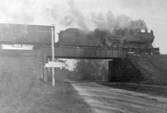
The northeastern end runs beneath a low bridge for the Montauk Branch of the Long Island Railroad[3] where it intersects with Railroad Avenue (the former location of Brookhaven Station) before finally terminating at Montauk Highway.
History
Originally part of Montauk Highway, the road was created on February 24, 1930 when it shared a designation with New York State Route 27 which was part of Montauk Highway at the time. It was completely turned over to Suffolk County on July 17, 1932, when New York State realigned Montauk Highway on the north side of the Montauk Branch of the Long Island Rail Road. Since then it has been used as the main road through the Village of Bellport.
Until the late-1980's, flood insurance maps published by the Federal Emergency Management Agency have misrepresented South Country Road as being New York State Route 95. South Country Road has never been either NY 95, nor Suffolk County Road 95.
References
- ^ "County Road System – County of Suffolk, New York" (PDF). Suffolk County Department of Public Works. December 29, 2005. http://www.greaternyroads.info/pdfs/suffcr.pdf. Retrieved April 2, 2010.
- ^ "Suffolk County Listings at the National Register of Historic Places (NRHP #02001451)". http://www.nationalregisterofhistoricplaces.com/NY/Suffolk/state.html. Retrieved April 2, 2010.
- ^ "1900 View of South Country Road railroad bridge in Brookhaven, New York". TrainsAreFun. http://trainsarefun.com/lirr/trestles/scountryrdviewnorthc.1900.jpg. Retrieved April 2, 2010.
External links
Categories:- County routes in Suffolk County, New York


Wikimedia Foundation. 2010.