- Musselman Lake, Ontario
-
Musselman Lake — Unincorporated community — Coordinates: 44°1′51″N 79°16′23″W / 44.03083°N 79.27306°W Country Canada Province Ontario Regional municipality York Region Town Whitchurch–Stouffville Amalgamation (With Town of Stouffville)
1 January 1971Government – Type Municipality – Mayor Wayne Emmerson – Councillor Phil Bannon (Ward 2) Elevation 334 m (1,096 ft) Time zone EST (UTC−5) – Summer (DST) EDT (UTC−4) Forward sortation area L4A Area code(s) 905 and 289 NTS Map 031D03 GNBC Code FDLCI Musselman Lake is a community settled adjacent to a 123-acre (0.50 km2) kettle lake of the same name in the town of Whitchurch–Stouffville, Ontario, Canada. It is located about 6 km north-northwest of urban Stouffville, and is part of the Greater Toronto Area.
It is accessible from Highway 48, which links Toronto to Beaverton. Highway 404, a limited-access 400-Series Highway 9 km west of Musselman Lake and which first opened in the early 1980s, is reached by Aurora Road. Located just south of Musselman Lake on the west side of Ninth Line is Windsor Lake, a much smaller kettle lake. The main streets are Vandorf Sideroad to the north, and Bloomington Road to the south. Musselman Lake feeds a small tributary to the East Holland River, which flows to the west.
Contents
Geography
Musselman Lake is part of the Oak Ridges Moraine, with much of the area forested and the moraine dividing the Lake Ontario and Lake Simcoe basins itself divided at Musselman Lake. Residential areas are around the two lakes and on a few other large lots within Musselman Lake. Pine trees dominate much of the area along with a couple of hills. Farmland covers the rest of the northeastern portion of Whitchurch–Stouffville. Creeks and streams are also characteristic of the area. Sand and gravel mining is widespread to the south and east of Musselman Lake. Musselman Lake has several mining areas and quarries. The mining industry began in the 1950s and continues through the present. In the early 2000s, a building whose construction was already under way had it halted for good to protect the moraine. In 2009 the Musselman's Lake Subwatershed Assessment and Stewardship Opportunities Report was recognized that the water quality of the lake was "impaired" and "degraded," and had declined since 1989 when similar study had been done.[1]
History
The area was first settled 1807 by Peter and Jacob Musselman, Mennonites from Pennsylvania.[2]
In the 1950s and 1960s housing developments was built around Musselman Lake.
A significant issue facing the Musselman Lake community in the coming years is the federal government's proposed development of an international airport immediately south-east of Whitchurch–Stouffville (the Pickering Airport lands); under the current plan, an approach for one of the three landing strips would be directly above the communities of Ballantrae and Musselman Lake, with planes descending (or ascending) from 500 to 450 metres. The plan calls for 11.9 million passengers per year (or 32,600 per day) by 2032.[3] A "Needs Assessment Study" was completed by the Greater Toronto Airports Authority for the federal government in May 2010. After a "due diligence review," Transport Canada released the report in July 2011.[4]
Privately owned waterfront
Virtually all of the water front in the community of Musselman's Lake is private residential property. Musseman's Lake itself is a natural lake and thus crown property, not private: use of the lake and its shorelines is regulated by the Department of Fisheries and Oceans Canada in conjunction with the Toronto and Region Conservation Authority (including some funding for shoreline restoration); the Ministry of Natural Resources governs fishing regulations, town by-laws regulate the use of power boats on the lake, and laws are enforced by the York Regional Police Marine Unit. While the resources of all levels of government are used for the regulation, protection and preservation of the lake, the entire perimeter of the lake is currently in private hands, and homeowners and business alone benefit from exclusive access rights to one of Whitchurch-Stouffville's most significant natural and recreational assets.
Nearest communities
Musselman's Lake is situated near the eastern boundary of the town of Whitchurch–Stouffville. Neighbouring communities within Whitchurch–Stouffville include Ballantrae to the north-east and Bloomington to the south. Goodwood, a community of the town of Uxbridge, lies to the east.
References
- ^ Cf. Lake Simcoe Conservation Authority and the Town of Whitchurch-Stouffville, Musselman's Lake Subwatershed Assessment and Stewardship Opportunities Report, March 31, 2009.
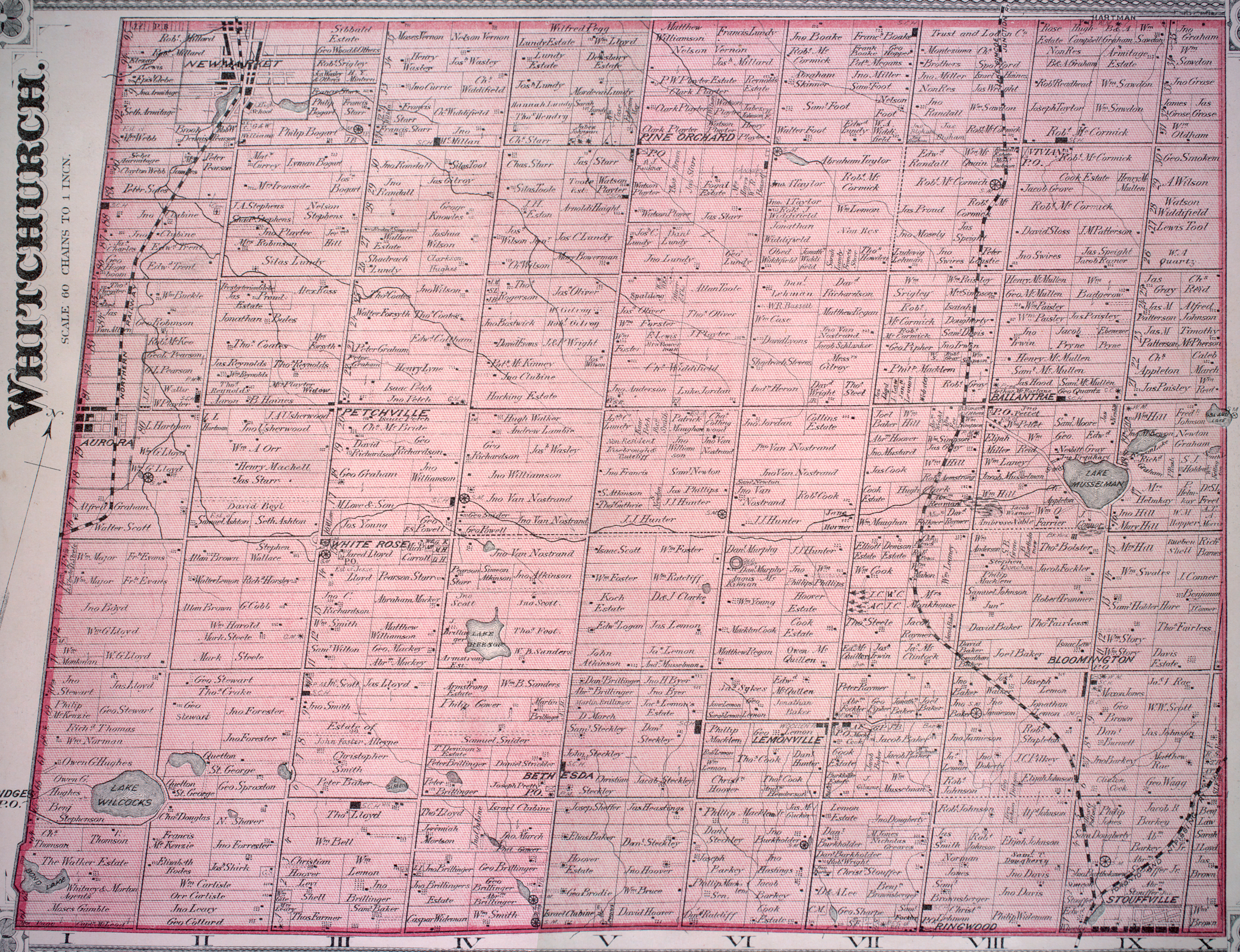
- ^ For a complete history of Musselman Lake, see Jean Barkey et al, Whitchurch Township (Erin, ON: Boston Mills, 1993), 102-105. See also the detailed 1878 map, Township of Whitchurch, Illustrated historical atlas of the county of York and the township of West Gwillimbury & town of Bradford in the county of Simcoe, Ont. (Toronto: Miles & Co., 1878); The Community of Musselman's Lake: A Little History, Musselman's Lake Residents Association (MLRA) official website. Cf.
- ^ Cf. Transport Canada, Plan Showing Pickering Airport Site; also Greater Toronto Airports Authority, Pickering Airport Draft Plan Report, 6.3.
- ^ Transport Canada, News Release: "Transport Canada releases findings of the 2010 Pickering Lands Needs Assessment Study," July 11, 2011.
Communities of Whitchurch–Stouffville, Ontario Ballantrae · Bethesda · Bloomington · Gormley · Lemonville · Lincolnville · Musselman Lake · Pine Orchard · Pleasantville · Preston Lake · Ringwood · Stouffville · Vandorf · Wesley CornersCommunities in other York Region municipalities: King • Markham • Richmond Hill • Vaughan • Whitchurch–StouffvilleCategories:- Communities in Whitchurch–Stouffville
Wikimedia Foundation. 2010.