- Cross City Airport
-
Coordinates: 29°38′07.90″N 083°06′17.10″W / 29.635528°N 83.10475°W
Cross City Airport 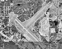
6 February 1999 IATA: CTY – ICAO: KCTY – FAA LID: CTY Summary Airport type Public use Owner Dixie County Board of Commissioners Operator Clint Beauchamp Serves Cross City, Florida Location Dixie County, Florida Elevation AMSL 42 ft / 13 m Runways Direction Length Surface ft m 4/22 5,005 1,525 Asphalt 13/31 5,001 1,524 Asphalt Statistics (2000) Aircraft operations 18,000 Based aircraft 11 Source: Federal Aviation Administration[1]  Cross County Army Airfield, 1944
Cross City Airport (IATA: CTY, ICAO: KCTY, FAA LID: CTY) is a public-use airport located 1 mile (1.6 km) east of the central business district of the town of Cross City in Dixie County, Florida, United States. The airport is publicly owned.[1] It was used by the United States Air Force under the name of Cross City Air Force Station
History
Main article: Cross City Air Force StationThe airport was opened as a public airfield in April, 1940. In August 1942, the facility was requisitioned by the United States Army Air Forces as a World War II military airfield, and was named Cross City Army Airfield. The airfield was assigned as a training base to the Army Air Forces School of Applied Tactics (AAFSAT), 50th Fighter Group, headquartered at Orlando Army Air Base.
After the war, the airfield was returned to civil control. However, in the 1950s, the United States Air Force re-established a RADAR facility on the airport under the operational control of the 891st Radar Squadron of the Air Defense Command (ADC). This facility remained at Cross City Air Force Station and was part of the ADC's 20th Air Division from 1959 to 1969 when the facility was closed.[2]
References
- ^ a b FAA Airport Master Record for CTY (Form 5010 PDF), effective 2008-02-14
- ^ USAFHRA Document 00463594
External links
- Resources for this airport:
- AirNav airport information for CTY
- FlightAware airport information and live flight tracker
- SkyVector aeronautical chart for CTY
Categories:- Airports in Florida
- Transportation in Dixie County, Florida
- Buildings and structures in Dixie County, Florida


Wikimedia Foundation. 2010.