- Hartsville, Tennessee
Infobox Settlement
official_name = Hartsville, Tennessee
settlement_type =Town
nickname =
motto =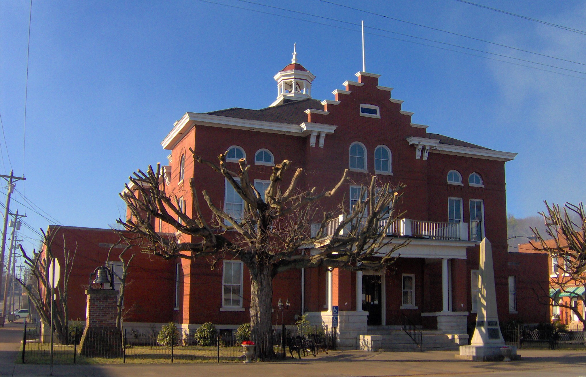
imagesize = 250px
image_caption = Trousdale County Courthouse in Hartsville
image_
mapsize = 250x200px
map_caption = Location of Hartsville, Tennessee
mapsize1 =
map_caption1 =subdivision_type = Country
subdivision_name =United States
subdivision_type1 = State
subdivision_name1 =Tennessee
subdivision_type2 = County
subdivision_name2 = Trousdalegovernment_footnotes =
government_type =
leader_title =
leader_name =
leader_title1 =
leader_name1 =
established_title =
established_date =unit_pref = Imperial
area_footnotes =
area_magnitude =
area_total_km2 = 9.2
area_land_km2 = 9.2
area_water_km2 = 0.0
area_total_sq_mi = 3.6
area_land_sq_mi = 3.6
area_water_sq_mi = 0.0population_as_of = 2000
population_footnotes =
population_total = 2395
population_density_km2 = 260.1
population_density_sq_mi = 673.5timezone = Central (CST)
utc_offset = -6
timezone_DST = CDT
utc_offset_DST = -5
elevation_footnotes =
elevation_m = 144
elevation_ft = 472
latd = 36 |latm = 23 |lats = 30 |latNS = N
longd = 86 |longm = 9 |longs = 37 |longEW = Wpostal_code_type =
ZIP code
postal_code = 37074
area_code = 615
blank_name = FIPS code
blank_info = 47-32720GR|2
blank1_name = GNIS feature ID
blank1_info = 1287064GR|3
website =
footnotes =Hartsville is a town in Trousdale County,
Tennessee ,United States . It is thecounty seat of Trousdale CountyGR|6, with which it shares aconsolidated city-county government. The population of Hartsville was 2,395 at the 2000 census, but after consolidation with the county in 2001, the population of the consolidated entity became equal to that of the county (7,259 in 2000). [ [http://www.mtas.utk.edu/public/web.nsf/Search/CitiesName?opendocument Municipal Technical Advisory Service] (accessed November 29, 2007)]Hartsville is the county seat of
Trousdale County, Tennessee and now coextensive with it as ametropolitan government by virtue of areferendum which passed in Trousdale County by a single vote. Trousdale CountyHigh School is located here, as well as a technical school operated by the Tennessee Board of Regents. Trousdale County is one of two counties in Tennessee to have legalizedparimutuel betting onhorse racing , but no group has ever stepped forward to build a racetrack. [Ridley Wills II, " [http://tennesseeencyclopedia.net/imagegallery.php?EntryID=T091 Thoroughbred Horse Breeding and Racing] ." "The Tennessee Encyclopedia of History and Culture", 2002. Retrieved: 11 February 2008.] Hartsville is located slightly north of theCumberland River and is approximately fifty miles northeast ofNashville .In 1977, the
Tennessee Valley Authority began construction on the Hartsville Nuclear Plant, but cancelled the project in 1984 after spending nearly two billion dollars. [Jeffrey Durbin, " [http://tennesseeencyclopedia.net/imagegallery.php?EntryID=T115 Trousdale County] ." "The Tennessee Encyclopedia of History and Culture", 2002. Retrieved: 11 February 2008.] The plant's unused cooling tower dominates the view south from State Route 25 between Smith County and Trousdale County.Geography
Hartsville is located at coor dms|36|23|30|N|86|9|37|W|city (36.391617, -86.160172)GR|1. The town's business district is situated along the West Fork of Goose Creek, which flows down into Trousdale County from the hills to the north and empties into the
Old Hickory Lake impoundment of theCumberland River several miles to the south. A large hill rises immediately to the west of the business district and overlooks the entire eastern half of the county.Hartsville lies at the junction of State Route 25, which connects the town with Carthage to the southeast and Sumner County to the west, and State Route 141, which connects Hartsville with Lebanon to the south and Macon County to the north.
According to the
United States Census Bureau , the town had a total area of 3.6 square miles (9.2 km²) in 2000, all of it land.Demographics
As of the
census GR|2 of 2000, there were 2,395 people, 938 households, and 601 families residing in the town. Thepopulation density was 673.5 people per square mile (259.8/km²). There were 1,043 housing units at an average density of 293.3/sq mi (113.1/km²). The racial makeup of the town was 75.70% White, 22.46% African American, 0.29% Native American, 0.21% Asian, 0.04% Pacific Islander, 0.84% from other races, and 0.46% from two or more races. Hispanic or Latino of any race were 1.46% of the population.There were 938 households out of which 29.1% had children under the age of 18 living with them, 42.2% were married couples living together, 18.9% had a female householder with no husband present, and 35.9% were non-families. 31.2% of all households were made up of individuals and 13.8% had someone living alone who was 65 years of age or older. The average household size was 2.38 and the average family size was 2.96.
In the town the population was spread out with 23.3% under the age of 18, 8.9% from 18 to 24, 26.1% from 25 to 44, 22.5% from 45 to 64, and 19.1% who were 65 years of age or older. The median age was 39 years. For every 100 females there were 87.4 males. For every 100 females age 18 and over, there were 81.2 males.
The median income for a household in the town was $26,797, and the median income for a family was $33,523. Males had a median income of $27,232 versus $21,429 for females. The
per capita income for the town was $14,226. About 17.0% of families and 19.7% of the population were below thepoverty line , including 21.0% of those under age 18 and 24.3% of those age 65 or over.History
The first Euro-American settlers arrived in what is now Hartsville in 1797, when the family of James Hart settled along the west bank of the West Fork of Goose Creek, and the family of Charles Donoho settled along the creek's east bank. Donoho erected a mill shortly thereafter, and the town was initially known as Donoho's Mill. James Hart established Hart's Ferry along the Cumberland several miles to the south, and purchased the Donoho property in 1800. Hartsville was officially recognized as a town in 1817. Donoho's Mill, on the east bank of the creek, had become known as "Damascus," although it merged with Hartsville in 1840 when Hartsville officially incorporated. [" [http://www.hartsvilletrousdale.com/ Trousdale County History] ." Retrieved: 11 February 2008.]
During the
American Civil War , Hartsville was site of theBattle of Hartsville , which occurred in 1862.References
External links
* [http://www.hartsvilletrousdale.com/ Hartsville — Trousdale County] — official site
Wikimedia Foundation. 2010.