- Chewelah, Washington
-
Chewelah, Washington — City — Location of Chewelah, Washington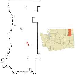
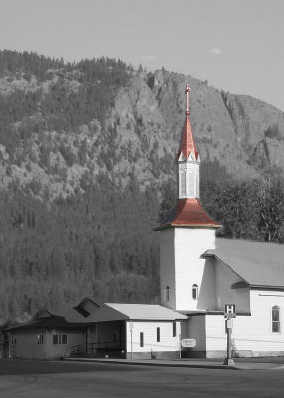
Coordinates: 48°16′50″N 117°43′23″W / 48.28056°N 117.72306°WCoordinates: 48°16′50″N 117°43′23″W / 48.28056°N 117.72306°W Country United States State Washington County Stevens Government – Mayor: H. Clarence "Clancy" Bauman Area – Total 2.9 sq mi (7.6 km2) – Land 2.9 sq mi (7.6 km2) – Water 0.0 sq mi (0.0 km2) Elevation 1,667 ft (508 m) Population (2010) – Total 2,607 – Density 899.0/sq mi (343.0/km2) Time zone Pacific (PST) (UTC-8) – Summer (DST) PDT (UTC-7) ZIP code 99109 Area code 509 FIPS code 53-12140[1] GNIS feature ID 1517676[2] Website www.cityofchewelah.org  St. Mary of the Rosary Catholic Church in Chewelah, Washington
Chewelah (
 /tʃəˈwiːlə/ US dict: chə·wē′·lə) is a city in Stevens County, Washington, United States. Chewelah was labeled Chiel-Charle-Mous on the 1897 U. S. Land Office Map. The population was 2,607 at the 2010 census which was a 19.3% increase over the 2000 census.
Contents
History
The name of the town comes from a Kalispel word, sč̓ewíleʔ, meaning "watersnake" or "gartersnake".[3] Prior to colonization by European-Americans, Chewelah was home to a band of the Kalispel people. The band was known as the slet̓éw̓si, meaning "valley people". Chewelah and the rest of the Colville River Valley were part of the Colville Indian Reservation from April 9, 1872, when the reservation was created, until July 2, 1872, when a subsequent executive order reduced the size of the reservation. The Chewelah Band of Indians is currently part of the Spokane Tribe.
In 1873 Thomas and Mary Brown founded the town of Chewelah. They continued using the Salish name for the area as a reference to the winding patterns of the rivers that flowed through the Chewelah Valley. Chewelah was officially incorporated on February 4, 1903.
Chewelah is a town of firsts in Stevens County. It had the first Protestant Congregational Church in 1891, the first school in 1869,[4] the Spokane Falls and Northern Railroad arrived in 1889, a Catholic church was established in 1885, and the first county newspaper was founded in July 1885.
Initially Chewelah was a typical pioneer settlement, being an agricultural center as far back as the early 1870s and having its share of prospectors working the adjacent countryside as early as 1842. The town was platted in 1884 and became known for being a rough and tumble mining town; the first lead and silver mines were established around 1886, and others followed in Embry and surrounding areas.
By 1905 the population had reached 650 souls, and within a few years many prosperous copper, silver, lead and a few gold mines were flourishing in the area. However, the most successful ore to be mined in Chewelah was magnesite. This mineral was used for making bricks and furnace linings that could withstand high temperatures and was an important ingredient for making high-quality steel, in high demand during World War I. Austria had been the main provider of magnesite for the country, but the War interrupted that source. By 1916 Chewelah's plant was said to be the largest producer of magnesite in the country, and at full production it was the largest producer in the world, shipping some 700 tons daily. During the war there were as many as 800 people working at the plant making refractory brick.
By 1920 Chewelah's population had grown to 1,600 people, and the town continued to prosper until 1968, when the magnesite plant closed down due to cheaper competition from Japan and changes in the steel industry. Despite this major change Chewelah survived the transition from being a "one-company town," and today Chewelah has several thousand residents and displays a pleasant blend of the past and future. With its moderate climate, dry land, and irrigated farming, ranching and dairy farming continue to be mainstays. Chewelah's diversified economy includes a ski hill, golf course, and other industries.
Geography
Chewelah is located at 48°16′50″N 117°43′23″W / 48.28056°N 117.72306°W (48.280442, -117.722927).[5]
According to the United States Census Bureau, the city has a total area of 2.9 square miles (7.6 km²), all of it land.
Demographics
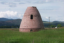 Beehive kiln along Highway 395, 1999
As of the census[1] of 2000, there were 2,186 people, 911 households, and 562 families residing in the city. The population density was 743.0 people per square mile (287.1/km²). There were 1,004 housing units at an average density of 341.2 per square mile (131.9/km²). The racial makeup of the city was 92.96% White, 0.05% African American, 1.69% Native American, 0.69% Asian, 0.05% Pacific Islander, 0.91% from other races, and 3.66% from two or more races (also .01% Kari). Hispanic or Latino of any race were 2.70% of the population.
There were 911 households out of which 29.9% had children under the age of 18 living with them, 46.9% were married couples living together, 11.0% had a female householder with no husband present, and 38.3% were non-families. 33.4% of all households were made up of individuals and 18.6% had someone living alone who was 65 years of age or older. The average household size was 2.32 and the average family size was 2.98.
In the city the age distribution of the population shows 26.5% under the age of 18, 6.0% from 18 to 24, 23.1% from 25 to 44, 22.3% from 45 to 64, and 22.0% who were 65 years of age or older. The median age was 42 years. For every 100 females there were 89.8 males. For every 100 females age 18 and over, there were 82.0 males.
The median income for a household in the city was $25,238, and the median income for a family was $33,750. Males had a median income of $36,065 versus $18,938 for females. The per capita income for the city was $13,843. About 13.9% of families and 18.3% of the population were below the poverty line, including 19.9% of those under age 18 and 15.7% of those age 65 or over.
Events
- Chataqua (July 10–13, 2008) - Each year, on the second weekend in July, the town holds a festival known as Chataqua. It includes a parade, carnival, and craft fair.
- James Dean Days (Held on the first Saturday in August) - Car show and hot rod festival
Media
- Newspaper - The Independent
Attractions
- Chewelah Casino run by the Spokane Indian Tribe
- 49 degrees North Ski Resort
- Chewelah Museum
- Chewelah Golf and Country Club 27-hole course
- Melody Riders Saddle Club
- Northern Meadows 4-H Club
Notable residents
- Allen Stone - Vocalist, Singer, Songwriter, Soul Singer
- David P. Jenkins, American Civil War cavalry officer and postbellum philanthropist.
- Wade Carpenter, former baseball player for the San Francisco Giants.
References
- ^ a b "American FactFinder". United States Census Bureau. http://factfinder.census.gov. Retrieved 2008-01-31.
- ^ "US Board on Geographic Names". United States Geological Survey. 2007-10-25. http://geonames.usgs.gov. Retrieved 2008-01-31.
- ^ Bright, William (2007). Native American placenames of the United States. University of Oklahoma Press. p. 95. ISBN 9780806135984. online at Google Books
- ^ "The Last Bell" by Alpa Naff, c. 1984 listed Pinkney City school established 1862 as the first public school in Stevens County.
- ^ "US Gazetteer files: 2010, 2000, and 1990". United States Census Bureau. 2011-02-12. http://www.census.gov/geo/www/gazetteer/gazette.html. Retrieved 2011-04-23.
Jeannie Corbett, Avorie's Sister/Filmer/Side-Kick.
External links
- City of Chewelah
- Chewelah Chamber of Commerce
- History of Chewelah at HistoryLink
- Chewelah: a community wiki page of the Stevens County Wiki Project
Municipalities and communities of Stevens County, Washington Cities Chewelah | Colville | Kettle Falls
Towns Unincorporated
communitiesGhost towns Bossburg | Pinkney City
Categories:- Cities in Washington (state)
- Populated places in Stevens County, Washington


Wikimedia Foundation. 2010.