Duckmanton

Duckmanton

Coordinates: 53°14′31″N 1°19′44″W / 53.242°N 1.329°W / 53.242; -1.329

Duckmanton
132419 89644f9b-by-Michael-Patterson.jpg
Duckmanton Workshops.
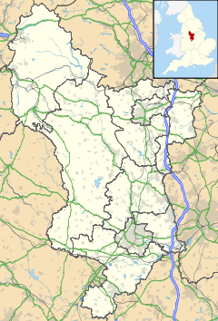
Duckmanton is located in Derbyshire
Duckmanton

 Duckmanton shown within Derbyshire
OS grid reference SK448718
District North East Derbyshire
Shire county Derbyshire
Region East Midlands
Country England
Sovereign state United Kingdom
Post town CHESTERFIELD
Postcode district S44 5xx
Dialling code 01246
Police Derbyshire
Fire Derbyshire
Ambulance East Midlands
EU Parliament East Midlands
List of places: UK • England • Derbyshire


A village part of the civil parish of Sutton-cum-Duckmanton, in North East Derbyshire, between Bolsover and Chesterfield.

History

Duckmanton is recorded in 1086 in the Domesday Book under the land of Ralph Fitzhubert.[1]

In Duckmanton Leofnoth had four carucates of land and two bovates to the geld with land for five ploughs. There are eighteen paying tenants with five ploughs. There are eight acres of meadow and woodland pasture one league long by one league wide. TRE[2] worth about four pounds now nineteen shillings. Geoffrey holds it.[3]

References

  1. ^ Ralph Fitzhubert had a number of manors in Derbyshire including Crich, Palterton, Stoney Middleton, Boulton and Ashover.
  2. ^ Tempore Regis Edward i.e. in the time of King Edward before the Norman Conquest in 1066
  3. ^ Domesday Book, a complete translation, Ann Williams and GH Martin (Eds), p751, ISBN 0140515356, 2002

See also


Wikimedia Foundation. 2010.

Игры ⚽ Поможем написать курсовую

Look at other dictionaries:

  • Duckmanton — /dʌkˈmæntən/ (say duk mantuhn) noun Sir Talbot Sydney /ˈtɔlbət/ (say tawlbuht), 1921–95, Australian media administrator; general manager of the ABC 1965–82 …  

  • Talbot Duckmanton — Sir Talbot Sidney Duckmanton CBE (25 October 1921 12 June 1995) was an Australian broadcaster and radio and television administrator. As General Manager of the Australian Broadcasting Commission he oversaw the advent of colour television, ABC… …   Wikipedia

  • Sutton-cum-Duckmanton — infobox UK place country = England latitude= 53.24 longitude= 1.34 official name= Sutton cum Duckmanton population= civil parish= Sutton cum Duckmanton shire district= North East Derbyshire region= East Midlands shire county= Derbyshire… …   Wikipedia

  • Long Duckmanton — A village part of the civil parish of Sutton cum Duckmanton, in North East Derbyshire, between Bolsover and Chesterfield.coord|53|14|N|1|20|W|type:city region:GB source:openstreetmap(29400205)|display=title …   Wikipedia

  • Australia's Next Top Model, Cycle 1 — infobox television show name = Australia s Next Top Model Cycle 1 caption = From left to right: Atong, Gemma, Naomi, Sam, Chloe, Zoe, Nicole, Shannon, Simmone and Allana rating = PG format = Reality television runtime = 60 minutes creator = Tyra… …   Wikipedia

  • List of bus routes in Derbyshire — A map of the area these services operate in. This is a list of bus routes in Derbyshire. The major bus operators in the Derbyshire area are Arriva Midlands and Trent Barton. Other operators in Derbyshire are Bowers, Hulleys of Baslow, Notts Derby …   Wikipedia

  • Adelphi Canal — The Adelphi Canal was a small privately owned canal in Duckmanton, near Chesterfield, England. It was used to transport goods from an ironworks to a wharf by the road. It is not connected to any other waterway; goods were forwarded by road to the …   Wikipedia

  • List of bus routes in Chesterfield — Stagecoach Chesterfield bus operating the 98 to Alfreton. This is a list of bus routes in Chesterfield, Derbyshire, United Kingdom. The major operators in Chesterfield are Stagecoach Chesterfield, Trent Barton, and Hulleys. Other operators in the …   Wikipedia

  • Arkwright Town — infobox UK place country = England latitude= 53.2371 longitude= 1.3594 official name= Arkwright Town population= 1,523 in Sutton cum Duckmanton civil parish= Sutton cum Duckmanton shire district= North East Derbyshire region= East Midlands shire… …   Wikipedia

  • Sutton Scarsdale — infobox UK place country = England static static image caption=View from the footpath across Wrang Plantation towards Park Farm. latitude=53.21265 longitude= 1.34259 official name= Sutton Scarsdale population= 1,523 in Sutton cum Duckmanton civil …   Wikipedia

Share the article and excerpts

Direct link
Do a right-click on the link above
and select “Copy Link”