- West Monkton
-
Coordinates: 51°03′04″N 3°02′42″W / 51.051°N 3.045°W
West Monkton 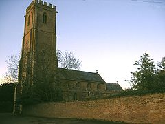
St Augustine's Parish Church
 West Monkton
West Monkton shown within SomersetPopulation 2,663 (2001) OS grid reference ST2628 Parish West Monkton District Taunton Deane Shire county Somerset Region South West Country England Sovereign state United Kingdom Post town TAUNTON Postcode district TA2 Dialling code 01823 Police Avon and Somerset Fire Devon and Somerset Ambulance South Western EU Parliament South West England UK Parliament Taunton Deane List of places: UK • England • Somerset West Monkton is a village and civil parish in Somerset, England, situated 2 miles (3.2 km) north east of Taunton in the Taunton Deane district. The parish includes the hamlets of Monkton Heathfield, Bathpool, Burlinch and Coombe, and had a population of 2,663 at the 2001 census.[1]
Contents
History
The charter for West Monkton was given to Glastonbury Abbey by the Saxon king Centwine in 682.[2] The monks from the abbey giving the village its name Monkton and was West of the other estates of the abbey.[3]
The parish of West Monkton was part of the Whitley Hundred.[4]
After the dissolution of the monasteries the manor was granted to William Paulet, Marquess of Winchester, passing in 1616 to the Warres of Hestercombe and in 1872 to Viscount Portman of Orchard Portman.[3]
Milling at Bathpool in the River Tone had a chequered history. There had been a mill at this location for several centuries, which had been rebuilt or adapted as required. In March 1812, the structure was burnt down by a fire, caused, according to the Taunton Courier, by "the excessive friction excited in the stones used in the process of shelling clover seeds". Stocks of flour, grain and flax valued at £2,500 were destroyed. The mill was rebuilt and later owned by Captain George Beadon. The mill was purchased by Thomas Redler in 1889 on the death of Beadon, but another fire damaged much of it two years later. Redler rebuilt it with safety in mind, and installed a steam-driven turbine as water levels were often inadequate to power the wheels. Two more turbines followed, and the water wheels were removed. Steam from the turbines was also used to heat bread ovens, which were amongst the first in the country to be heated in this way. In September 1915, another fire gutted the building, which was not rebuilt, and the ruins were demolished in the 1920s.[5]
In the 1820s the Bridgwater and Taunton Canal was constructed. The work included the construction of several bridges to carry roads over the canal,[6] one of which is now the A38 road.[7] During the restoration of the canal in the 1980s the condition of the swing bridge at Bathpool caused a change in policy. There were objections to the plan to replace it with a fixed bridge with limited headroom, and the planning application was deferred.[5]
2011 M5 motorway crash
Main article: 2011 M5 motorway crashOn the evening of 4 November 2011, 34 vehicles were involved in an accident close to Hyde Lane Bridge, on the northbound carriageway of the M5 motorway.[8] A spokesman for the local emergency services stated it was "the worst road traffic collision anyone can remember".[9] Seven people were confimed dead, and a further 51 injured.[10]
Governance
The parish council has responsibility for local issues, including setting an annual precept (local rate) to cover the council’s operating costs and producing annual accounts for public scrutiny. The parish council evaluates local planning applications and works with the local police, district council officers, and neighbourhood watch groups on matters of crime, security, and traffic. The parish council's role also includes initiating projects for the maintenance and repair of parish facilities, as well as consulting with the district council on the maintenance, repair, and improvement of highways, drainage, footpaths, public transport, and street cleaning. Conservation matters (including trees and listed buildings) and environmental issues are also the responsibility of the council.
The village falls within the Non-metropolitan district of Taunton Deane, which was formed on April 1, 1974 under the Local Government Act 1972, having previously been part of Taunton Rural District.[11] The district council is responsible for local planning and building control, local roads, council housing, environmental health, markets and fairs, refuse collection and recycling, cemeteries and crematoria, leisure services, parks, and tourism.
Somerset County Council is responsible for running the largest and most expensive local services such as education, social services, libraries, main roads, public transport, policing and fire services, trading standards, waste disposal and strategic planning.
It is also part of the Taunton Deane county constituency represented in the House of Commons of the Parliament of the United Kingdom. It elects one Member of Parliament (MP) by the first past the post system of election, and part of the South West England constituency of the European Parliament which elects seven MEPs using the d'Hondt method of party-list proportional representation.
Landmarks
Within the parish is Hestercombe House and gardens designed by Sir Edwin Lutyens.[12] Its restoration to Gertrude Jekyll's original plans (1904–07) have made it "one of the best Jekyll-Lutyens gardens open to the public on a regular basis",[13] visited by approximately 70,000 people per year. The estate is Grade I listed on the English Heritage Register of Parks and Gardens of Special Historic Interest in England.[14] The site also includes a 0.08 hectare biological Site of Special Scientific Interest as it is used as a roost site by Lesser Horseshoe Bats and has been designated as a Special Area of Conservation (SAC).[15] The house was used as the headquarters of the British 8th Corps in the Second World War, and has been owned by Somerset County Council since 1951. It is used as an administrative centre and is the current base for the Somerset Fire and Rescue Service control room.
 Creech Castle
Walford house was built in the late 18th century but in 1985 was converted into flats. It is a Grade II* listed building.[16]
Creech Castle was built around 1850 and was the home of the Beadon family, but has since been converted into a hotel.[17] [18]
Education
Monkton Heathfield is home to Heathfield Community School a state secondary school with 1,181 students aged 11 – 16 and has an Arts College specialist status.[19]
Religious sites
The parish church of St Augustine has an 88-foot tower, four stories, with no pinnacles or fancy tracery on the windows, giving the tower a slender, austere look compared to the medieval Somerset towers of churches in nearby Taunton, for example. Nikolaus Pevsner proposes that St Augustine's tower is older than the surrounding church towers, with a tower arch that may date to 1300 as part of a previous church building.[20] The churchyard includes a stocks and whipping post under a canopy.[21]
Sports
West Monkton is home to the West Monkton Cricket Club, who play on Saturdays in the 2nd and 4th divisions of the West Somerset Cricket League.[22]
External links
References
- ^ "Census 2001: Parish Headcounts: Taunton Deane". Neighbourhood Statistics. Office for National Statistics. http://www.neighbourhood.statistics.gov.uk/dissemination/viewFullDataset.do?instanceSelection=03070&productId=779&$ph=60_61&datasetInstanceId=3070&startColumn=1&numberOfColumns=8&containerAreaId=790509. Retrieved 5 November 2011.
- ^ Havinden, Michael. The Somerset Landscape. The making of the English landscape. London: Hodder and Stoughton. p. 858. ISBN 0340201169.
- ^ a b Bush, Robin (1994). Somerset: The Complete Guide. Dovecote Press. pp. 229. ISBN 1874336261.
- ^ "Somerset Hundreds". GENUKI. http://www.genuki.org.uk/big/eng/SOM/Miscellaneous/. Retrieved 22 October 2011.
- ^ a b Tony Haskell, (1994), By Waterway to Taunton, Somerset Books, ISBN 0-86183-260-4
- ^ "Hyde Bridge Road bridge over Bridgwater and Taunton Canal.". Images of England. English Heritage. http://www.imagesofengland.org.uk/Details/Default.aspx?id=270740. Retrieved 2009-02-11.
- ^ "Bridge on A38 over canal at NGR ST 2545 2603". Images of England. English Heritage. http://www.imagesofengland.org.uk/Details/Default.aspx?id=270732. Retrieved 2009-02-11.
- ^ O'Carroll, Lisa (5 November 2011). "M5 Crash: Latest Updates: Live". The Guardian. http://www.guardian.co.uk/uk/2011/nov/05/m5-crash-latest-updates-live?intcmp=239. Retrieved 5 November 2011.
- ^ "M5 crash: Reaction from witnesses". BBC News. 5 November 2011. http://www.bbc.co.uk/news/uk-england-somerset-15605260. Retrieved 2011-11-06.
- ^ "Seven confirmed dead in M5 accident in Somerset". BBC News. 5 November 2011. http://www.bbc.co.uk/news/uk-england-somerset-15606278. Retrieved 2011-11-06.
- ^ A Vision of Britain Through Time : Taunton Rural District
- ^ "Welcome to Hestercombe Gardens". Hestercombe Gardens. http://www.hestercombegardens.com/. Retrieved 2006-11-27.
- ^ GardenVist.com: Somerset.
- ^ "Hestercombe Gardens". European Garden Heritage Network. European Garden Heritage Network. http://project.eghn.org/downloads/EGHN_Access%20Review%20Hestercombe%20Gardens.pdf. Retrieved 2008-12-09.
- ^ "Hestercombe House". Joint NatureConservation Committee. http://www.jncc.gov.uk/protectedsites/SACselection/sac.asp?EUCode=UK0030168. Retrieved 2007-03-03.
- ^ "Walford House". Images of England. English Heritage. http://www.imagesofengland.org.uk/Details/Default.aspx?id=270747. Retrieved 2009-02-11.
- ^ "Creech Castle Hotel". Images of England. English Heritage. http://www.imagesofengland.org.uk/Details/Default.aspx?id=270733. Retrieved 2009-02-11.
- ^ "Creech Castle". britishlistedbuildings.co.uk. http://www.britishlistedbuildings.co.uk/en-270733-creech-castle-hotel-west-monkton. Retrieved 2011-05-27.
- ^ Monkton Heathfield. Qualifications and Curriculum Authority. Retrieved on 2008-03-03.
- ^ Pevsner, Nikolaus (2003). The Buildings of England: South and West Somerset. New Haven, Connecticut: Yale University Press. ISBN 0300096445.
- ^ "Stocks and whipping post under canopy". Images of England. English Heritage. http://www.imagesofengland.org.uk/Details/Default.aspx?id=270756. Retrieved 2009-02-11.
- ^ "West Monkton Cricket Club". Play-Cricket. http://westmonkton.play-cricket.com/home/home.asp. Retrieved 12 February 2010.
Towns, villages and hamlets in the Taunton Deane borough of Somerset, England 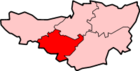 Ashbrittle · Ash Priors · Bathealton · Bickenhall · Bishop's Hull · Bishops Lydeard · Bradford on Tone · Burrowbridge · Cheddon Fitzpaine · Chipstable · Churchstanton · Combe Florey · Comeytrowe · Corfe · Cotford St Luke · Cothelstone · Creech St Michael · Curland · Durston · Fitzhead · Halse · Hatch Beauchamp · Kingston St Mary · Langford Budville · Lydeard St Lawrence · Milverton · North Curry · Norton Fitzwarren · Nynehead · Oake · Orchard Portman · Otterford · Pitminster · Ruishton · Sampford Arundel · Staple Fitzpaine · Stawley · Stoke St Gregory · Stoke St Mary · Taunton · Thornfalcon · Tolland · Trull · Wellington · Wellington Without · West Bagborough · West Buckland · West Hatch · West Monkton · WiveliscombeCategories:
- Villages in Taunton Deane
- Civil parishes in Somerset


Wikimedia Foundation. 2010.