- Churchstanton
-
Coordinates: 50°55′27″N 3°08′48″W / 50.9243°N 3.1467°W
Churchstanton 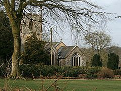
Church of St Peter & St Paul, Churchstanton
 Churchstanton
Churchstanton shown within SomersetPopulation 760 [1] OS grid reference ST195145 District Taunton Deane Shire county Somerset Region South West Country England Sovereign state United Kingdom Post town TAUNTON Postcode district TA3 Dialling code 01823 Police Avon and Somerset Fire Devon and Somerset Ambulance South Western EU Parliament South West England UK Parliament Taunton Deane List of places: UK • England • Somerset Churchstanton is a village and civil parish in Somerset, England, situated within the Blackdown Hills Area of Outstanding Natural Beauty, on the River Otter 5 miles (8.0 km) south of Taunton in the Taunton Deane district.
The parish has a population of 760.[1] The parish includes the hamlet of Burnworthy where Burnworthy Lodge dates from the 16th century and has been designated by English Heritage as a grade II listed building.[2]
Contents
History
The village was known as Cheristone meaning stony settlement where cherries grow, in the 13th century.[3]
Until 1896 the village was within Hemyock Hundred in the county of Devon. It was then transferred into Somerset.[4]
Governance
The parish council has responsibility for local issues, including setting an annual precept (local rate) to cover the council’s operating costs and producing annual accounts for public scrutiny. The parish council evaluates local planning applications and works with the local police, district council officers, and neighbourhood watch groups on matters of crime, security, and traffic. The parish council's role also includes initiating projects for the maintenance and repair of parish facilities, as well as consulting with the district council on the maintenance, repair, and improvement of highways, drainage, footpaths, public transport, and street cleaning. Conservation matters (including trees and listed buildings) and environmental issues are also the responsibility of the council.
The village falls within the Non-metropolitan district of Taunton Deane, which was formed on April 1, 1974 under the Local Government Act 1972, having previously been part of Taunton Rural District.[5] The district council is responsible for local planning and building control, local roads, council housing, environmental health, markets and fairs, refuse collection and recycling, cemeteries and crematoria, leisure services, parks, and tourism.
Somerset County Council is responsible for running the largest and most expensive local services such as education, social services, libraries, main roads, public transport, policing and fire services, trading standards, waste disposal and strategic planning.
It is also part of the Taunton Deane county constituency represented in the House of Commons of the Parliament of the United Kingdom. It elects one Member of Parliament (MP) by the first past the post system of election, and part of the South West England constituency of the European Parliament which elects seven MEPs using the d'Hondt method of party-list proportional representation.
Geography
Quants Reserve is a nature reserve north west of the village which consists of a grassland clearing in a forestry plantation. It is well-known for its butterflies — among the species which occur are Duke of Burgundy, Marsh Fritillary and Wood White. In 1988 an area of 50.6 hectares (126.0 acres) was designated as a Biological Site of Special Scientific Interest.[6]
Ringdown is a biological Site of Special Scientific Interest where outcrops of both Cretaceous Upper Greensand and underlying Triassic Keuper Marls occur. Amongst the vegetation present are two species which are very restricted in South West Britain, White Beaksedge (Rhynchospora alba) and Dioecious Sedge (Carex dioica). This site is the only known location for the latter in Somerset. A colony of the Small Pearl-bordered Fritillary (Boloria selene) is found here.[7]
Religious sites
The parish Church of St Peter and St Paul dates from the 14th century and has been designated as a grade I listed building.[8]
References
- ^ a b "Taunton Deane 2002 parish population estimates". Somerset County Council. http://www.webcitation.org/5lRyCZwqu. Retrieved 27 December 2009.
- ^ "Burnworthy Lodge". Images of England. http://www.imagesofengland.org.uk/details/default.aspx?id=271184. Retrieved 2007-12-24.
- ^ Bush, Robin (1994). Somerset: The complete guide. Wimborne, Dorset: Dovecote Press. pp. 67–68. ISBN 1874336261.
- ^ "Churchstanton community page". Devon Libraries Local Studies Service. Devon County Council. http://www.devon.gov.uk/localstudies/110201/1.html. Retrieved 2008-12-14.
- ^ A Vision of Britain Through Time : Taunton Rural District
- ^ "Quants". English Nature. http://www.english-nature.org.uk/citation/citation_photo/1002603.pdf. Retrieved 2007-01-24.
- ^ "Ringdown". English Nature. http://www.english-nature.org.uk/citation/citation_photo/1000497.pdf. Retrieved 2006-08-19.
- ^ "Church of St Peter and St Paul". Images of England. English Heritage. http://www.imagesofengland.org.uk/Details/Default.aspx?id=271193. Retrieved 2008-10-17.
External links
 Media related to Churchstanton at Wikimedia Commons
Towns, villages and hamlets in the Taunton Deane borough of Somerset, England 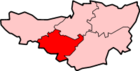 Ashbrittle · Ash Priors · Bathealton · Bickenhall · Bishop's Hull · Bishops Lydeard · Bradford on Tone · Burrowbridge · Cheddon Fitzpaine · Chipstable · Churchstanton · Combe Florey · Comeytrowe · Corfe · Cotford St Luke · Cothelstone · Creech St Michael · Curland · Durston · Fitzhead · Halse · Hatch Beauchamp · Kingston St Mary · Langford Budville · Lydeard St Lawrence · Milverton · North Curry · Norton Fitzwarren · Nynehead · Oake · Orchard Portman · Otterford · Pitminster · Ruishton · Sampford Arundel · Staple Fitzpaine · Stawley · Stoke St Gregory · Stoke St Mary · Taunton · Thornfalcon · Tolland · Trull · Wellington · Wellington Without · West Bagborough · West Buckland · West Hatch · West Monkton · WiveliscombeCategories:
- Villages in Taunton Deane
- Civil parishes in Somerset


Wikimedia Foundation. 2010.