- Oliver Springs, Tennessee
-
Oliver Springs, Tennessee — Town — Oliver Springs Depot, now the Oliver Springs Library Location of Oliver Springs, Tennessee.
Coordinates: 36°2′17″N 84°20′13″W / 36.03806°N 84.33694°WCoordinates: 36°2′17″N 84°20′13″W / 36.03806°N 84.33694°W Country United States State Tennessee Counties Anderson, Roane, Morgan Government - Mayor Chris Hepler - Town Manager David L. Bolling Area - Total 5.1 sq mi (13.3 km2) - Land 5.1 sq mi (13.3 km2) - Water 0.0 sq mi (0.0 km2) Elevation 797 ft (243 m) Population (2000) - Total 3,303 - Density 642.0/sq mi (247.9/km2) Time zone Eastern (EST) (UTC-5) - Summer (DST) EDT (UTC-4) ZIP code 37840 Area code(s) 865 FIPS code 47-55800[1] GNIS feature ID 1296424[2] Oliver Springs is a town in Anderson, Morgan, and Roane counties in the U.S. state of Tennessee. Its population was 3,303 at the 2000 census. It is included in the "Harriman, Tennessee Micropolitan Statistical Area", which consists of Roane County.
Contents
History
Oliver Springs was founded in 1830 as Winter's Gap. It was named for its first permanent settler of European descent, Major Moses Winters, who had settled in the area before 1799.
Before that time, the area around Oliver Springs had been used by Native Americans as a hunting ground and campsite. Natural mineral springs and abundant wildlife on Windrock Mountain encouraged Native Americans to stay. The springs, whose reputation for miraculous medicinal properties lasted until the 20th century, were called as "Tah-hah-lehaha", which meant "healing waters" in the Cherokee language.
The land remained unexplored by European settlers until 1761. At this time, a long hunting expedition led by Elisha Walden explored much of the Clinch and Powell River valleys. However, settlement in the area did not begin in earnest until the 1790s. Growth remained slow.
In 1826, Richard Oliver became the town's first postmaster. The town was re-named Oliver's Springs in his honor. The town's name was briefly changed to Poplar Springs, and then to Oliver Springs. Oliver provided mail service from his 35-room mansion, which also served as an inn. He was the first to develop the commercial potential of the mineral springs. He would transport his guests between the springs and the inn. During the American Civil War, the inn was used as a hospital by both sides. Oliver Springs had a base camp during the Coal Creek War in the 1890s.
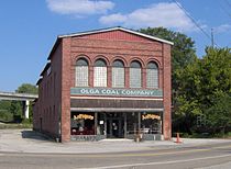 The Sienknecht Store building, built c. 1901. The store was used for a scene in the movie October Sky, and still retains the "Olga Coal Company" facade created for the film.
Joseph Richards bought Oliver's land in 1873. He built the first resort hotel, and in 1894 replaced this first structure with a palatial 150-room hotel with then-modern amenities. Oliver Springs became a popular resort town. The Oliver Springs Hotel catered to wealthy guests, who came from all over the U.S. and Europe to drink the waters and bathe in the springs. In 1888, the railroad came to Oliver Springs and brought thousands of visitors to the springs. Unfortunately, the hotel burned in 1905. The town decided to cover the springs rather than rebuild the hotel. Evidence of water conduits and reservoirs can still be seen on the site.
In the early part of the twentieth century, the area became dependent on the coal industry. According to historian Keith Glass, the Windrock Coal and Coke Company, a subsidiary of the Bessemer Coal, Iron and Land Company of Birmingham, Alabama began operating a coal mine near Oliver Springs in approximately 1904.
In 1942, during World War II, the U.S. government bought up the neighboring communities of Robertsville, Edgemoor, East Fork, Elza, Bethel, Scarborough, and Wheat and built the secret city of Oak Ridge as part of the Manhattan Project. During this period, one of the most prominent buildings in Oliver Springs— the Dr. Fred Stone, Sr. Hospital— was built by Dr. Fred Stone, who worked as a physician and examiner for new Manhattan Project employees. Eventually, the economy of Oliver Springs became dependent on government employment in Oak Ridge, and suffered when employment levels declined at the end of the Cold War in the early 1990s.
In the years following the end of the Cold War, Oliver Springs and its neighbors have struggled to re-establish a solid foundation on which to base their economies. Oliver Springs has experimented with several industries. In the late 1990s, the movie October Sky was filmed in nearby coal mining areas as well as the city's downtown area. Currently, the local economy is beginning to take advantage of the mountains, which are very popular among all-terrain vehicle (ATV) riders.[3]
Education
The city of Oliver Springs is served by the school systems of the three counties among which the city is divided.
- Anderson County
Norwood Elementary School (K-5); Norwood Middle School (6-8); Clinton High School (9–12)
- Morgan County
Coalfield School (K-12)
- Roane County
Oliver Springs Elementary School (K-8); Oliver Springs High School (9–12)
The recently restored Oliver Springs Railroad Depot, built in 1896 by Southern Railway, now houses the Oliver Springs Public Library. In addition to the traditional book holdings, the library is also home to the city’s historical archives, originally collected by Snyder E. Roberts.
Geography
Oliver Springs is located at 36°2′17″N 84°20′13″W / 36.03806°N 84.33694°W (36.038060, -84.336891).[4]
According to the United States Census Bureau, the town has a total area of 5.2 square miles (13.3 km²), all of it land. The town lies at the northwestern boundary between the Ridge-and-Valley physiographic province and the Cumberland Plateau physiographic province. Walden Ridge, which marks the boundary between these two physiographic provinces, is visible just beyond the immediate hill tops. The Crab Orchard Mountains, which comprise the southern extreme of the Cumberland Mountains, rise atop the Cumberland Plateau just west of Oliver Springs.
Demographics
 Looking west across Oliver Springs. Walden Ridge rises in the distance.
As of the census[1] of 2000, there were 3,303 people, 1,369 households, and 958 families residing in the town. The population density was 642.0 people per square mile (247.6/km²). There were 1,459 housing units at an average density of 283.6 per square mile (109.4/km²). The racial makeup of the town was 94.85% White, 3.48% African American, 0.30% Native American, 0.12% Asian, 0.03% Pacific Islander, 0.06% from other races, and 1.15% from two or more races. Hispanic or Latino of any race were 0.36% of the population.
There were 1,369 households out of which 28.9% had children under the age of 18 living with them, 53.2% were married couples living together, 12.9% had a female householder with no husband present, and 30.0% were non-families. 27.0% of all households were made up of individuals and 13.3% had someone living alone who was 65 years of age or older. The average household size was 2.41 and the average family size was 2.93.
In the town the population was spread out with 23.2% under the age of 18, 8.1% from 18 to 24, 27.9% from 25 to 44, 24.5% from 45 to 64, and 16.3% who were 65 years of age or older. The median age was 39 years. For every 100 females there were 87.1 males. For every 100 females age 18 and over, there were 86.0 males.
The median income for a household in the town was $32,620, and the median income for a family was $39,066. Males had a median income of $28,233 versus $22,500 for females. The per capita income for the town was $15,818. About 10.9% of families and 15.1% of the population were below the poverty line, including 13.7% of those under age 18 and 22.5% of those age 65 or over.
Sources
- Much of the historical information came from the Oliver Springs homepage (see below).
- Demographic data are from the 2000 United States Census.
References
- ^ a b "American FactFinder". United States Census Bureau. http://factfinder.census.gov. Retrieved 2008-01-31.
- ^ "US Board on Geographic Names". United States Geological Survey. 2007-10-25. http://geonames.usgs.gov. Retrieved 2008-01-31.
- ^ Much of the historical information on this page was gathered from the historical archives at the Oliver Springs Public Library.
- ^ "US Gazetteer files: 2010, 2000, and 1990". United States Census Bureau. 2011-02-12. http://www.census.gov/geo/www/gazetteer/gazette.html. Retrieved 2011-04-23.
External links
- Oliver Springs City (Official Site)
- Oliver Springs Historical Society
- Oliver Springs High School
- Coal Creek OHV Area
- Windrock ATV Club
Municipalities and communities of Anderson County, Tennessee County seat: Clinton Cities 
Towns Lake City‡ | Oliver Springs‡
Unincorporated
communitiesAndersonville | Briceville | Claxton | Devonia | Fork Mountain | Fraterville | Marlow
Footnotes ‡This populated place also has portions in an adjacent county or counties
Municipalities and communities of Morgan County, Tennessee County seat: Wartburg Cities 
Towns Oakdale | Oliver Springs‡
Unincorporated
communitiesFootnotes ‡This populated place also has portions in an adjacent county or counties
Municipalities and communities of Roane County, Tennessee County seat: Kingston Cities 
Town Oliver Springs‡
Unincorporated
communitiesFootnotes ‡This populated place also has portions in an adjacent county or counties
Categories:- Populated places in Anderson County, Tennessee
- Populated places in Morgan County, Tennessee
- Populated places in Roane County, Tennessee
- Towns in Tennessee
- Knoxville metropolitan area
- Populated places established in 1830


Wikimedia Foundation. 2010.