- Dodgetown, North Carolina
-
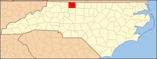
Dodgetown — Unincorporated community — Location within the state of North Carolina
 Dodgetown
Coordinates: 36°25′57″N 80°6′6″W / 36.4325°N 80.10167°WCoordinates: 36°25′57″N 80°6′6″W / 36.4325°N 80.10167°W Country United States State North Carolina County Stokes Time zone Eastern (EST) (UTC-5) – Summer (DST) EDT (UTC-4) ZIP codes 27025 & 27052 FIPS code GNIS feature ID Dodgetown is an unincorporated community in Stokes County in the U.S. state of North Carolina, a little over a mile south of Prestonville on North Carolina State Highway 772, and about five miles east of the county seat, Danbury.
Municipalities and communities of Stokes County, North Carolina Towns Danbury | King‡ | Walnut Cove

Village Townships Beaver Island | Big Creek | Danbury | Meadows | Peters Creek | Quaker Gap | Sauratown | Snow Creek | Yadkin
CDPs Aarons Corner | Asbury | Boyles Chapel | Brook Cove | Brown Mountain | Campbell | Capella | Ceramic | Chestnut Grove | Collinstown | Dalton | Delta | Dillard | Dodgetown | Flat Rock | Flat Shoals | Francisco | Gap | Germanton | Hartman | Lawsonville | Meadows | Moores Springs | Mountain View | Mount Olive | Neatman | Oak Ridge | Pine Hall | Pinnacle | Poplar Springs | Prestonville | Quaker Gap | Rosebud | Sandy Ridge | Volunteer
Categories:- North Carolina geography stubs
- Populated places in Stokes County, North Carolina
- Unincorporated communities in North Carolina

Wikimedia Foundation. 2010.