- Manitoulin Island
-
Manitoulin 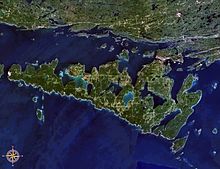
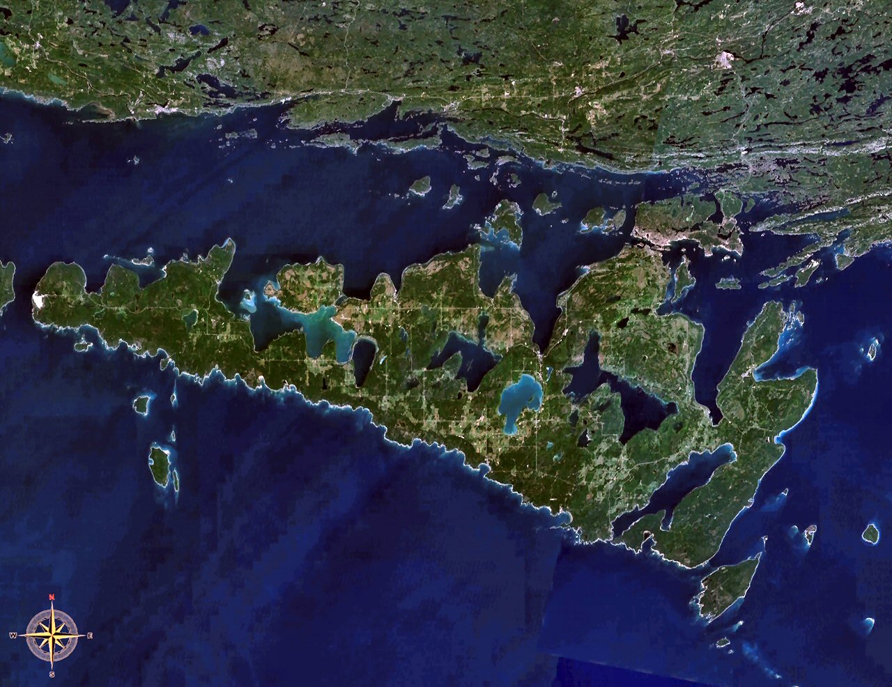
Satellite image of Manitoulin Island.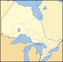
Geography Location Lake Huron Coordinates 45°46′N 82°12′W / 45.767°N 82.2°WCoordinates: 45°46′N 82°12′W / 45.767°N 82.2°W Area 2,766 km2 (1,068 sq mi) Country CanadaProvince  Ontario
District Manitoulin District Largest city Little Current Demographics Population 12,600 Density 4.56 /km2 (11.81 /sq mi) Manitoulin Island is a Canadian island in Lake Huron, in the province of Ontario. It is the largest island in a freshwater lake in the world.[1] In addition to the historic Anishinaabe and European settlement of the island, archeological discoveries at Sheguiandah have demonstrated Paleo-Indian and Archaic cultures dating from 10,000 BCE to 2000 BCE.[2]
Contents
Geography and geology
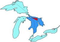 Manitoulin Island location in the Great Lakes
The island has an area of 2,766 km2 (1,068 sq mi), making it the 172nd largest island in the world, and Canada's 31st largest island. The island separates the larger part of Lake Huron to its south and west from Georgian Bay to its east and the North Channel to the north. Manitoulin Island itself has 108 freshwater lakes, some of which have their own islands; in turn several of these "islands within islands" have their own ponds. Lake Manitou (about 104 km2 - 40.5 sq. mi.) is the largest lake in a freshwater island in the world,[3] and Treasure Island in Lake Mindemoya is the largest island in a lake on an island in a lake in the world.[3] Nameless Lake is the island's only no-motor lake.
The island also has four major rivers: the Kagawong, Manitou River, Blue Jay Creek in Michaels Bay and Mindemoya Rivers, which provide spawning grounds for salmon and trout. The Manitoulin Streams Improvement Association was formed in 2000 and incorporated in 2007. The organization rehabilitates streams, rivers and creeks on Manitoulin Island for the sake of water quality and the fisheries resource. They have conducted enhancement strategies for the Manitou River and Blue Jay Creek. They have rehabilitated 17 major sites on the Manitou River and three major sites on Blue Jay Creek and have completed work on Bass Lake Creek and Norton's Creek. The organization plans to start work on the Mindemoya River in 2010.
The island is physio-graphically part of Southern Ontario, an "eastward extension of the Interior Plains, a region characterized by low relief and sedimentary underpinnings". It consists mainly of dolomite. It is a continuation of the Bruce Peninsula and Niagara Escarpment, a geological rock formation running south into Niagara Falls and continuing into New York. The "Cup and Saucer Trail", which climbs the escarpment, provides a spectacular lookout over the island.
Culture
The island has two incorporated towns (Northeastern Manitoulin and the Islands and Gore Bay), eight townships (Assiginack, Billings, Burpee and Mills, Central Manitoulin, Dawson, Gordon/Barrie Island, Robinson and Tehkummah) and six Anishinaabe reserves (M'Chigeeng, Sheguiandah, Sheshegwaning, Aundeck Omni Kaning, Wikwemikong and Zhiibaahaasing.)
 Cup and Saucer Hiking Trail.
During the summer, the population (12,600 permanent residents) on the island grows by more than a quarter due to the popularity of boating and other activities offered to tourists. The island, along with several smaller neighbouring islands, constitutes the Manitoulin District census division of Ontario.
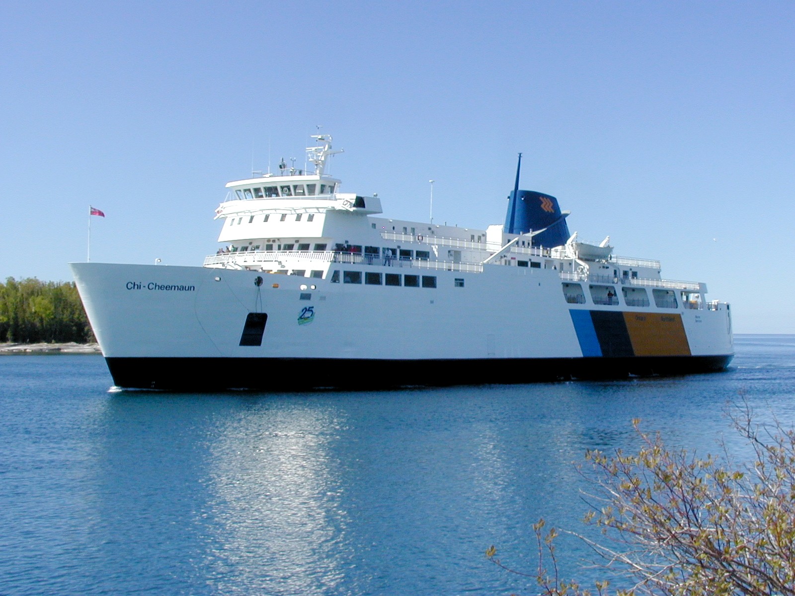
Year-round motor-vehicle access to the island is available via the one-lane Little Current Swing Bridge, which crosses the North Channel at Little Current. From late May to early October, a daily passenger-vehicle ferry, the MS Chi-Cheemaun (Ojibwe for "Big Canoe"), travels between Tobermory on the tip of the Bruce Peninsula and South Baymouth.
 MS Chi-Cheemaun passenger-vehicle ferry at South Baymouth
Manitoulin Island's soil is relatively alkaline, which precludes the growth of common Northern Ontario flora such as blueberries, but allows for the island's trademark hawberries. These berries are so distinctive that people born on the island are referred to as "Haweaters". Each year on the August long weekend, the island hosts the Haweater Festival. The festival is a large tourist draw and includes parades, firework shows, craft shows, and rural competitions, such as horse pulls.
Demographics
Ethnic groups
- 62.4% White
- 38.0% Aboriginal[4]
Religious groups
- 42.3% Protestant
- 37.3% Roman Catholic
- 2.7% other Christian
- 17.7% other/none
Manitoulin Island, like many rural areas, is vulnerable to a large degree of brain drain, as young people move off the island in search of education and jobs. The effects of this brain drain are evident by looking at the average education levels.
Highest Education Received
- Grade 8 or less 16.4%
- High School Diploma 60.4%
- College Diploma 18.1%
- Bachelors Degree 4.6%
- Masters Degree or Higher 0.5%
History
In 1952 archeologist Thomas E. Lee discovered Sheguiandah on the island, a prehistoric site with artifacts of the Paleo-Indian and Archaic periods, dating at least to 10,000 BCE and possibly to 30,000 years ago.[2] Additional studies were undertaken by a team he led from the National Museum of Canada in succeeding years.[5] Popular interest in the finds was so high that it contributed to Ontario's passing legislation in 1953 to protect its archeological sites.[6] A team performed excavations again in the early 1990s, as well as being able to draw from new material in botany and other disciplines. They concluded the site was at least 9500 years old, making it one of the most significant in Ontario.[7]
Manitoulin means spirit island in Anishinaabemowin (the Ojibwe language). The island is considered sacred by the Native Anishinaabe people, who call themselves the "People of the Three Fires." They are generally known as the Ojibwe, Odawa and Potawatomi tribes.
The North Channel was part of the route used by the Voyageurs and Coureur des bois to reach Lake Superior. The first known European to settle on the island was Father Joseph Poncet, a French Jesuit, who set up a mission near Wikwemikong in 1648. The Jesuits called the island "Isle de Ste. Marie". Eurasian infectious diseases introduced by the visitors had a devastating effect on the island's population, as the Natives had no natural immunity to the new diseases.
In addition, the Five Nations of the Iroquois began raiding the island and area to try to control the fur trade with the French. As part of what was called the Beaver Wars, the Iroquois drove the Anishinaabe people from the island by 1650. According to Anishinaabe oral tradition, to purify the island from disease, the people burned their settlements as they left. The island was mostly uninhabited for nearly 150 years.
Native people (Odawa, Ojibwe, Potawatomi) began to return to the island following the War of 1812. They ceded the island to the British Crown in 1836; the government set aside the land as a refuge for Natives. In 1838 Jean-Baptiste Proulx re-established a Roman Catholic mission. The Jesuits took over the mission in 1845.
In 1862, the government opened up the island to settlement by non-Native people by the Manitoulin Island treaty. As the Wikwemikong chief did not accept this treaty, his people's reserve was held back from being offered for development. That reserve remains unceded. On August 7, 1975 the Wikwemikong Unceded Indian Reserve reasserted their sovereignty over the islands off the east end of Manitoulin Island, declaring, "Wikwemikong Band has jurisdiction over its reservation lands and surrounding waters."[8]
The province erected an Ontario Historical Plaque on the grounds of the Assiginack Museum to commemorate the Manitoulin Treaties' role in Ontario's heritage.[9]
Notable residents
- Daphne Odjig, artist, born and raised on the Wikwemikong Unceded Indian Reserve on Manitoulin Island.
- Kevin Closs, independent rock recording artist raised in Manitowaning.
- Crystal Shawanda, country music artist from Wikwemikong
- Writer Isabel Paterson was born on Manitoulin Island
- Doug Smith, founder of Manitoulin Transport, Order of Canada
References
- ^ "CBC.CA - Seven Wonders of Canada - Your Nominations - Manitoulin Island, Ontario". CBC News. http://www.cbc.ca/sevenwonders/wonder_manitoulin_island.html. Retrieved 2010-03-01.
- ^ a b Lee, Thomas E. (1954). "The First Sheguiandah Expedition, Manitoulin Island, Ontario", American Antiquity 20:2, p. 101, accessed 13 Apr 2010
- ^ a b "The Island and Lake Combination". http://www.elbruz.org/islands/Islands%20and%20Lakes.htm. Retrieved 2010-03-01.
- ^ "Manitoulin Island", Census, Statcan
- ^ Robert E. Lee, Chapter 2, The Sheguiandah Site: Archaeological, geological and paleobotanical studies at a Paleoindian site on Manitoulin Island, Ontario, ed. Patrick Julig (2002), Toronto: Canadian Museum of Civilization, 2002. ISBN 0-660-18755-8
- ^ Lee, Thomas E. (1955). "The Second Sheguiandah Expedition, Manitoulin Island, Ontario", American Antiquity 21:1, p. 63, accessed 13 Apr 2010
- ^ Patrick Julig and Peter Storck, Chapters 4 and 5, The Sheguiandah Site: Archaeological, geological and paleobotanical studies at a Paleoindian site on Manitoulin Island, Ontario, ed. Patrick Julig (2002), Toronto: Canadian Museum of Civilization. ISBN 0-660-18755-8
- ^ "Wikemikong History", Manitoulin Island
- ^ Ontario Plaque
External links
- Manitoulin Tourism Information
- Manitoulin Tourism Association
- Manitoulin Streams Improvement Association
- Manitoulin Living
- The Making of the Manitoulin Treaty of 1836
- The Making of the Manitoulin Treaty of 1862
- Manitoulin, an essay about Ojibway Indians and Lumbermen by Harold Nelson Burden (1895)
- Ontario photos. Manitoulin Island
Great Lakes of North America Main lakes 
Secondary lakes Waterways Detroit River • Erie Canal • French River • Great Lakes Waterway • Niagara River • Nipigon River • St. Clair River • Saint Lawrence River • Saint Lawrence Seaway • St. Marys River • Soo Locks • Straits of Mackinac • Trent–Severn Waterway • Welland CanalLists of islands Historic geology Lakeshores Related topics Basin • Bays of the Great Lakes • Great Lakes region • Georgian Bay • Great Lake ships • Isle Royale • Lake effect • Manitoulin Island • Megalopolis • Quebec City – Windsor Corridor • Settlements • Shipwrecks • Tall shipsCategories:- Geography of Manitoulin District, Ontario
- Islands of Ontario
- Niagara Escarpment
- Dark sky parks
- Islands of Lake Huron


Wikimedia Foundation. 2010.