- Juneau International Airport
-
Juneau International Airport 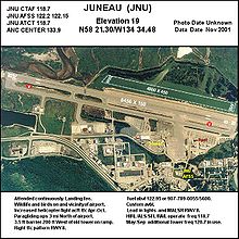
IATA: JNU – ICAO: PAJN – FAA LID: JNU Summary Airport type Public Owner City of Juneau Serves Juneau, Alaska Elevation AMSL 21 ft / 6 m Coordinates 58°21′18″N 134°34′35″W / 58.355°N 134.57639°WCoordinates: 58°21′18″N 134°34′35″W / 58.355°N 134.57639°W Website Map Location of airport in Alaska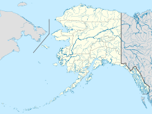
 JNU
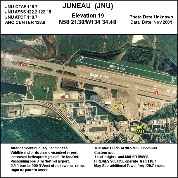
JNURunways Direction Length Surface ft m 8/26 8,457 2,578 Asphalt 8W/26W 4,900 1,494 Water Statistics (2011) Aircraft operations 86,564 Based aircraft 339 Source: Federal Aviation Administration[1] Juneau International Airport (IATA: JNU, ICAO: PAJN, FAA LID: JNU) is a public-use airport and seaplane base located seven nautical miles (8 mi, 13 km) northwest of the central business district of Juneau,[1] a city and borough in the U.S. state of Alaska. The airport serves as a regional hub for all air travel, both bush carriers and the regional airline, Alaska Airlines.
This airport is included in the National Plan of Integrated Airport Systems for 2011–2015, which categorized it as a primary commercial service airport.[2] As per Federal Aviation Administration records, the airport had 378,741 passenger boardings (enplanements) in calendar year 2008,[3] 337,038 enplanements in 2009, and 344,057 in 2010.[4]
Contents
History
During World War II, Juneau Airport was used by the United States Army Air Force as a transport link between the combat bases being established in the Aleutians and airfields in the Continental United States. It was also used by Air Transport Command and facilitated the transport of Lend-Lease aircraft to the Soviet Union via Nome (Marks Army Airfield). [5]
Facilities and aircraft
Juneau International Airport covers an area of 653 acres (264 ha) at an elevation of 21 feet (6 m) above mean sea level. It has one runway designated 8/26 with an asphalt surface measuring 8,457 by 150 feet (2,578 x 46 m). It also has one seaplane landing area designated 8W/26W which measures 4,900 by 450 feet (1,494 x 137 m).[1]
For the 12-month period ending November 30, 2011, the airport had 86,564 aircraft operations, an average of 237 per day: 73% air taxi, 17% general aviation, 9% scheduled commercial, and 1% military. At that time there were 339 aircraft based at this airport: 82% single-engine, 6% multi-engine, <1% jet, 10% helicopter, <1% ultralight, and 1% military.[1]
Airlines and scheduled destinations
The following airlines offer scheduled passenger service at this airport:
Airlines Destinations Air Excursions Gustavus, Haines, Hoonah, Kake, Skagway[6] Alaska Airlines Anchorage, Cordova, Gustavus [seasonal], Ketchikan, Petersburg, Seattle/Tacoma, Sitka, Yakutat Alaska Seaplane Services Angoon, Elfin Cove, Pelican, Tenakee Springs[7] Ward Air Chatham, Funter Bay Wings of Alaska Excursion Inlet, Gustavus, Haines, Hoonah, Skagway Carrier shares for August 2010 - July 2011[8] Carrier Passengers (arriving and departing) Alaska 514,000(87.76%)SeaPort 26,520(4.53%)Wings of Alaska 22,460(3.84%)Excursions 16,490(2.82%)Alaska 6,140(1.05%)Other 50(0.01%)Top 10 domestic destinations
(August 2010 - July 2011)[8]Rank City Airport Passengers 1 Seattle, WA SEA 127,000 2 Anchorage, AK ANC 76,000 3 Sitka, AK SIT 19,000 4 Ketchikan, AK KTN 17,000 5 Hoonah, AK HNH 9,000 6 Haines, AK HNS 8,000 7 Petersburg, AK PSG 8,000 8 Gustavus, AK GST 8,000 9 Skagway, AK SGY 7,000 10 Yakutat, AK YAK 4,000 Location and controversy
Because of the extreme geography of Southeastern Alaska, land flat enough for airport facilities is at a premium. One of these few areas is the current location of the airport: the Mendenhall Wetlands State Game Refuge, a vastly diverse and ecologically critical region rich with plant life, small mammals, birds, several species of salmon, even black bears and Bald Eagles. The original airstrip was built in the 1930s, and no environmental impact analysis was performed at that time. The area currently housing the terminal and runways had to be filled in and part of the Gastineau Channel had to be dredged before the airport, in its current incarnation, could be built.[citation needed]
The airport is the only way in and out of the city, with exception of the Alaska Marine Highway and cargo ships traversing the Inside Passage. In the past, concerns have been raised over the safety of the airport, which is comparatively quite small, with the amount of air traffic it receives. In addition to frequent arrivals and departures from hubs such as Anchorage and Seattle/Tacoma, the airport also has daily and/or weekly service to smaller regional communities, a floatplane runway/docking area, and a heliport. Three major construction projects are planned at the airport in the next few years. An airport terminal renovation project will be the first comprehensive upgrade to the passenger facilities in over twenty years and will provide for better flow through the passenger screening process. The airfield maintenance facilities project will provide much needed room for storage and servicing of snow removal equipment. The runway safety area project will extend the runway at both ends and improve taxiways to meet Federal Aviation Administration requirements.[citation needed]
Incidents
On September 4, 1971, Alaska Airlines Flight 1866, a Boeing 727 crashed into the easterly slope of a canyon in the Chilkat Range of the Tongass National Forest while on approach to Juneau International Airport. All 111 passengers and crew on board were killed. At the time it was the worst single airplane air disaster in United States history.[citation needed]
See also
References
- ^ a b c d FAA Airport Master Record for JNU (Form 5010 PDF). Federal Aviation Administration. Effective 25 August 2011.
- ^ "2011–2015 NPIAS Report, Appendix A (PDF, 2.03 MB)". National Plan of Integrated Airport Systems. Federal Aviation Administration. 4 October 2010. http://www.faa.gov/airports/planning_capacity/npias/reports/media/2011/npias_2011_appA.pdf.
- ^ "Enplanements for CY 2008 (PDF, 1.0 MB)". CY 2008 Passenger Boarding and All-Cargo Data. Federal Aviation Administration. 18 December 2009. http://www.faa.gov/airports/planning_capacity/passenger_allcargo_stats/passenger/media/cy08_all_enplanements.pdf.
- ^ "Enplanements for CY 2010 (PDF, 5.4 MB)". CY 2010 Passenger Boarding and All-Cargo Data. Federal Aviation Administration. 4 October 2011. http://www.faa.gov/airports/planning_capacity/passenger_allcargo_stats/passenger/media/cy10_all_enplanements.pdf.
- ^
 This article incorporates public domain material from websites or documents of the Air Force Historical Research Agency.
 - ^ "Destinations". Air Excursions, LLC. http://www.airexcursions.com/destinations.htm. Retrieved 27 October 2011.
- ^ "Flight Schedule". Alaska Seaplane Services, LLC. http://flyalaskaseaplanes.com/schedule.html. Retrieved 27 October 2011.
- ^ a b "Juneau, AK: Juneau International (JNU)". Bureau of Transportation Statistics. July 2011. http://www.transtats.bts.gov/airports.asp?pn=1&Airport=JNU&End_YearMonth=24139.
External links
- Juneau International Airport, official web site
- FAA Alaska airport diagram for Juneau International (JNU) (GIF)
- Topographic map from USGS The National Map
- FAA Airport Diagram for Juneau International (JNU) (PDF), effective 20 October 2011
- FAA Terminal Procedures for Juneau International (JNU), effective 20 October 2011
- Resources for this airport:
- AirNav airport information for PAJN
- ASN accident history for JNU
- FlightAware airport information and live flight tracker for PAJN
- NOAA/NWS latest weather observations for PAJN
- SkyVector aeronautical chart for JNU
- Check current FAA delays for this airport
 USAAF Eleventh Air Force in World War IIPreviously: Alaskan Air Force (1941-1942)
Airfields Adak · Alexai Point · Amchitka · Attu · Elmendorf · Fort Glenn · Fort Randall · Gakona · Galena · Gambell · Kiska · Ladd · Mile 26 · Marks · Ogliuga Island · Juneau · Fort Morrow · Shemya · Yakutat
Units Commands XI Bomber · XI FighterGroups Bombardment 28th BombardmentFighter Categories:- Airports in Alaska
- Transportation in Juneau City and Borough, Alaska
- Buildings and structures in Juneau City and Borough, Alaska
- Airfields of the United States Army Air Forces in Alaska
- WAAS reference stations

Wikimedia Foundation. 2010.