- Chukotsky District
-
Chukotsky District (English)
Чукотский район (Russian)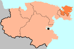
Map showing Chukotsky District; the black dot represents AnadyrCoordinates: 66°18′46″N 172°25′04″W / 66.31278°N 172.41778°WCoordinates: 66°18′46″N 172°25′04″W / 66.31278°N 172.41778°W Administrative status (as of 2009) Country Russia Federal subject Chukotka Autonomous Okrug[1] Administrative center selo of Lavrentiya[2] # of rural localities 6 Municipal status (as of November 2004) Municipally incorporated as Chukotsky Municipal District[3] - Head of Administration[4] Mikhail Zelensky[4] - # of rural settlements 6[3] Statistics Area 30,700 km2 (11,900 sq mi)[4] Population (2002 Census) 4,541 inhabitants[5] - Urban population 0% - Rural population 100% Population (2010 est.) 4,598 inhabitants[6] Density 0 /km2 (0 /sq mi)[7] Time zone MAGST (UTC+12:00)[8] Established 1927[4] Official website Chukotsky District (Russian: Чуко́тский райо́н) is an administrative and municipal district (raion), one of the six in Chukotka Autonomous Okrug, Russia.[1] It is the easternmost district of the autonomous okrug and the closest part of Russia to the United States. It borders with the Chukchi Sea in the north, the Bering Sea in the east, Providensky District in the south, and the Kolyuchinskaya Bay in the west. The area of the district is 30,700 square kilometers (11,900 sq mi).[4] Its administrative center is the rural locality (a selo) of Lavrentiya.[2] District's population: 4,598 (2010 est.);[6] 4,541 (2002 Census);[5] 6,878 (1989 Census).[9] Population of Lavrentiya accounts for 29.4% of the district's population.[5]
The district is populated mainly by indigenous peoples, the majority being either Chukchi or Yupik. The sparse nature of the population means that this is the only district in the autonomous okrug without any urban localities. The village of Uelen is located in the district, which is a focal point for indigenous artwork of the region as a whole and the birthplace of Yuri Rytkheu, the first internationally recognized Chukchi author.
Contents
Geography
Chukotsky District covers the northern half of the Chukchi Peninsula, at the northeastern tip of Eurasia. Prior to 1957, the area known as Chukotsky District was substantially larger, as this territory covered not only present-day Chukotsky District, but also present-day Providensky District, and a substantial area now included in Iultinsky District.
Uelen—the most easterly settlement in the Eurasian landmass famous for its whale bone carving—is located on the district's territory. It also features the most easterly point on the Eurasian landmass: Cape Dezhnev, named after Russian navigator Semyon Dezhnyov and formerly the setting for a Dalstroy gulag site, this cape was the starting point for Clemens Forell's epic journey in the novel As Far as My Feet Will Carry Me.[10]
The district also includes Big Diomede Island, sometimes called Tomorrow Island since it is 21 hours ahead of its partner Little Diomede despite being only 1 km away across the sea.
Demographics
Chukotsky District has the highest percentage of indigenous peoples in the whole of Chukotka, with 85% of people being of native origin.[11] The native peoples are primarily Chukchi,[12] but there are also small populations of Evens, Koryaks, and Yupik.[11]
The remaining 15% of the population is of non-indigenous origin;,[13] mainly Russian. These people either migrated to the Far East, or are the descendants of those who did, enticed by the higher pay, large pensions, and more generous allowances permitted to those prepared to endure the cold and the isolation, or, more likely, were exiled here as a result of one of Stalin's purges, or were exiled here having been released from the gulag.
History
For the indigenous peoples, life has been rather static for the last few millennia, judging from archaeological excavations. The region contains around 80 archaeological and historical sites, many of them in the vicinity of present-day villages.[11]
From the view of non-indigenous people, the area now known as Chukotsky District was a formidable place and was only gradually and tentatively explored in comparison with other areas of Chukotka. Semyon Dezhnyov and his Cossacks nearly had their entire fleet destroyed as they attempted to sail around the cape that would ultimately bear his name on their way to the Anadyr River in the mid-17th century. Eighty years later, Vitus Bering sailed through the strait which now bears his name, and five years later, the first maps of the coastline were drawn by the Second Kamchatka Expedition, but it was not for a further fifty-five years that the coast of the region was visited by James Cook and until the early 1900s before there was a permanent Russian presence in the form of trading posts in any of the villages.[11]
Prior to the establishment of the current administrative arrangement (with Chukotsky District as it is now being founded in 1927), Chukotsky Uyezd was founded with its center in Provideniya Bay in 1909, and in 1912, the administrative center was moved to Uelen with one of the first schools in the area opening there four years later.[11]
Economy
Unlike with many of the districts within Chukotka, Chukotsky District's economy is much more focused on traditional marine hunting and reindeer herding.[4] This is in part because, at around 85%, Chukotsky District has the highest percentage of indigenous peoples in the autonomous okrug. There is next to no industrial activity in this district, with the population mainly involved in reindeer herding, fishing, and seal hunting, with an administrative program in place to ensure that local indigenous peoples receive material incentives to continue with their traditional way of life.
Culture
 Dancers in Lorino
 Transport in Lorino
Although many native rural localities in the autonomous okrug have historical museums documenting the culture of the indigenous peoples, Chukotsky District has a particularly strong cultural tradition, with Uelen being a notable hub, particularly for whale bone carving. The village, famous for its walrus ivory carvings, and has long been a major artistic center in the region, with several of the leading exponents of the craft, such as Vukvutagin, Vukvol, Tukkay, and Khukhutan working out of Uelen, as well as being home to an indigenous choir which has a history of cultural collaboration with their Inuit cousins across the Bering Straight in Alaska.
The village also serves as the base for archaeological expeditions to the area, which have uncovered a burial ground containing more than 300 burials of Early Whale Hunter cultures, covering a time span from 500 BCE to 1000 CE. These excavations have shown that Uelen was a major settlement in the area in the first centuries CE. In addition to revealing the existence of a culture dependent on whale and walrus hunting, archeologists also unearthed early examples of the indigenous peoples ivory carvings, a number of which are now held at the Peter the Great Museum of Anthropology and Ethnography in St. Petersburg.[11]
The writer Yuri Rytkheu was born in Uelen in 1930 to a family of trappers and hunters and was the first Chukchi author to achieve national prominence. His book A Dream in Polar Fog deals with the Chukchi people's efforts to adapt when a foreigner is shipwrecked on their shores.[14]
The district hosts the dog sled race "Hope" and the sea hunters' "Beringiya" festival.
Divisions
Administrative divisions
Chukotsky Administrative District has administrative jurisdiction over six rural localities, listed below in the "Municipal divisions" section.
Municipal divisions
Chukotsky Municipal District is divided into six rural settlements.[3]
Municipal composition Rural settlements Rural localities in jurisdiction* Enurmino
(Энурмино)- selo of Enurmino
Inchoun
(Инчоун)- selo of Inchoun
Lavrentiya
(Лаврентия)- selo of Lavrentiya (administrative center of the district)
Lorino
(Лорино)- selo of Lorino
Neshkan
(Нешкан)- selo of Neshkan
Uelen
(Уэлен)- selo of Uelen
Source:[3]
*Administrative centers are shown in boldGallery
-

Ruined semi-subterranean house, Naukan, near Cape Dezhnev
-

Power generation, Lorino
-

Meat storage pit, Naukan. Whale ribs cover the pit.
-

Female dancers, Lorino
-

Abandoned Barrels near Lavrentiya
-

Family living in abandoned barrel
References
Notes
- ^ a b Law #33-OZ, Article 9.2
- ^ a b Law #33-OZ, Article 16.2
- ^ a b c d Law #47-OZ
- ^ a b c d e f Official website of Chukotka Autonomous Okrug. Chukotsky District
- ^ a b c Федеральная служба государственной статистики (Federal State Statistics Service) (2004-05-21). "Численность населения России, субъектов Российской Федерации в составе федеральных округов, районов, городских поселений, сельских населённых пунктов – районных центров и сельских населённых пунктов с населением 3 тысячи и более человек (Population of Russia, its federal districts, federal subjects, districts, urban localities, rural localities—administrative centers, and rural localities with population of over 3,000)" (in Russian). Всероссийская перепись населения 2002 года (All-Russia Population Census of 2002). Federal State Statistics Service. http://www.perepis2002.ru/ct/doc/1_TOM_01_04.xls. Retrieved 2010-03-23.
- ^ a b Федеральная служба государственной статистики (Federal State Statistics Service). Численность постоянного населения Российской Федерации по городам, посёлкам городского типа и районам на 1 января 2010 г. (Permanent Population of the Russian Federation by Cities/Towns, Urban-Type Settlements, and Districts as of January 1, 2010) (Russian)
- ^ The value of density was calculated automatically by dividing the 2002 Census population by the area specified in the infobox. Please note that this value may not be accurate as the area specified in the infobox does not necessarily correspond to the area of the entity proper or is reported for the same year as the population.
- ^ Правительство Российской Федерации. Постановление №725 от 31 августа 2011 г. «О составе территорий, образующих каждую часовую зону, и порядке исчисления времени в часовых зонах, а также о признании утратившими силу отдельных Постановлений Правительства Российской Федерации». Вступил в силу по истечении 7 дней после дня официального опубликования. Опубликован: "Российская Газета", №197, 6 сентября 2011 г. (Government of the Russian Federation. Resolution #725 of August 31, 2011 On the Composition of the Territories Included into Each Time Zone and on the Procedures of Timekeeping in the Time Zones, as Well as on Abrogation of Several Resolutions of the Government of the Russian Federation. Effective as of after 7 days following the day of the official publication).
- ^ "Всесоюзная перепись населения 1989 г. Численность наличного населения союзных и автономных республик, автономных областей и округов, краёв, областей, районов, городских поселений и сёл-райцентров. (All Union Population Census of 1989. Present population of union and autonomous republics, autonomous oblasts and okrugs, krais, oblasts, districts, urban settlements, and villages serving as district administrative centers.)" (in Russian). Всесоюзная перепись населения 1989 года (All-Union Population Census of 1989). Demoscope Weekly (website of the Institute of Demographics of the State University—Higher School of Economics. 1989. http://demoscope.ru/weekly/ssp/rus89_reg.php. Retrieved 2010-03-23.
- ^ Josef Martin Bauer. As Far as My Feet Will Carry Me
- ^ a b c d e f Fute, p. 111ff
- ^ Norwegian Polar Institute. Indigenous Peoples of the north of the Russian Federation, Map 3.6
- ^ Fute, p. 85ff
- ^ Yury Rytkheu. A Dream in Polar Fog, trans. by Ilona Yazhbin Chavasse. Archipelago Books, 2006. ISBN 978-0977857616
Sources
- Дума Чукотского автономного округа. Закон №33-ОЗ от 30 июня 1998 г. «Об административно-территориальном устройстве Чукотского автономного округа», в ред. Закона №73-ОЗ от 24 июня 2009 г. «О внесении изменений в Закон Чукотского автономного округа "Об административно-территориальном устройстве Чукотского автономного округа"». Вступил в силу по истечении десяти дней со дня его официального опубликования. Опубликован: "Ведомости", №7 (28), 14 мая 1999 г. (Duma of Chukotka Autonomous Okrug. Law #33-OZ of June 30, 1998 On the Administrative and Territorial Structure of Chukotka Autonomous Okrug, as amended by the Law #73-OZ of June 24, 2009 On Amending the Law of Chukotka Autonomous Okrug "On the Administrative and Territorial Structure of Chukotka Autonomous Okrug". Effective as of after ten days from the day of the official publication).
- Дума Чукотского автономного округа. Закон №47-ОЗ от 29 ноября 2004 г. «О статусе, границах и административных центрах муниципальных образований на территории Чукотского района Чукотского автономного округа». Вступил в силу через десять дней со дня официального опубликования. Опубликован: "Ведомости", №31/1 (178/1), 10 декабря 2004 г. (Duma of Chukotka Autonomous Okrug. Law #47-OZ of November 29, 2004 On the Status, Borders, and Administrative Centers of the Municipal Formations on the Territory of Chukotsky District of Chukotka Autonomous Okrug. Effective as of the day which is ten days after the official publication date).
Administrative divisions of Chukotka Autonomous Okrug Administrative center: AnadyrCities and towns 
Urban-type settlements Aliskerovo · Baranikha · Beringovsky · Bystry · Dalny · Egvekinot · Komsomolsky · Krasnoarmeysky · Leningradsky · Mys Shmidta · Otrozhny · Provideniya · Shakhtyorsky · Ugolnye Kopi · Valkumey · Vesenny · Vstrechny · YuzhnyAdministrative districts (raions) Categories:- Districts of Chukotka Autonomous Okrug


Wikimedia Foundation. 2010.