- St John's Church, Dukinfield
-
St John's Church, Dukinfield 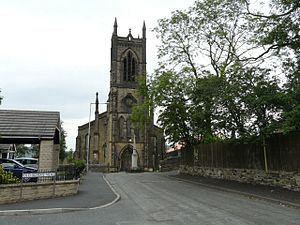
St John's Church, Dukinfield, from the westLocation in Greater Manchester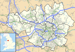
 St John's Church, Dukinfield
Coordinates: 53°28′38″N 2°04′21″W / 53.4771°N 2.0726°W OS grid reference SJ 952 978 Location Dukinfield, Greater Manchester Country England Denomination Anglican Website St John's, Dukinfield History Founded 3 September 1838 Dedication St John the Evangelist Consecrated 24 May 1841 Architecture Status Parish church Functional status Active Heritage designation Grade II Designated 6 February 1986 Architect(s) Edmund Sharpe Architectural type Church Style Gothic Revival Groundbreaking 1838 Completed 1840 Construction cost £3,299
(£230,000 as of 2011)[1]Specifications Materials Stone, slate roof Administration Parish St John the Evangelist, Dukindield Deanery Mottram Archdeaconry Macclesfield Diocese Chester Province York Clergy Vicar(s) Revd Tim Hayes St John's Church, Dukinfield, stands in Oxford Road, Dukinfield, Greater Manchester, England. It is an active Anglican parish church in the deanery of Mottram, the archdeaconry of Macclesfield and the diocese of Chester.[2] The church has been designated by English Heritage as a Grade II listed building.[3] It stands in an elevated position at the top of a small hill.[4]
Contents
History
St John's is a Commissioners' church designed by the Lancaster architect Edmund Sharpe, and built in 1838–40.[5] The church cost £3,299 (£230,000 as of 2011)[1] to build and £2,599 of this was met by a grant from the Church Building Commission.[6] The foundation stone was laid on 3 September 1838, the same day as that at St George's Church, Stalybridge, also designed by Sharpe. It was consecrated on 24 May 1841 by Rt Revd John Bird Sumner, who was at that time the Bishop of Chester. The church opened for worship in July. Fifty years later the church was restored, with little alteration other than the addition of two windows to the chancel.[4]
Architecture
The church is built in stone with a slate roof. Its plan consists of a five-bay nave with north and south aisles, a short single-bay chancel, and a tower at the west end. The tower is in four stages, it has a west door, and at the top is a coped parapet and pinnacles. A coped parapet also runs along the walls and gables of the church. The windows are paired lancets. Inside the church are galleries on three sides. The galleries and the nave arcades are supported by octagonal columns. The organ is in the west gallery.[3][5]
See also
- List of architectural works by Edmund Sharpe
- List of Commissioners' churches in Northeast and Northwest England
References
- ^ a b UK CPI inflation numbers based on data available from Lawrence H. Officer (2010) "What Were the UK Earnings and Prices Then?" MeasuringWorth.
- ^ Dukinfield, St John the Evangelist, Church of England, http://www.achurchnearyou.com/dukinfield-st-john-the-evangelist/, retrieved 26 March 2010
- ^ a b "Church of St John the Evangelist, Trafford", The National Heritage List for England (English Heritage), 2011, http://list.english-heritage.org.uk/resultsingle.aspx?uid=1068017, retrieved 14 May 2011
- ^ a b Hughes, John M. (2010), Edmund Sharpe: Man of Lancaster, John M. Hughes, p. 163
- ^ a b Hartwell, Claire; Hyde, Matthew; Hubbard, Edward; Pevsner, Nikolaus (2011) [1971], Cheshire, The Buildings of England, New Haven and London: Yale University Press, pp. 336–337, ISBN 978-0-300-17043-6
- ^ Port, M. H. (2006), 600 New Churches: The Church Building Commission 1818-1856 (2nd ed.), Reading: Spire Books, p. 331, ISBN 978-1-904965-08-4
Categories:- Church of England churches in Greater Manchester
- Grade II listed churches
- Grade II listed buildings in Greater Manchester
- Gothic Revival architecture in England
- Religious buildings completed in 1840
- 18th-century Church of England church buildings
- 19th-century church buildings
- Anglican congregations established in the 19th century
- Diocese of Chester
- Edmund Sharpe buildings
- Commissioners' churches


Wikimedia Foundation. 2010.