- Clanville
-
Coordinates: 51°14′17″N 1°32′39″W / 51.238092°N 1.5441940°W
Clanville 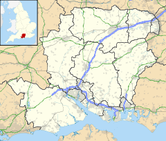
 Clanville
Clanville shown within HampshireOS grid reference SU3191748867 Parish Clanville District Test Valley Shire county Hampshire Region South East Country England Sovereign state United Kingdom Post town ANDOVER Postcode district SP11 Dialling code 01264 Police Hampshire Fire Hampshire Ambulance South Central EU Parliament South East England UK Parliament North West Hampshire List of places: UK • England • Hampshire Clanville is a small village and civil parish in the Test Valley district of Hampshire, England. The village is situated in the North Downs Area Of Outstanding Natural Beauty on the Hampshire-Wiltshire border. Its nearest town is Andover, which lies approximately 5.6 miles (9.1 km) south-east from the village.
Towns, villages and hamlets in the Test Valley District of Hampshire, England 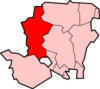 Abbotswood · Abbotts Ann · Abbotts Ann Down · Ampfield · Amport · Andover · Andover Down · Anna Valley · Appleshaw · Ashfield · Awbridge · Barton Stacey · Bossington · Braishfield · Broughton · Charlton · Chattis Hill · Chilbolton · Chilbolton Down · Clanville · Crampmoor · Dunbridge · Dunley · East Anton · Embley · East Cholderton · East Dean · East Tytherley · Faberstown · Faccombe · Finkley · Finkley Down · Forton · Fox Amport · Foxcotte · Freefolk · Fullerton · Fyfield · Goodworth Clatford · Gore End · Grateley · Hatherden · Hillyfields · Houghton · Houghton Down · Hurstbourne Tarrant · Kimbridge · Kimpton · King's Somborne · Knights Enham · Leckford · Lickenholt · Little Down · Little Hatherden · Little Somborne · Lockerley · Longparish · Longstock · Longstock Park · Lower Wyke · Marsh Court · Michelmersh · Middle Wallop · Monxton · Mottisfont · Nether Wallop · Newton Stacey · North Baddesley · North Houghton · Nursling · Over Wallop · Penton Corner · Penton Grafton · Picket Piece · Picket Twenty · Pill Heath · Plaitford · Quarley · Ragged Appleshaw · Ramridge Park · Red Post Bridge · Red Rice · Redenham · Romsey · Sherfield English · Shipton Bellinger · Shootash · Smannell · South Harewood · Stockbridge · Tangley · Thruxton · Up Somborne · Upper Clatford · Upper Enham · Vernhams Dean · Vernham Street · Wellow · West Tytherley · Wherwell · Wherwell Wood · WildhernCategories:
- Hampshire geography stubs
- Villages in Hampshire
- Test Valley


Wikimedia Foundation. 2010.