- Upper Falls (District Electoral Area)
-
Upper Falls
District Electoral Area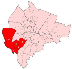
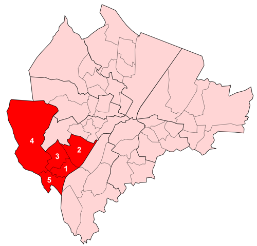
Map showing Upper Falls wards within BelfastPopulation (2008 Estimate) District Belfast City Council County County Antrim Country Northern Ireland Sovereign state United Kingdom EU Parliament Northern Ireland UK Parliament Belfast West NI Assembly Belfast West List of places: UK • Northern Ireland • Antrim Upper Falls is one of the nine district electoral areas (DEA) in Belfast, Northern Ireland. Located in the west of the city, the district elects five members to Belfast City Council and contains the wards of Andersonstown; Falls Park; Glen Road; Glencolin; and Ladybrook. Upper Falls forms part of the Belfast West constituencies for the Northern Ireland Assembly and UK Parliament. The district, along with the neighbouring Lower Falls district, takes its name from the Falls Road, one of the main arterial routes in the west of the city.
Contents
History
The district was created for the 1985 local elections. All five wards were part of Area D before 1985. Area D had also contained three wards which became part of the Lower Falls electoral area.
Wards
Map Ward Population
(2008 Estimate)Population
(2001 Census)Catholic Protestant Other Area Density NI Assembly UK Parliament Ref 1 Andersonstown 5,238 5,764 98.5% 1.0% 0.5% 1.08 km2 5,337/km2 Belfast West Belfast West [1] 2 Falls Park 5,234 5,888 97.7% 1.8% 0.5% 2.35 km2 2,506/km2 Belfast West Belfast West [2] 3 Glen Road 5,406 5,872 97.2% 2.3% 0.5% 1.57 km2 3,740/km2 Belfast West Belfast West [3] 4 Glencolin 6,892 7,129 98.1% 1.2% 0.7% 9.54 km2 747/km2 Belfast West Belfast West [4] 5 Ladybrook 6,312 6,384 86.5% 12.3% 1.2% 1.29 km2 4,949/km2 Belfast West Belfast West [5] Upper Falls 29,082 31,039 95.5% 3.8% 0.7% 15.83 km2 1,961/km2 Belfast West Belfast West Councillors
Election Councillor
(Party)Councillor
(Party)Councillor
(Party)Councillor
(Party)Councillor
(Party)2011 Gerard O'Neill
(Sinn Féin)Tim Attwood
(SDLP)Caoimhin Mac Giolla Mhín
(Sinn Féin)Emma Groves
(Sinn Féin)Matt Garrett
(Sinn Féin)2005 Christine Mhic Giolla Mhín
(Sinn Féin)Michael Browne
(Sinn Féin)Paul Maskey
(Sinn Féin)2001 Alex Attwood
(SDLP)Chrissie McAuley
(Sinn Féin)1997 Martin Livingstone
(Sinn Féin)Alex Maskey
(Sinn Féin)1993 Mairtin O Muilleoir
(Sinn Féin)Patricia Lewsley
(SDLP)Una Gillsepie
(Sinn Féin)1989 Cormac Boomer
(SDLP)T M Holland
(Sinn Féin)1985 Pip Glendinning
(Alliance)2011 Elections
Belfast City Council elections, 2011[6] Party Candidate 1st Pref Sinn Féin Matt Garrett 2,250 Sinn Féin Gerard O'Neill 2,184 Sinn Féin Emma Groves 2,133 SDLP Tim Attwood 2,015 Sinn Féin Caoimhin Mac Giolla Mhín 1,910 Éirígí Pádraic Mac Coitir 1,415 SDLP Helen Walsh 250 Democratic Unionist Eileen Kingston 179 Alliance Dan McGuinness 162 Turnout 12,498 No change See also
- Belfast City Council
- Electoral wards of Belfast
- Local government in Northern Ireland
- Members of Belfast City Council
References
- ^ "Ward Information for Andersonstown ward 95GG01". NISRA. http://www.ninis.nisra.gov.uk/mapxtreme/pf_report.asp?sLevel=WARD&sID=95GG01&sName=Andersonstown. Retrieved 13 June 2011.
- ^ "Ward Information for Falls Park ward 95GG22". NISRA. http://www.ninis.nisra.gov.uk/mapxtreme/pf_report.asp?sLevel=WARD&sID=95GG22&sName=Falls%20Park. Retrieved 13 June 2011.
- ^ "Ward Information for Glen Road ward 95GG25". NISRA. http://www.ninis.nisra.gov.uk/mapxtreme/pf_report.asp?sLevel=WARD&sID=95GG25&sName=Glen%20Road. Retrieved 13 June 2011.
- ^ "Ward Information for Glencolin ward 95GG27". NISRA. http://www.ninis.nisra.gov.uk/mapxtreme/pf_report.asp?sLevel=WARD&sID=95GG27&sName=Glencolin. Retrieved 13 June 2011.
- ^ "Ward Information for Ladybrook ward 95GG31". NISRA. http://www.ninis.nisra.gov.uk/mapxtreme/pf_report.asp?sLevel=WARD&sID=95GG31&sName=Ladybrook. Retrieved 13 June 2011.
- ^ Elections 2011: Upper Falls, Belfast City Council

'Lisburn City Council Court
Lower FallsBalmoral
Lower Falls'Lisburn City Council 
Balmoral  Upper Falls

Lisburn City Council Balmoral Balmoral Belfast City Council General 
People District Electoral Areas Amenities Parks and gardens Cemeteries Balmoral Cemetery • Belfast City Cemetery • Clifton Street Cemetery • Roselawn CemeteryElections See also: Local government in Northern Ireland • CategoryCategories:- Electoral wards of Belfast

Wikimedia Foundation. 2010.