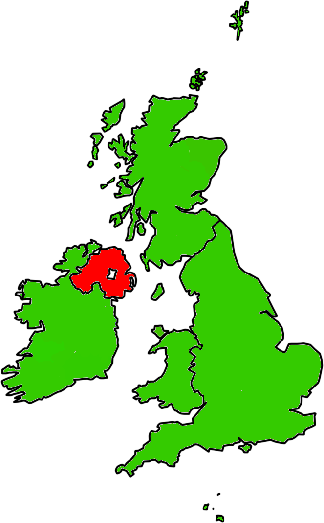
- Counties of Northern Ireland
-
 Counties of Northern Ireland
The counties of Northern Ireland were the principal local government divisions of Northern Ireland from its creation in 1921 until 1972 when their governmental features were abolished and replaced with twenty-six unitary authorities.[1]
Northern Ireland consists of six counties: Antrim, Armagh, Down, Fermanagh, Londonderry, and Tyrone. These form two-thirds of the historical province of Ulster.
According to certain sources, the six-pointed star of the former Government of Northern Ireland flag represents the six counties that make up Northern Ireland.[citation needed]
Contents
The counties
County County town First created[2] Est. population (2006)[citation needed] Extra County Antrim Antrim Early 14th century 566,000 Modern boundaries formed in 1605.[2] County Armagh Armagh 1584 141,000 County Down Downpatrick Early 14th century 492,840 Modern boundaries formed in 1605.[2] County Fermanagh Enniskillen 1584 55,000 Based on the territory of the Maguires. County Londonderry Coleraine 1613 233,500 Merging of County Coleraine (also spelt as Colerain[3][4]), and the baronies of Loughinsholin, North East Liberties of Coleraine, and the North West Liberties of Londonderry County Tyrone Omagh 1584 166,516 Based on the Irish kingdom of Tír Eoghain, with its north-eastern part (barony of Loughinsholin) being merged with County Londonderry in 1613. Background of the counties
The English administration in Ireland in the years following the Anglo-Norman invasion of Ireland, created counties as the major subdivisions of an Irish province.[2] This process lasted a period from the 13th to 17th centuries, however the number and shape of the counties that would form the future Northern Ireland would not be defined until the Flight of the Earls allowed the shiring of Ulster from 1604.[1]
Though the present-day counties of Northern Ireland were planned in the early 16th century, some had already existed in one form or another beforehand although their boundaries would be adjusted.[2] Each county would have an associated county town, with county courts of Quarter Sessions and Assizes.[2]
Origins
The counties of Antrim and Down have their origins in the Norman Earldom of Ulster which was based on John de Courcy's conquest of Ulaid.[5] Between the late 13th and early 14th centuries it was organised into administrative shires based around centres of Norman power such as Antrim, Carrickfergus, and Newtownards.[5]
The Bruce invasion (1315–18) saw the devastation of the Earldom of Ulster and its overlordship over the neighbouring Gaelic districts. With the murder of the last de Burgh earl in 1333, the resulting Gaelic recovery eroded the earldoms territory until by the 15th century only the areas of Carrickfergus and coastal enclaves in Down remained.[5]
It wasn't until the reign of Queen Elizabeth I that Ulster would be shired into more counties; based largely on the boundaries of existing lordships. In 1584, Lord Deputy of Ireland Sir John Perrott created the following counties in what is now Northern Ireland: Armagh; Coleraine; Fermanagh; and Tyrone. Carrickfergus would retain its status as a county town until 1777 when it was merged with County Antrim.
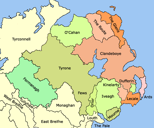
Development of Northern Ireland's counties 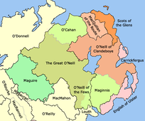 Later 15th century - Boundaries of counties and lordships (black border) and minor lordships (grey border) in Ulster.
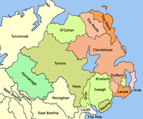 Early 16th century - General boundaries of lordships in Ulster.
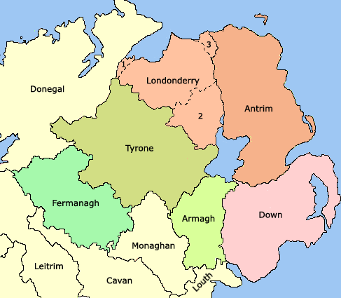
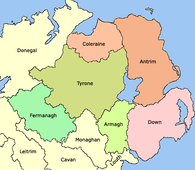 1584 - General boundaries of the counties of Ulster created by the Lord Deputy of Ireland Sir John Perrott.
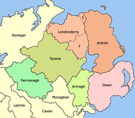 1613 - Ulster after the creation of County Londonderry, from the merger of County Coleraine, the North West Liberties of Londonderry (1), Loughinsholin (2), and North East Liberties of Coleraine (3).
Baronies
Each county was divided into a number of baronies, a mid-way between a county and a parish. Baronies are now obsolete administrative units, partially derived from the territory of an Irish chieftain. By the time the process of turning local Irish kingdoms into baronies occurred throughout the whole of Ulster by the early 17th century as part of the Plantation of Ulster, it was already being used for taxation and administrative purposes.[2]
Baronies were used for many records from the 17th to 19th centuries such as: the Civil Survey; Petty's Down Survey; the Books of Survey and Distribution; the 19th century valuation books and census returns. The Grand Jury representment system would also be based on the barony.[2]
Government and Modern Usage
Main article: Districts of Northern IrelandThe counties were also used as the administrative unit of local government introduced in Ireland under the 1898 Local Government Act, and in the case of what would become Northern Ireland, two county boroughs; Belfast and Londonderry. These were abolished in Northern Ireland in 1972 which saw the creation of twenty-six unitary councils, many of which cross county boundaries.
The six administrative counties and two county boroughs remain in use for some purposes, including car number plates. They were also used as postal counties by the Royal Mail for sorting purposes until their abolition in 1996.
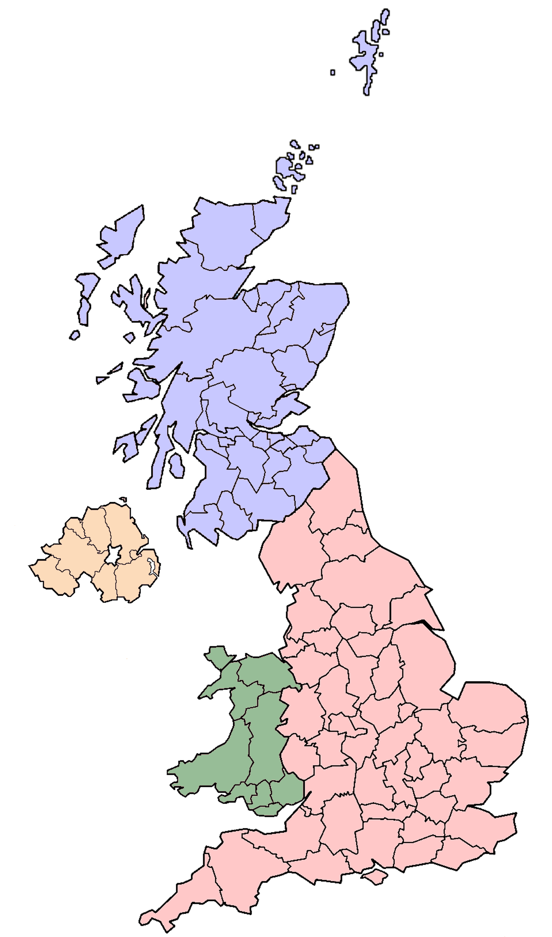
 The lieutenancy areas of the UK, with NI shaded orange
Lieutenancy areas
Like the rest of the United Kingdom, Northern Ireland is divided into lieutenancy areas (see map on right). These are districts that have an appointed Lord Lieutenant—the representative of the British monarch. Northern Ireland has eight lieutenancy areas: Antrim, Armagh, Down, Fermanagh, Tyrone, County of Londonderry, City of Londonderry, and City of Belfast.
Former counties
Former counties which formed part of the six modern counties of Northern Ireland:
- County Coleraine formed from the territory of the O'Cahans in 1584 by Queen Elizabeth I, formed the basis of modern County Londonderry.
- Tyrone was formerly divided into Nether Tyrone and Upper Tyrone.
- Carrickfergus was formerly a county of itself, it extended further than the modern borough of Carrickfergus. It was merged into County Antrim in 1777.
- Twescard, Blathewyc (Newtownards), del Art (Ards), Ladcathel (Lecale), four of seven counties that formed the Earldom of Ulster in 1333.[6]
References
- ^ a b Connolly, J.S.: Oxford Companion to Irish History, page 129. Oxford University Press, 2002. ISBN 978-0-19-923483-7
- ^ a b c d e f g h Public Records Office of Northern Ireland - Areas, regions, and land divisions
- ^ LibraryIreland - Principal Families of Ulster: In Tirowen, section (c) The modern nobility in Tir Owen
- ^ Google Books - The Fall of Irish Chiefs and Clans; The Conquest of Ireland, by George Hill
- ^ a b c Connolly, J.S.: Oxford Companion to Irish History, page 589-590. Oxford University Press, 2002. ISBN 978-0-19-923483-7
- ^ Bardon, Jonathan, A History of Ulster, page 45. The Black Syaff Press, 2005. ISBN 0-85640-764-X
See also
- Counties of the United Kingdom
- Counties of Ireland
- List of Irish counties by population
- List of Irish counties by area
- Provinces of Ireland
Categories:


Wikimedia Foundation. 2010.