List of parliamentary constituencies in Northern Ireland

List of parliamentary constituencies in Northern Ireland

Northern Ireland is divided into 18 Parliamentary constituencies - 4 borough constituencies in Belfast and 14 county constituencies elsewhere. Each area returns one Member of Parliament (MP) to the House of Commons at Westminster and six Members of the Legislative Assembly (MLAs) to the devolved Northern Ireland Assembly at Stormont. Parliamentary constituencies are not used for local government, which is instead carried out by 26 district councils; these often have different boundaries.

Name Current boundaries Name
  1. Belfast East
  2. Belfast North
  3. Belfast South
  4. Belfast West
  5. East Antrim
  6. East Londonderry
  7. Fermanagh & South Tyrone
  8. Foyle
  9. Lagan Valley
Parliamentary constituencies in Northern Ireland
  1. Mid Ulster
  2. Newry & Armagh
  3. North Antrim
  4. North Down
  5. South Antrim
  6. South Down
  7. Strangford
  8. Upper Bann
  9. West Tyrone

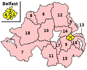
2010 General Election

      Democratic Unionist       Sinn Féin       Social Democratic and Labour       Ulster Unionist       Alliance Party       Conservative       Traditional Unionist Voice       Independent
The data in this table is from the BBC Election Website.

Name[nb 1] Electorate Majority[nb 2] Member of Parliament Nearest opposition Map
Belfast East BC 60,129 1,533 Naomi Long Peter Robinson
A very small constituency, located in the east of the country.
Belfast North BC 63,193 2,224 Nigel Dodds Gerry Kelly
A very small constituency, located in the east of the country
Belfast South BC 58,225 5,926 Alasdair McDonnell Jimmy Spratt
A very small constituency, located in the East of the country.
Belfast West BC* 60,817 13,123 Paul Maskey Alex Attwood
A very small constituency, located in the East of the country.
East Antrim CC 56,125 6,770 Sammy Wilson Rodney McCune
A medium-sized constituency, located in the East of the country.
East Londonderry CC 60,494 5,355 Gregory Campbell Cathal Ó hOisín
A fairly large constituency, located in the north of the country.
Fermanagh & South Tyrone CC 64,345 4 Michelle Gildernew Rodney Connor
A very large constituency, comprising the southwest area of the country.
Foyle CC 60,823 4,824 Mark Durkan Martina Anderson
A medium-sized constituency found in the south east of the county.
Lagan Valley CC 60,973 10,486 Jeffrey Donaldson Daphne Trimble
A medium constituency located inland, in the southeast of the country.
Mid Ulster CC 60,119 15,363 Martin McGuinness Ian McCrea
A medium constituency, located slightly to the north and west of the centre of the country.
Newry & Armagh CC 68,730 8,331 Conor Murphy Dominic Bradley
A medium constituency in the south of the country.
North Antrim CC 72,814 12,558 Ian Paisley, Jr. Jim Allister
A large constituency in the north of the county.
North Down CC 57,435 14,364 Sylvia Hermon Ian Parsley
A medium-sized constituency found in the south east of the county.
South Antrim CC 56,594 1,183 William McCrea Reg Empey
A medium constituency located in the extreme south west of the county.
South Down CC 64,530 8,412 Margaret Ritchie Catriona Ruane
A medium constituency located in the centre of the county. Due to the elongated shape of the county, no constituencies border it to the north or the south despite its central location.
Strangford CC 57,463 5,876 Jim Shannon Mike Nesbitt
A small constituency. It is situated in the south west of the county, although it borders another constituency located further south west.
Upper Bann CC 68,806 3,361 David Simpson Harry Hamilton
A large constituency in the north of the county.
West Tyrone CC 57,847 10,685 Pat Doherty Thomas Buchanan
A medium-sized constituency found in the south east of the county.
  • Result of Belfast West by-election, 2011
Constituency Unionist vote Republican/Nationalist vote Neutral/Other vote
North Down 88.6 2.7 8.7
Strangford 79.3 10.3 10.4
Lagan Valley 79.5 9.0 11.4
North Antrim 74.1 21.2 4.6
South Antrim 69.7 22.6 7.7
East Antrim 75.6 13.4 11.1
Upper Bann 59.5 37.5 3.0
East Londonderry 59.8 34.7 5.5
Belfast North 47.7 46.3 6.0
Belfast East 59.4 3.5 37.2
Belfast West 10.7 87.5 1.9
Belfast South 41.0 41.0 18.0
Foyle 15.0 76.6 8.3
South Down 19.4 77.2 3.4
Fermanagh & South Tyrone 45.5 53.1 1.8
Mid Ulster 32.7 66.3 1.0
West Tyrone 34.0 62.4 3.7
Newry & Armagh 31.9 65.4 2.7

Notes

  1. ^ BC denotes borough constituency, CC denotes county constituency.
  2. ^ The majority is the number of votes the winning candidate receives more than their nearest rival.

References


Wikimedia Foundation. 2010.

Игры ⚽ Поможем решить контрольную работу

Look at other dictionaries:

  • List of Parliamentary constituencies in Clwyd — There are eight constituencies covering Clwyd. They are all county constituencies (CCs) of the House of Commons of the Parliament of the United Kingdom (Westminster), and are used also, since the 1999 Welsh Assembly election, for elections to the …   Wikipedia

  • List of Parliamentary constituencies in Mid Glamorgan — The Parliamentary constituency boundaries used in Wales up to the United Kingdom general election, 2005 were drawn up before the local government reorganisation in 1996, and subsequent changes to Preserved counties boundaries have left some… …   Wikipedia

  • List of Parliamentary constituencies in Dyfed — There are five constitencies covering Dyfed. They are all county constituencies (CCs) of the House of Commons of the Parliament of the United Kingdom (Westminster), and are used also, since the 1999 Welsh Assembly election, for elections to the… …   Wikipedia

  • List of political parties in Northern Ireland — Northern Ireland This article is part of the series: Politics and government of Northern Ireland …   Wikipedia

  • Parliamentary constituencies in Hertfordshire — The county of Hertfordshire in relation to England The county of Hertfordshire in England is divided into eleven Parliamentary constituencies. Each of the eleven elects a Member of Parliament (MP) to represent it at the United K …   Wikipedia

  • Northern Ireland Forum — 1982 ← members 30 May 1996 → 1998 members …   Wikipedia

  • Northern Ireland — This article is about the country. For other uses, see Northern Ireland (disambiguation). Northern Ireland Tuaisceart Éireann Norlin Airlann …   Wikipedia

  • Northern Ireland flags issue — The Northern Ireland flags issue is one that divides the population along sectarian lines. Depending on political allegiance, people identify with differing flags and symbols, some of which have, or have had, official status in Northern Ireland.… …   Wikipedia

  • List of UK Parliament Constituencies in Ireland and Northern Ireland — Ireland became part of the United Kingdom under the Act of Union 1800 from 1 January 1801.The electoral effect of the Act of Union 1800Under the Act of Union 1800, Ireland was divided into constituencies for elections to the United Kingdom… …   Wikipedia

  • Official names of United Kingdom Parliamentary constituencies in England — This article lists constituencies in England. For the main notes and the lists for other parts of the United Kingdom see Official names of United Kingdom Parliamentary constituencies. This article lists constituency names A M. For constituency… …   Wikipedia

Share the article and excerpts

Direct link
Do a right-click on the link above
and select “Copy Link”