- Zemplén County
-
This article is about the historical county of the Kingdom of Hungary; for other uses, see Zemplín.
Zemplén County County of the Kingdom of Hungary 12th century–1920 
Coat of arms
Capital Sátoraljaújhely History - Established 12th century - Treaty of Trianon June 4 1920 Area - 1910 6,282 km2 (2,425 sq mi) Population - 1910 343,200 Density 54.6 /km2 (141.5 /sq mi) Today part of Slovakia, Hungary Zemplén (Hungarian: Zemplén, Slovak: Zemplín, German: Semplin, Latin: Zemplinum) is the name of a historic administrative county (comitatus) of the Kingdom of Hungary. Its territory is presently situated in eastern Slovakia under the name of Zemplín. Most of the county's territory is today in Slovakia except the southern portions of the county, that are in Hungary, in Borsod-Abaúj-Zemplén County.
Contents
Geography
 Zemplén county
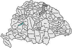
Zemplén county shared borders with Poland (during some periods the Austrian crownland Galicia) and the Hungarian counties Sáros (Šariš), Abaúj-Torna (Abov-Turňa), Borsod, Szabolcs and Ung (Uh). It was situated in the easternmost strip of what is now Slovakia (except for the region between Vihorlatské vrchy and the Latorica river), plus a strip along the Bodrog and Tisza rivers in present-day Hungary. The rivers Laborec and Bodrog flowed through the county. Its area was 6,269 km² around 1910.
Capitals
Initially, the capital of the county was the Zemplín Castle, in the 13th century also Sárospatak (in Slovak: Potok, hence the alternative name of the county comitatus de Potok). Since the Late Middle Ages the capital was the town of Zemplén, and since 1748 was Sátoraljaújhely (Slovak: Nové Mesto pod Šiatrom).
History
Zemplén was one of the oldest counties of the Kingdom of Hungary. In the aftermath of World War I, the northern part of Zemplén county became part of newly formed Czechoslovakia, as recognized by the concerned states in the 1920 Treaty of Trianon. The southern half (including the bigger part of the divided Sátoraljaújhely) stayed in Hungary as the county Zemplén. Following the provisions of the controversial First Vienna Award, an additional part came under Hungarian control in November 1938. The Trianon borders were restored after World War II.
Religions (1910 census):
- Roman Catholic 38.6%
- Greek Catholic 30.0%
- Calvinist 19.7%
- Jewish 9.6%
- Lutheran 2.0%
- Greek Orthodox 0.1%
Subdivisions
In the early 20th century, the subdivisions of Zemplén/Zemplín county were:
Districts (járás) District Capital Bodrogköz, SK Medzibodrožie Királyhelmec, SK Královský Chlmec Gálszécs Gálszécs, SK Sečovce Homonna Homonna, SK Humenné Mezőlaborc Mezőlaborc, SK Medzilaborce Nagymihály Nagymihály, SK Michalovce Sárospatak Sárospatak Sátoraljaújhely Sátoraljaújhely Szerencs Szerencs Szinna Szinna, SK Snina Sztropkó Sztropkó, SK Stropkov Tokaj Tokaj Varannó Varannó, SK Vranov nad Topľou Urban districts (rendezett tanácsú város) Sátoraljaújhely The towns of Sátoraljaújhely, Sárospatak, Tokaj and Szerencs are presently in Hungary.
See also: Zemplín (region)Counties of the Kingdom of Hungary (1886) Abaúj-Torna · Alsó-Fehér · Arad · Árva · Bács-Bodrog · Baranya · Bars · Békés · Bereg · Beszterce-Naszód · Bihar · Borsod · Brassó · Csanád · Csík · Csongrád · Esztergom · Fejér · Fogaras · Gömör-Kishont · Győr · Hajdú · Háromszék · Heves · Hont · Hunyad · Jász-Nagykun-Szolnok · Kis-Küküllő · Kolozs · Komárom · Krassó-Szörény · Liptó · Máramaros · Maros-Torda · Moson · Nagy-Küküllő · Nógrád · Nyitra · Pest-Pilis-Solt-Kiskun · Pozsony · Sáros · Somogy · Sopron · Szabolcs · Szatmár · Szeben · Szepes · Szilágy · Szolnok-Doboka · Temes · Tolna · Torda-Aranyos · Torontál · Trencsén · Turóc · Udvarhely · Ugocsa · Ung · Vas · Veszprém · Zala · Zemplén · Zólyom
Corpus separatum: Fiume
Autonomous Kingdom of Croatia-Slavonia: Bjelovar-Križevci · Lika-Krbava · Modruš-Rijeka · Požega · Srijem · Varaždin · Virovitica · Zagreb
 Categories:
- 1920 disestablishments
- Counties in the Kingdom of Hungary
- States and territories established in the 12th century


Wikimedia Foundation. 2010.