- Davis Mountains State Park
-
Davis Mountains State Park 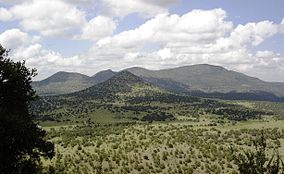
Davis Mountains
Location Jeff Davis County, Texas Nearest city Fort Davis Coordinates 30°35′45″N 103°55′58″W / 30.59583°N 103.93278°WCoordinates: 30°35′45″N 103°55′58″W / 30.59583°N 103.93278°W Area 2,709 acres (1,096 ha) Established 1938-1939 Governing body Texas Parks and Wildlife Department 
Davis Mountains State Park is a 2,709-acre (1,096 ha) state park located in the Davis Mountains in Jeff Davis County, Texas. The closest town is Fort Davis, Texas. The park elevation is between 5000 and 6000 feet above sea level. The original portion of the park was deeded to Texas Parks and Wildlife Department by a local family. Original improvements were accomplished by the Civilian Conservation Corps in 1933 and the park was opened to the public around 1938. Campground facilities were added in 1967.
Contents
Features
The park is next to the Fort Davis National Historic Site and the two are connected by four miles of hiking trails. Within the park is the "Indian Lodge", an adobe motel with 39 rooms that was built by the Civilian Conservation Corps in the 1930s.
The park has seven miles of equestrian trails in the special use Limpia Canyon Primitive Area, the section of the park north of Texas State Highway 118.
Flora
Fort Davis State Park receives more rain than the surrounding desert and hosts a variety of trees such as pinyon pines, Ponderosa Pine (Pinus ponderosa), Emory Oak (Quercus emoryi), Gray Oak (Quercus grisea) and One-seed Juniper (Juniperus monosperma). Shrubs such as Scarlet Bouvardia (Bouvardia ternifolia), Little-leaf Leadtree (Leucaena retusa), Trompillo (Ipomoea hederifolia), Evergreen Sumac (Rhus virens), Fragrant Sumac (Rhus aromatica), Apache Plum (Fallugia paradoxa), Little Walnut (Juglans microcarpa), Tree Cholla (Cylindropuntia imbricata), Torrey Yucca (Yucca torreyi), Catclaw Acacia (Acacia greggii), and Agarita (Mahonia trifoliolata) abound.
Fauna
Montezuma Quail are regularly observed in the park. Western Scrub Jays, White-winged Doves, Curve-billed Thrashers, and Rock Squirrels are among the most common wildlife seen. Collared Peccary, Cougars and bears have also been recorded in the park.
See also
References
External links
Protected Areas of Texas Federal El Orcoquisac Archeological District · Fort Davis National Historic Site · Lyndon B. Johnson National Historical Park · Palo Alto Battlefield National Historical Park · San Antonio Missions National Historical ParkAnahuac · Aransas · Attwater Prairie Chicken · Balcones Canyonlands · Big Boggy · Brazoria · Buffalo Lake · Grulla · Hagerman · Laguna Atascosa · Lower Rio Grande Valley · McFaddin · Muleshoe · San Bernard · Santa Ana · Texas Point · Trinity RiverState Abilene · Atlanta · Balmorhea · Barton Warnock Environmental Education Center · Bastrop · Bentsen-Rio Grande Valley · Big Bend Ranch · Big Spring · Blanco · Boca Chica · Bonham · Brazos Bend · Buescher · Caddo Lake · Caprock Canyons · Cedar Hill · Choke Canyon · Cleburne · Colorado Bend · Cooper Lake · Copper Breaks · Daingerfield · Davis Mountains · Devils River State Natural Area · Devil's Sinkhole State Natural Area · Dinosaur Valley · Eisenhower · Enchanted Rock State Natural Area · Estero Llano Grande · Fairfield Lake · Falcon · Fort Boggy · Fort Parker State Park · Fort Richardson State Park · Franklin Mountains · Galveston Island · Garner · Goliad · Goose Island · Government Canyon State Natural Area · Guadalupe River · Hill Country State Natural Area · Honey Creek State Natural Area · Huntsville · Indian Lodge · Inks Lake · Kickapoo Cavern · Lake Arrowhead · Lake Bob Sandlin · Lake Brownwood · Lake Casa Blanca International · Lake Colorado City · Lake Corpus Christi · Lake Livingston · Lake Mineral Wells · Lake Somerville · Lake Tawakoni · Lake Texana · Lake Whitney · Lockhart · Longhorn Cavern · Lost Creek Reservoir State Trailway · Lost Maples State Natural Area · Martin Creek Lake · Martin Dies, Jr. · Matagorda Island · McKinney Falls · Meridian · Mission Tejas · Monahans Sandhills · Mother Neff State Park · Mustang Island · Palmetto · Palo Duro Canyon · Pedernales Falls · Possum Kingdom · Purtis Creek · Ray Roberts Lake · Resaca de la Palma · San Angelo · Sea Rim · Sheldon Lake · South Llano River · Stephen F. Austin · Tyler · Village Creek · Walter Umphrey · Wyler Aerial TramwayActon · Admiral Nimitz · Barrington Living History Farm at Washington-on-the-Brazos · Battleship TEXAS · Caddoan Mounds · Casa Navarro · Confederate Reunion Grounds · Eisenhower Birthplace · Fanthorp Inn · Fannin Battleground · Fort Griffin · Fort Lancaster · Fort Leaton · Fort McKavett · Fort Richardson · Fulton Mansion · Goliad · Hueco Tanks · Kreische Brewery · Landmark Inn · Levi Jordan Plantation · Lipantitlan · Lyndon B. Johnson · Magoffin Homestead · Mission Espiritu Santo · Mission Rosario · Monument Hill · Penn Farm · Point Isabel Lighthouse · Sabine Pass Battleground · Sam Bell Maxey House · Samuel T. Rayburn House · San Felipe · San Jacinto Battleground · Sauer-Beckmann Farm · Sebastopol House · Seminole Canyon · Starr Family Home · Varner–Hogg Plantation · Washington-on-the-Brazos · Zaragosa BirthplaceState Wildlife TrailsGreat Texas Coastal · Heart of Texas · Panhandle Plains · Prairies and PineywoodsTexas Parks and Wildlife Department Categories:- Protected areas of Jeff Davis County, Texas
- Texas state parks
- Civilian Conservation Corps in Texas
- Texas protected area stubs


Wikimedia Foundation. 2010.