- Dunedin-Waitati Highway
-
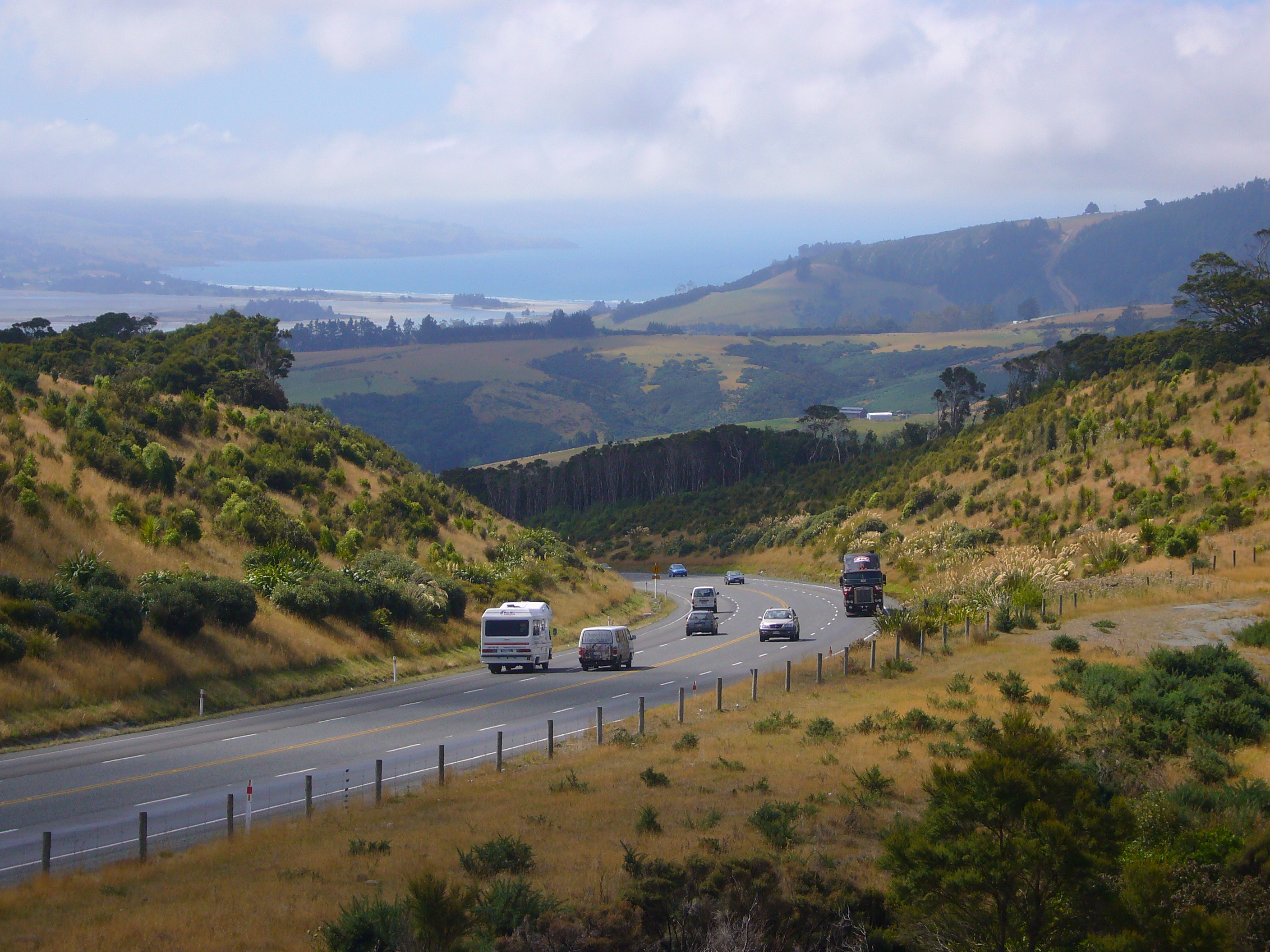
 Dunedin-Waitati Hwy looking north from near the Pigeon Flat Overbridge. Blueskin Bay is visible in the background
 Map showing Dunedin Waitati Hwy and the Dunedin Southern Motorway (marked in red - other parts of State Highway 1 are marked in white)
Dunedin-Waitati Highway (SH 1), formerly (and currently in official land-use planning contexts[1]) called Dunedin Northern Motorway, is a two to four-lane limited-access road which provides the main route north from the city of Dunedin, New Zealand. It was constructed in the 1950s[when?] to replace narrow, winding routes via Port Chalmers and Mount Cargill. The road is occasionally briefly closed by snowfall in winter.
Contents
Route
Point Coordinates
(links to map & photo sources)Notes Pine Hill terminus 45°50′59″S 170°30′34″E / 45.8498°S 170.5095°E Maxwellton Street bridge 45°50′18″S 170°30′40″E / 45.8383°S 170.5110°E Dryden Road bridge 45°49′04″S 170°31′02″E / 45.8179°S 170.5171°E Leith Valley Road bridge 45°48′42″S 170°31′09″E / 45.8117°S 170.5192°E Leith Saddle summit intersection 45°48′00″S 170°30′58″E / 45.8001°S 170.5161°ECoordinates: 45°48′00″S 170°30′58″E / 45.8001°S 170.5161°E Pigeon Flat Road bridge 45°47′29″S 170°32′27″E / 45.7914°S 170.5409°E Waitati Valley Road intersection 45°45′49″S 170°33′30″E / 45.7636°S 170.5582°E Waitati terminus 45°44′48″S 170°34′08″E / 45.7467°S 170.5688°E Dunedin-Waitati Highway is relatively steep and winding, traversing part of the Silverpeaks range of hills. It begins a short distance north-west from where the two main parts of Dunedin's central business district one-way street system combine near The Gardens Corner with a pair of bridges over the Water of Leith. The highway connects with Bank St and George St then climbs Pine Hill Rd to the northern Dunedin suburb of Pine Hill. From there it follows the northeastern side of the Leith Valley, then crosses the headwaters of the Leith before traversing the Leith Saddle and taking a roller-coaster-like course to the valley of the Waitati River, then to Waitati. Together with The Kilmog, a hill 5 kilometres (3.1 mi) north of Waitati, this is one of the two most notable hill sections of State Highway 1 south of Christchurch.
'Motorway' status and access
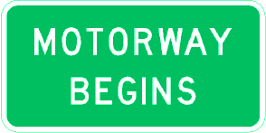
 These New Zealand motorway signs no longer appear on Dunedin-Waitati Highway
Dunedin-Waitati Highway was officially designated a motorway when it opened[when?] and is still colloquially referred to as such. "Motorway" signage was removed[when?] and the road lacks any indication of its former status other than "No Cycling/No Pedestrians" signs at Pine Hill and Waitati Valley. Apart from occasional overpasses, it does not resemble a freeway or motorway, rather a two to four-lane undivided limited-access road, and cyclists and pedestrians are allowed on the northern section.
Dunedin-Waitati Highway is a highway in terms of traffic regulations, while the land corridor is designated motorway under the New Zealand Government Roading Powers Act and town planning rules.[1]
There are occasional private property accesses along the 15 km length and two at-grade intersections: one at the Leith Saddle summit, with Leith Valley Road and Waitati Valley Road, the other at the lower end of Waitati Valley Road. Intersecting roads all have low traffic volumes and are unsealed. All other road crossings are grade separated on bridges with no road connections, at Maxwellton Street (which links the suburb of Glenleith with both Pine Hill and the summit of Mount Cargill), Leith Valley Road, Dryden Road, and Pigeon Flat Road; the last of these is the only bridge north of the saddle.
Improvements
Several parts of the highway were realigned or widened around 2000, most notably between the Pigeon Flat Overbridge and the start of the Waitati River floodplain.
Leith Saddle
 Leith Saddle is a strategic point where the motorway traverses a fragile alpine forest dominated by Libocedrus bidwillii (visible on the skyline at right). Proposed road works to straighten a dangerous corner here conflict with conservation values.
Transit New Zealand signalled in 2004 its a long term intention to re-align SH1 in the vicinity of Leith Saddle, which would require some removal of old-growth forest[2]
The forest here features a species of Libocedrus, variously called Pahautea, Kaikawaka or New Zealand cedar, Libocedrus bidwillii, which is unusual in this region of New Zealand.[3] Transit New Zealand stated in 2004 that Leith Saddle has 250% more accidents than average for the New Zealand State Highway network and that the accident rate increased by 50% in the ten years to 2004.[2] They said realignment here would reduce traffic delays, fuel use, crashes, and emissions of carbon dioxide and carbon monoxide.[2]
Waitati
The motorway originally ended at Waitati with a roundabout, which featured in the New Zealand film Goodbye Pork Pie. The roundabout has been[when?] removed, leaving a sharp curve with a T junction. In 2010, the New Zealand Transport Agency (the successor highway authority to Transit New Zealand) was given consent to realign the road here.[4]
See also
- List of motorways in New Zealand
References
- ^ a b When is a motorway not a motorway? on blueskin.co.nz news website, retrieved 2011-02-07
- ^ a b c Transit New Zealand leaflet Leith Saddle Realignment, 2004
- ^ Wildlife Feature on Orokonui Ecosanctuary website, retrieved 2009-06-10
- ^ "Council backs Waitati realignment". Otago Daily Times. 10 December 2010. http://www.odt.co.nz/news/dunedin/140123/council-backs-waitati-realignment. Retrieved 29 September 2011.
List of motorways and expressways in New Zealand Auckland Northern Motorway · Northwestern Motorway · Southern Motorway · Southwestern Motorway · Upper Harbour MotorwayWellington Rest of North Island South Island Christchurch Northern Motorway · Christchurch Southern Motorway · Christchurch-Lyttelton Motorway · Dunedin-Waitati Highway · Dunedin Southern MotorwayPast motorways/expressways Wanganui Metropolitan Motorway · Dunedin Northern MotorwayFuture motorways/expressways Penlink · Waterview Connection · Transmission Gully Motorway · Kapiti Expressway · Tauranga Eastern Motorway · Christchurch Southern MotorwayMajor infrastructure Categories:- Roads in New Zealand
- Motorways in New Zealand
- Transport in Dunedin
- Two-lane motorways


Wikimedia Foundation. 2010.