- Dungeness (Cumberland Island, Georgia)
-
Dungeness Historic District
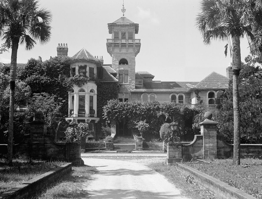
 Dungeness in 1958
Nearest city: St. Marys, Georgia Architect: Multiple Architectural style: Queen Anne, Shingle Style Governing body: National Park Service MPS: Cumberland Island National Seashore MRA NRHP Reference#: 84000920 Added to NRHP: February 13, 1984[1] Dungeness on Cumberland Island, Georgia, is a ruined mansion that is part of a historic district that was the home of several families significant in American history. James Oglethorpe first built on Cumberland Island in 1736, building a hunting lodge that he named Dungeness. The next Dungeness was designed by Revolutionary War hero Nathaniel Greene, who had acquired 11,000 acres (45 km2) of island land in exchange for a bad debt. His widow built a four-story tabby mansion in 1803 on a Timucuan shell mound. During the War of 1812 the island was occupied by the British, who used the house as a headquarters. In 1818 Henry Lee III, known as Lighthorse Harry Lee and father of Robert E. Lee, stayed at the house until his death, and was buried there for a time. This house was abandoned during the U.S. Civil War and burned in 1866.[2]
In the 1880s the property was purchased by Thomas M. Carnegie, brother of Andrew Carnegie, who began to build a new mansion on the site. The 59-room Queen Anne style mansion and grounds were completed after Carnegie's death in 1886. His wife Lucy continued to live at Dungeness and built other estates for her children including, Greyfield for Margaret Carnegie, Plum Orchard for George Lauder Carnegie, and Stafford Plantation. By this time, the Carnegies owned 90% of the island.
The Carnegies moved out of Dungeness in 1925. In 1959 the Dungeness mansion was destroyed by fire, alleged to be arson.[2] The ruins are today preserved by the National Park Service as part of Cumberland Island National Seashore. They were acquired by the Park Service in 1972.[3]
 Greene Cottage or Tabby House
The main house comprises a portion of the larger historic district, which includes servant's quarters, utility buildings, laundries, cisterns and a variety of other structures.[4] The district forms a planned, landscaped ensemble. The most significant supporting structure is the Tabby House or Nathaniel Greene Cottage, which dates to the Greene family's tenure.[3]
References
- ^ "National Register Information System". National Register of Historic Places. National Park Service. 2008-04-15. http://nrhp.focus.nps.gov/natreg/docs/All_Data.html.
- ^ a b "Dungeness (Cumberland Island, Ga.)". Digital Library of Georgia. 2009-01-14. http://dlg.galileo.usg.edu/meta/html/dlg/larc/meta_dlg_larc_jlc0344.html?Welcome.
- ^ a b "Dungeness Mansion Ruin". List of Classified Structures. National Park Service. 2009-01-14. http://www.hscl.cr.nps.gov/insidenps/report.asp?STATE=GA&PARK=CUIS&STRUCTURE=&SORT=&RECORDNO=18.
- ^ "Dungeness Negro Servants' Quarters". List of Classified Structures. National Park Service. 2009-01-14. http://www.hscl.cr.nps.gov/insidenps/report.asp?STATE=GA&PARK=CUIS&STRUCTURE=&SORT=&RECORDNO=32.
External links
- Dungeness, Cumberland Island, Cumberland Island, Camden County, GA: 6 photos, 4 data pages, at Historic American Building Survey
- General Nathaniel Greene Cottage, Cumberland Island, Cumberland Island, Camden County, GA: 3 drawings, 4 photos, 3 data pages, at Historic American Building Survey
National Register of Historic Places in Cumberland Island National Seashore Historic districts Dungeness Historic District | High Point-Half Moon Bluff Historic District | Plum Orchard Historic District | Rayfield Archeological District | Stafford Plantation Historic District | Table Point Archeological District
NRHP properties Duck House | Main Road
See also: National Register of Historic Places listings in Cumberland Island National Seashore U.S. National Register of Historic Places Topics Lists by states Alabama • Alaska • Arizona • Arkansas • California • Colorado • Connecticut • Delaware • Florida • Georgia • Hawaii • Idaho • Illinois • Indiana • Iowa • Kansas • Kentucky • Louisiana • Maine • Maryland • Massachusetts • Michigan • Minnesota • Mississippi • Missouri • Montana • Nebraska • Nevada • New Hampshire • New Jersey • New Mexico • New York • North Carolina • North Dakota • Ohio • Oklahoma • Oregon • Pennsylvania • Rhode Island • South Carolina • South Dakota • Tennessee • Texas • Utah • Vermont • Virginia • Washington • West Virginia • Wisconsin • WyomingLists by territories Lists by associated states Other  Category:National Register of Historic Places •
  Portal:National Register of Historic Places
Coordinates: 30°44′54″N 81°28′15″W / 30.748441°N 81.47087°W
Categories:- Historic districts in Georgia (U.S. state)
- Buildings and structures in Camden County, Georgia
- Houses in Georgia (U.S. state)
- Lee family residences
- Plantations in Georgia (U.S. state)
- Queen Anne architecture in Georgia (U.S. state)
- Ruins in the United States
- Shingle Style houses
- Cumberland Island National Seashore

Wikimedia Foundation. 2010.