- Mapiri Municipality
-
Mapiri Municipality — Municipality — Location of the Mapiri Municipality within Bolivia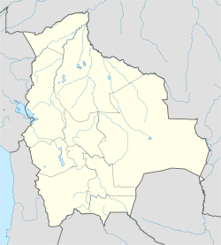
 Mapiri Municipality
Coordinates: 15°18′31″S 68°14′28″W / 15.3087°S 68.2412°WCoordinates: 15°18′31″S 68°14′28″W / 15.3087°S 68.2412°W Country  Bolivia
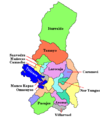
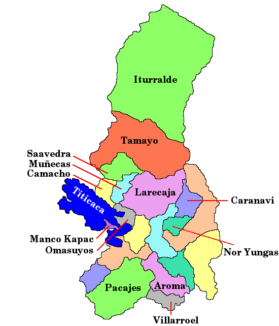
Department La Paz Department Province Larecaja Province Foundation Seat Mapiri Government - Mayor Enrique Calle Onorio (2007) - President Ramiro Jorge Vargas Orosco (2007) Area - Total 525.5 sq mi (1,361 km2) Population (2001) - Total 9,633 Mapiri Municipality is the seventh municipal section of the Larecaja Province in the La Paz Department, Bolivia. Its seat is Mapiri.
Languages
The languages spoken in the Mapiri Municipality are mainly Spanish, Quechua and Aymara.
Language Inhabitants Quechua 3.649 Aymara 1.767 Guaraní 6 Another native 7 Spanish 8.567 Foreign 17 Only native 363 Native and Spanish 4.653 Only Spanish 3.915 Ref.: obd.descentralizacion.gov.bo
References
External links
 La Paz Department
Capital: La Paz Provinces Abel Iturralde • Aroma • Bautista Saavedra • Caranavi • Camacho • Franz Tamayo • Gualberto Villarroel • Ingavi • Inquisivi • José Manuel Pando • Larecaja • Loayza • Los Andes • Manco Kapac • Murillo • Muñecas • Nor Yungas • Omasuyos • Pacajes • Sud Yungas
Municipalities
(and seats)Achacachi (Achacachi) • Achocalla (Achocalla) • Alto Beni (Caserío Nueve) • Ancoraimes (Ancoraimes) • Apolo (Apolo) • Aucapata (Aucapata) • Ayata (Ayata) • Ayo Ayo (Ayo Ayo) • Batallas (Batallas) • Cairoma (Cairoma) • Cajuata (Cajuata) • Calacoto (Calacoto) • Calamarca (Calamarca) • Caquiaviri (Caquiaviri) • Caranavi (Caranavi) • Catacora (Catacora) • Chacarilla (Chacarilla) • Charaña (Charaña) • Chulumani (Chulumani) • Chuma (Chuma) • Collana (Collana) • Colquencha (Colquencha) • Colquiri (Colquiri) • Comanche (Comanche) • Combaya (Combaya) • Copacabana (Copacabana) • Coripata (Coripata) • Coro Coro (Coro Coro) • Coroico (Coroico) • Curva (Curva) • Desaguadero (Desaguadero) • El Alto (El Alto) • Escoma (Escoma) • General Juan José Pérez (Charazani) • Guanay (Guanay) • Guaqui (Guaqui) • Huarina (Huarina) • Ichoca (Ichoca) • Inquisivi (Inquisivi) • Irupana (Irupana) • Ixiamas (Ixiamas) • Jesús de Machaca (Jesús de Machaca) • La Asunta (La Asunta) • La Paz (La Paz) • Laja (Laja) • Licoma Pampa (Licoma) • Luribay (Luribay) • Malla (Malla) • Mapiri (Mapiri) • Mecapaca (Mecapaca) • Mocomoco (Mocomoco) • Nazacara de Pacajes (Nazacara) • Palca (Palca) • Palos Blancos (Palos Blancos) • Papel Pampa (Papel Pampa) • Patacamaya (Patacamaya) • Pelechuco (Pelechuco) • Pucarani (Pucarani) • Puerto Acosta (Puerto Acosta) • Puerto Carabuco (Puerto Carabuco) • Puerto Pérez (Puerto Perez) • Quiabaya (Quiabaya) • Quime (Quime) • San Andrés de Machaca (San Andrés de Machaca) • San Buenaventura (San Buenaventura) • San Pedro de Curahuara (San Pedro de Curahuara de Carangas) • San Pedro de Tiquina (San Pedro de Tiquina) • Santiago de Callapa (Callapa) • Santiago de Huata (Santiago de Huata) • Santiago de Machaca (Santiago de Machaca) • Sapahaqui (Sapahaqui) • Sica Sica (Sica Sica) • Sorata (Sorata) • Tacacoma (Tacacoma) • Taraco (Taraco) • Teoponte (Teoponte) • Tiwanaku (Tiwanaku) • Tipuani (Tipuani) • Tito Yupanqui (Tito Yupanqui) • Umala (Umala) • Umanata (Umanata) • Viacha (Viacha) • Waldo Ballivián (Tumarapi) • Yaco (Yaco) • Yanacachi (Yanacachi)
Mountains Alpamayo Chico • Condoriri • Anallajsi • Ancohuma • Chachacomani • Chacaltaya • Illampu • Illimani • Huayna Potosí • MururataProtected areas Apolobamba • Cotapata • Madidi • Pilón Lajas
Departments of Bolivia Beni · Chuquisaca · Cochabamba · La Paz · Oruro · Pando · Potosí · Santa Cruz · Tarija
 Categories:
- La Paz Department, Bolivia geography stubs
- Municipalities of the La Paz Department, Bolivia

Wikimedia Foundation. 2010.