- Miracle Mile, Los Angeles
-
 The Miracle Mile
The Miracle Mile in Los Angeles, California, is an area in the Mid-Wilshire region consisting of an almost two-mile (3 km) stretch of Wilshire Boulevard between Fairfax and Western Avenues. It may also refer to the surrounding neighborhoods (including Park La Brea).
Contents
Geography
The Miracle Mile District is bordered by the Fairfax District on the north, Hancock Park on the northeast, Mid-City on the southeast, West Pico on the south, and Carthay on the southwest. The district's boundaries are roughly 3rd Street on the north, Highland Avenue on the east, San Vicente Boulevard on the south, and Fairfax Avenue on the west. Major thoroughfares include Wilshire and Olympic Boulevards, La Brea and Fairfax Avenues, and 6th Street. The district's ZIP codes are 90036 and parts of 90019.
History
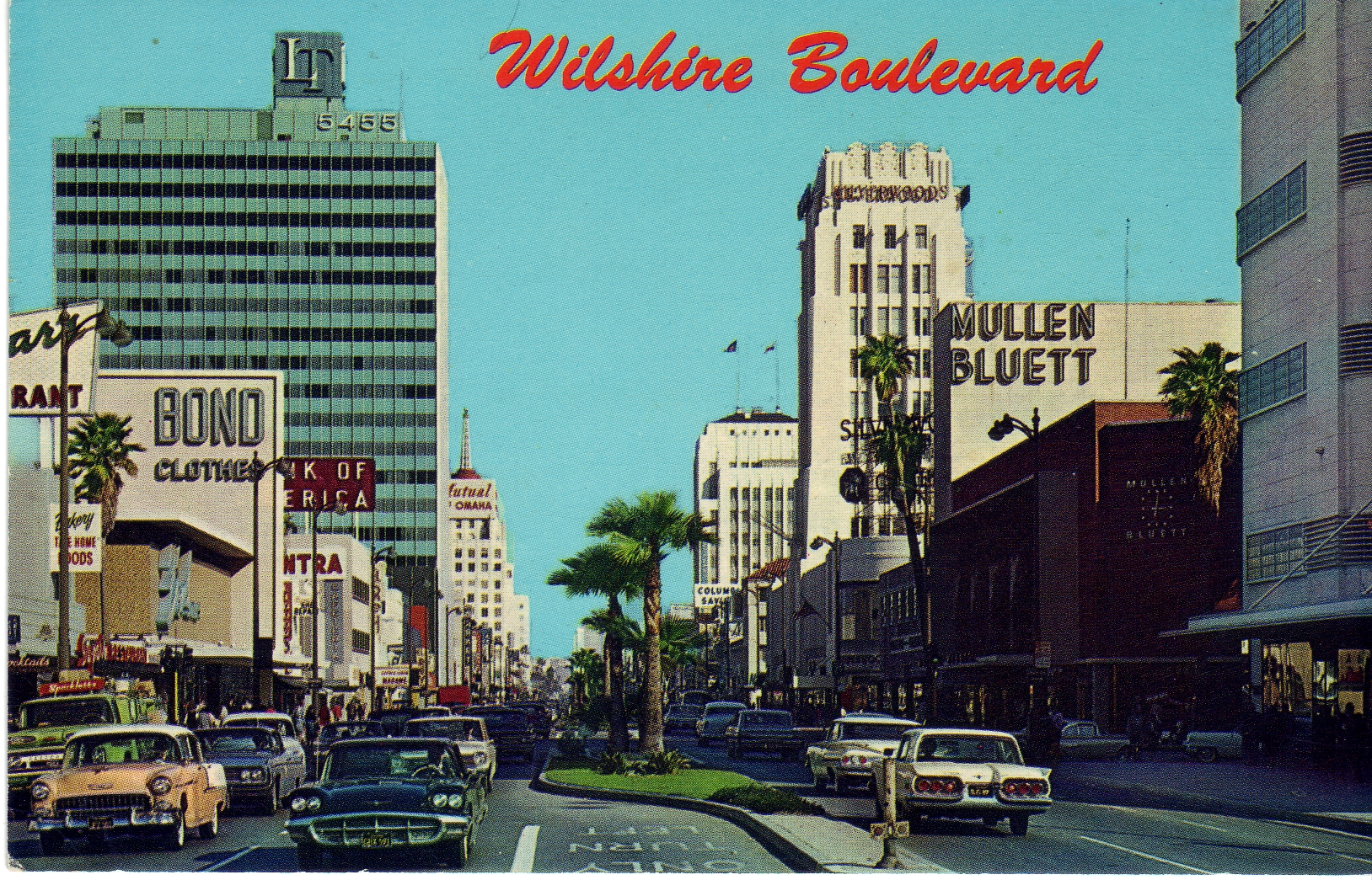
 The Miracle Mile district during the early 1960s.
In the early 1920s, Wilshire Boulevard west of Western Avenue was an unpaved farm road, extending through dairy farms and bean fields. Developer A.W. Ross saw potential for the area, and developed Wilshire as a commercial district to rival downtown Los Angeles.
Ross's insight was that the form and scale of his Wilshire strip should attract and serve automobile traffic rather than pedestrian shoppers. He applied this design both to the street itself and to the buildings lining it. Ross gave Wilshire various "firsts": dedicated left-turn lanes, the first timed traffic lights in the United States; he also required merchants to provide automobile parking lots, all to aid traffic flow. Major retailers such as Desmonds, Silverwood's, May Co., Coulter's, Mullen & Bluett, and Seibu eventually spread across Wilshire Boulevard from Fairfax to La Brea. Ross ordered that all building facades along Wilshire be engineered so as to be best seen through a windshield. This meant larger, bolder, simpler signage; longer buildings in a larger scale, oriented toward the boulevard; and architectural ornament and massing perceptible at 30 MPH (50 km/h) instead of at walking speed. These simplified building forms were driven by practical requirements, but contributed to the stylistic language of Art Deco and Streamline Moderne.
 The old May Co. building, now LACMA West, marks the western border of Miracle Mile's "Museum Row"
Ross's moves were unprecedented, a huge commercial success, and proved historically influential. Ross had invented the car-oriented urban form—what Reyner Banham called "the linear downtown" model later adopted across the United States. The moves also contributed to Los Angeles' reputation as a city dominated by the car. A sculptural bust of Ross stands at 5800 Wilshire, with the inscription, "A. W. Ross, founder and developer of the Miracle Mile. Vision to see, wisdom to know, courage to do."
As wealth and newcomers poured into the fast-growing city, Ross' parcel became one of Los Angeles's most desirable areas. Acclaimed as "America's Champs-Élysées,"[1] this stretch of Wilshire near the La Brea Tar Pits was named "Miracle Mile" for its improbable rise to prominence. Although the preponderance of shopping malls and the development in the 1960s of financial and business districts in downtown and Century City lessened the Miracle Mile's importance as a retail and business center, the area has retained its vitality thanks to the addition of several museums and commercial high-rises. The Petersen Automotive Museum, Los Angeles County Museum of Art, (LACMA) A+D Museum: Los Angeles, and La Brea Tar Pits museums, among others, positioned "Museum Row" on the Miracle Mile as a rival to Exposition Park.
The Art Deco bank recently joined an elite group of local buildings that are on the National Register of Historic Places. It was designed by the architecture firm of Morgan, Walls & Clements, which did the Wiltern Theatre, the El Capitan, and many other notable Los Angeles buildings; 5209 Wilshire was built in 1929.
Traffic
 The L.A. County Museum of Art is located in Miracle Mile
The Miracle Mile District is one of the city's more densely populated areas, but is considerably more affluent than other high-density neighborhoods like Westlake and Koreatown. As a result, traffic congestion in the district is high even by the standards of Los Angeles. To alleviate problems and provide an alternative to automobiles for commuters, proposals have been made to extend Los Angeles Metro's Purple Line subway to Fairfax Avenue or points further west, from its current terminus at Western Avenue in Koreatown. However, a federal ban on tunneling operations in the area was passed at the behest of the district's Congressional representative Henry Waxman after a 1985 explosion, caused by the buildup of methane seeping up through the district's long-depleted oil wells, destroyed a department store. The ban was implemented despite the fact that methane deposits abound in most of Los Angeles. In late 2005, the ban was overturned, owing to tunneling techniques that make it possible to mitigate the methane concern. A westerly extension of the subway has recently been supported by many civic officials in Los Angeles, Beverly Hills, and Santa Monica,[citation needed] the three cities through which the extension may run. In early 2008, the project— which is destined to terminate in Santa Monica—received $5 billion in federal funds. In late 2008, Measure R passed releasing $10 billion in reserve funds to start working on all public transit projects in the city of L.A. as well as the most desired "Subway to the sea" project, which will run from downtown L.A. to Santa Monica. This ambitious project was proposed over ten years ago and will take anywhere from 5 to 10 years to complete.
Education
The area is within the Los Angeles Unified School District. The area is within Board District 4.[2]
Cultural references
The opening credits sequence of blaxploitation film Coffy(1973) is a night drive on Miracle Mile.
A line from Billy Joel's first Billboard number-one single "It's Still Rock & Roll To Me" asks "Are you gonna cruise the Miracle Mile?"
The 1988 cult film Miracle Mile is set in the area.
The Miracle Mile section of Wilshire Blvd. is incinerated building by building in the 1997 film Volcano, when lava explodes out of the La Brea Tar Pits and surges down Museum Row, but is stopped before any homes along the street are destroyed. At the film's end, the new volcano is christened 'Mt. Wilshire'.
The New Radicals' 1998 hit "You Get What You Give" also makes reference to the Miracle Mile district.
Pearl of the Quarter, the seventh track from Steely Dan's 1973 album Countdown to Ecstasy, contains a reference to the Miracle Mile.
See also
- Harold A. Henry, Los Angeles City Council president active in improving the Miracle Mile
References
- ^ Miracle Mile Review. Fodor's Retrieved April 12, 2009.
- ^ Board District 4 Map. Los Angeles Unified School District. Retrieved on November 24, 2008.
The Steely Dan song, 'Pearl of the Quarter' mentions walking alone down the miracle mile.
External links
- Los Angeles Times, Real Estate section, Neighborly Advice column: "[Miracle Mile:] "Older, it's got plenty of mileage left" (13 June 2004)
- Historic Photo Essay of the Miracle Mile District
- Miracle Mile Residential Association
- Miracle Mile Action Committee and Miracle Mile Safety Patrol
City of Los Angeles Topics History • Transportation • Culture • Landmarks • Historic sites • Skyscrapers • Demographics • Crime • Sports • Media • Music • Notable people • Lists
Government Flag • Mayors • City Council • Other elected officials • Airport • DWP • Fire Department • Police • Public schools • Libraries • Port • TransportationRegions Downtown • Eastside/Northeast • Harbor Area • Greater Hollywood • Westlake & Silver Lake/Los Feliz • San Fernando and Crescenta Valleys • South Los Angeles • Westside • WilshireWilshire area, Los Angeles Districts and
neighborhoodsArlington Heights • Carthay • Country Club Park • Fairfax District • Hancock Park • Harvard Heights • Koreatown • Lafayette Square • Larchmont • Little Ethiopia • Mid-City • Miracle Mile • Park La Brea • Picfair Village • Wilshire Center • Wilshire Park • Windsor Square

Points of
interestDowntown • Eastside/Northeast • Harbor Area • Greater Hollywood • Westlake & Silver Lake/Los Feliz • San Fernando and Crescenta Valleys • South Los Angeles • Westside • Wilshire
Categories:- Neighborhoods in Los Angeles, California
- Los Angeles Historic Preservation Overlay Zones
- Art in the Greater Los Angeles Area
- Art gallery places


Wikimedia Foundation. 2010.