- Municipal Borough of Slough
-
Coordinates: 51°30′36″N 0°35′35″W / 51.51°N 0.593056°W
Slough Motto: FIDUCIA ET VI (By confidence and strength) 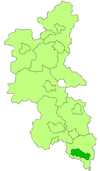
Slough within Buckinghamshire in 1971Geography Status Local government district (1863–1894)
Urban district (1894–1938)
Municipal borough (1938–1974)1911 area 1,684 acres (6.81 km2) 1931 area 6,145 acres (24.87 km2) 1961 area 6,202 acres (25.10 km2) History Created 1863 Abolished 1974 Succeeded by Slough Demography 1911 population
- 1911 density14,982
8.9/acre1931 population
- 1931 density33,530
5.5/acre1961 population
- 1961 density80,781
13.0/acre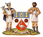
Coat of armsSlough was, from 1863 to 1974, a local government district in southern Buckinghamshire, England.[1] It became an urban district in 1894 and was incorporated as a municipal borough in 1938. It was abolished in 1974 and now forms part of the borough of Slough in Berkshire.
Contents
Formation
The Local Government Act 1858 was adopted in 1863 for town of Slough, that was partly in the parishes of Upton cum Chalvey and Stoke Poges, creating a local government district governed by Slough Local Board of Health.
Following the Local Government Act 1894, its area was reconstituted as an urban district consisting of the civil parishes of Slough and Stoke-in-Slough. The local authority became Slough Urban District Council. Slough absorbed Stoke-in-Slough in 1896.[1] The remaining portions of Upton cum Chalvey and Stoke Poges became part of Eton Rural District.
Boundary changes
The district was subject to a number of boundary changes, which incorporated territory from Eton Rural District.
In 1900 the urban district gained part of Langley Marish and more of the Upton cum Chalvey civil parishes.
In 1930, as part of a county review order, it gained 4,461 acres (18.05 km2) of Burnham, Dorney, Farnham Royal, Horton, Langley Marish and Stoke Poges.
In 1931, as part of another county review order, it gained 57 acres (0.23 km2) of Farnham Royal and Stoke Poges.
Incorporation
In 1938, under the provisions of the Municipal Corporations Act 1882, the urban district was incorporated by royal charter as a municipal borough and the local authority became Slough Borough Council.
Coat of arms
A coat of arms and motto were granted on 3 September 1938. The coat of arms depicts a swan, the county emblem of Buckinghamshire and brick-axes, indicating local brick-making. The sign for Uranus is taken from the arms of the Herschel family, referring to the discovery of the planet by astronomer William Herschel. The supporters are symbols of trade and industry. The motto Fiducia et vi means 'By confidence and strength'.[2]
Abolition
The borough was abolished in 1974 and its former area was combined with part of Eton Rural District to form the borough of Slough in Berkshire.[1]
References
 Administrative map of England in 1931.
- ^ a b c Youngs, Frederic (1979). Guide to the Local Administrative Units of England. I: Southern England. London: Royal Historical Society. ISBN 0901050679.
- ^ "Buckinghamshire (obsolete)". Civic Heraldry of England and Wales. http://www.civicheraldry.co.uk/bucks_ob.html.
External links
 History of local government districts in Buckinghamshire
Ancient boroughs Amersham · Aylesbury · Brill · Buckingham · Chepping Wycombe · Fenny Stratford · Great Marlow · Newport Pagnell · Olney · WendoverIncorporated boroughs Urban districts Aylesbury · Beaconsfield · Bletchley · Chesham · Eton · Fenny Stratford · Linslade · Marlow · Newport Pagnell · Slough · Stratford and Wolverton · WolvertonRural districts Amersham · Buckingham · Eton · Hambleden · Long Crendon · Newport Pagnell · Stratford and Wolverton · Wing · WycombeCivil parishes Boundary changes affecting Buckinghamshire Categories:- History of Slough
- Districts of England created by the Local Government Act 1894
- Local government in Buckinghamshire
- Municipal boroughs of England
- Districts of England abolished by the Local Government Act 1972


Wikimedia Foundation. 2010.