- Nash Island Light
-
Nash Island Light 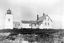
US Coast Guard photo Location Pleasant Bay, Maine Coordinates 44°27′51.1″N 67°44′50.1″W / 44.464194°N 67.74725°WCoordinates: 44°27′51.1″N 67°44′50.1″W / 44.464194°N 67.74725°W Original lens 4th order Fresnel lens Nash Island Light is a lighthouse on Nash Island at the entrance to Pleasant Bay in Maine.
Contents
History
It was first established in 1838. The present structure was built in 1874. It was replaced by a buoy in 1982. The USCG historical site says that it included a one room schoolhouse, although that's hard to understand on a small offshore island.
Keepers[1]
- John Wass (1847–1853)
- Daniel Curtis (1853-unknown)
- Enos D. Wass (1865–1872)
- Edwin K. Heath (1872–1876)
- Nehemiah Guptill (1876–1881)
- Roscoe G. Lophaus (1881–1883)
- Charles S. Holt (1883–1902)
- Osmond Cummings
- Allen Carter Holt (1910–1916)
- John Purington (1916–1935)
- Edwin Pettegrow (c. 1930s)
- Larson Alley (unknown-1947)
- Edward Wallace (1947–1958)
References
- ^ a b "Historic Light Station Information and Photography: Maine". United States Coast Guard Historian's Office. 2009-08-06. http://www.uscg.mil/history/weblighthouses/LHME.asp.
External links
Lighthouses of Maine Avery Rock Light · Baker Island Light · Bass Harbor Head Light · Bear Island Light · Blue Hill Bay Light · Boon Island Light · Browns Head Light · Burnt Coat Harbor Light · Burnt Island Light · Cape Elizabeth Lights · Cape Neddick Light · Crabtree Ledge Light · The Cuckolds Light · Curtis Island Light · Deer Island Thorofare Light · Dice Head Light · Doubling Point Light · Doubling Point Range Lights · Eagle Island Light · Egg Rock Light · Fiddler's Reach Fog Signal · Fort Point Light · Franklin Island Light · Goat Island Light · Goose Rocks Light · Great Duck Island Light · Grindel Point Light · Halfway Rock Light · Hendricks Head Light · Heron Neck Light · Indian Island Light · Isle Au Haut Light · Kennebunkport Breakwater Light · Ladies Delight Light · Libby Island Light · Little River Light · Lubec Channel Light · Manana Island Sound Signal Station · Marshall Point Light · Matinicus Rock Light · Monhegan Island Light · Moose Peak Light · Mount Desert Light · Narraguagus Light · Nash Island Light · Owls Head Light · Pemaquid Point Light · Perkins Island Light · Petit Manan Light · Pond Island Light · Portland Breakwater Light · Portland Head Light · Prospect Harbor Point Light · Pumpkin Island Light · Ram Island Light · Ram Island Ledge Light · Rockland Harbor Breakwater Light · Saddleback Ledge Light · Saint Croix River Light · Seguin Light · Spring Point Ledge Light · Squirrel Point Light · Tenants Harbor Light · Two Bush Island Light · West Quoddy Head Light · Whaleback Light · Whitehead Light · Whitlocks Mill Light · Winter Harbor Light · Wood Island Light Portland Head Light
 Categories:
- Lighthouses in Maine
- Buildings and structures completed in 1874
- Lighthouses in Washington County, Maine
- United States lighthouse stubs

Wikimedia Foundation. 2010.