- Narraguagus Light
-
Narraguagus Light 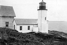
Location Narraguagus Bay Year first constructed 1853 Deactivated 1934 Foundation Stone Construction Granite blocks Tower shape Cylindrical attached to workroom Markings / pattern White Narraguagus Light Station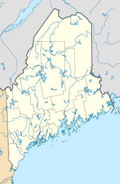

Nearest city: Milbridge, Maine Coordinates: 44°27′21.5″N 67°49′52.35″W / 44.455972°N 67.8312083°WCoordinates: 44°27′21.5″N 67°49′52.35″W / 44.455972°N 67.8312083°W Area: 1.5 acres (0.61 ha) Built: 1853 Architect: US Army Corps of Engineers Governing body: Private MPS: Light Stations of Maine MPS NRHP Reference#: 87002022[2] Added to NRHP: November 20, 1987 Narraguagus Light is a lighthouse on Narraguagus Bay, Maine. It was established in 1853 and deactivated in 1934. It is on Pond Island (one of several in Maine), at the entrance to Narraguagus Bay and the river of the same name.
Narraguagus Light was listed on the National Register of Historic Places as "Narraguagus Light Station" on November 20, 1987, reference number 87002022.[2]
References
- ^ "Historic Light Station Information and Photography: Maine". United States Coast Guard Historian's Office. 2009-08-06. http://www.uscg.mil/history/weblighthouses/LHME.asp.
- ^ a b "National Register Information System". National Register of Historic Places. National Park Service. 2009-03-13. http://nrhp.focus.nps.gov/natreg/docs/All_Data.html.
Lighthouses of Maine Avery Rock Light · Baker Island Light · Bass Harbor Head Light · Bear Island Light · Blue Hill Bay Light · Boon Island Light · Browns Head Light · Burnt Coat Harbor Light · Burnt Island Light · Cape Elizabeth Lights · Cape Neddick Light · Crabtree Ledge Light · The Cuckolds Light · Curtis Island Light · Deer Island Thorofare Light · Dice Head Light · Doubling Point Light · Doubling Point Range Lights · Eagle Island Light · Egg Rock Light · Fiddler's Reach Fog Signal · Fort Point Light · Franklin Island Light · Goat Island Light · Goose Rocks Light · Great Duck Island Light · Grindel Point Light · Halfway Rock Light · Hendricks Head Light · Heron Neck Light · Indian Island Light · Isle Au Haut Light · Kennebunkport Breakwater Light · Ladies Delight Light · Libby Island Light · Little River Light · Lubec Channel Light · Manana Island Sound Signal Station · Marshall Point Light · Matinicus Rock Light · Monhegan Island Light · Moose Peak Light · Mount Desert Light · Narraguagus Light · Nash Island Light · Owls Head Light · Pemaquid Point Light · Perkins Island Light · Petit Manan Light · Pond Island Light · Portland Breakwater Light · Portland Head Light · Prospect Harbor Point Light · Pumpkin Island Light · Ram Island Light · Ram Island Ledge Light · Rockland Harbor Breakwater Light · Saddleback Ledge Light · Saint Croix River Light · Seguin Light · Spring Point Ledge Light · Squirrel Point Light · Tenants Harbor Light · Two Bush Island Light · West Quoddy Head Light · Whaleback Light · Whitehead Light · Whitlocks Mill Light · Winter Harbor Light · Wood Island Light Portland Head Light
U.S. National Register of Historic Places Topics Lists by states Alabama • Alaska • Arizona • Arkansas • California • Colorado • Connecticut • Delaware • Florida • Georgia • Hawaii • Idaho • Illinois • Indiana • Iowa • Kansas • Kentucky • Louisiana • Maine • Maryland • Massachusetts • Michigan • Minnesota • Mississippi • Missouri • Montana • Nebraska • Nevada • New Hampshire • New Jersey • New Mexico • New York • North Carolina • North Dakota • Ohio • Oklahoma • Oregon • Pennsylvania • Rhode Island • South Carolina • South Dakota • Tennessee • Texas • Utah • Vermont • Virginia • Washington • West Virginia • Wisconsin • WyomingLists by territories Lists by associated states Other Categories:- Historic districts in Maine
- Buildings and structures completed in 1853
- Lighthouses on the National Register of Historic Places in Maine
- Lighthouses in Washington County, Maine
- United States lighthouse stubs
- Maine Registered Historic Place stubs


Wikimedia Foundation. 2010.