- National Register of Historic Places listings in Chesterfield County, Virginia
-
This list includes properties and districts listed on the National Register of Historic Places in Chesterfield County, Virginia. Click the "Map of all coordinates" link to the right to view a Google map of all properties and districts with latitude and longitude coordinates in the table below.[1]
-
- This National Park Service list is complete through NPS recent listings posted November 10, 2011.[2]
[3] Landmark name [4] Image Date listed Location City or town Summary 1 Azurest South December 30, 1993 2900 Boisseau St.
37°14′24″N 77°25′09″W / 37.24°N 77.419167°WPetersburg 2 Beach Station February 22, 2008 11410 & 11400 Beach Rd.
37°21′20″N 77°35′42″W / 37.355556°N 77.595°WChesterfield Boundary decrease (listed March 24, 2010): 11410 & 11400 Beach Rd. 3 Bellona Arsenal 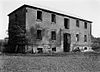
May 6, 1971 Off VA 673, NW of jct. with Rte. 147
37°33′13″N 77°37′02″W / 37.553611°N 77.617222°WMidlothian 4 Bellwood December 12, 1978 Address Restricted Richmond Plantation house originally known as Sheffields and later as Auburn Chase[5] 5 Bethel Baptist Church February 22, 1999 1100 Huguenot Springs Rd.
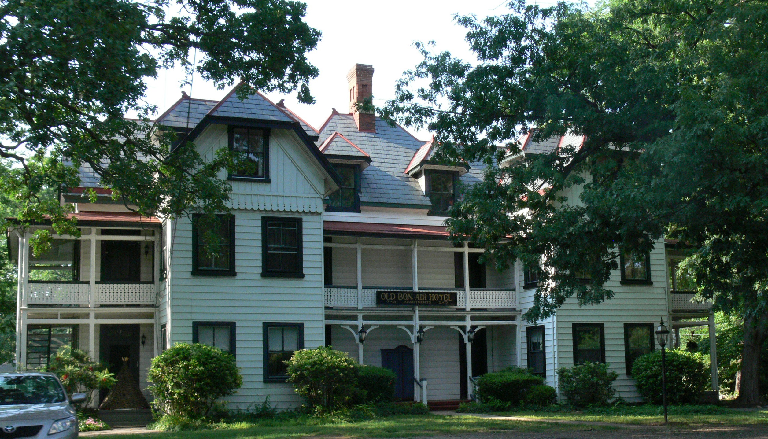
37°30′43″N 77°42′41″W / 37.511944°N 77.711389°WMidlothian 6 Bon Air Historic District 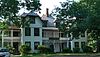
November 15, 1988 Roughly bounded by Forest Hill Rd., N. Robert, W. Bon View Dr., and McRae Rd.
37°31′34″N 77°33′26″W / 37.526111°N 77.557222°WRichmond 7 Bridge at Falling Creek October 12, 1995 US 1/301 at Falling Cr.
37°26′22″N 77°26′22″W / 37.439444°N 77.439444°WRichmond 8 Castlewood November 21, 1976 VA 10
37°22′31″N 77°30′11″W / 37.375278°N 77.503056°WChesterfield 9 Chester Presbyterian Church November 21, 1976 Jct. of Osborne Rd. and VA 10
37°21′33″N 77°25′53″W / 37.359167°N 77.431389°WChester 10 Chesterfield County Courthouse and Courthouse Square August 18, 1992 N side VA 10, 350 ft. E of jct. with VA 655
37°22′35″N 77°30′26″W / 37.376389°N 77.507222°WChesterfield 11 Dale's Pale Archeological District January 19, 2007 South shore of James R., Chesterfield County Park Chester 12 Dinwiddie County Pullman Car July 3, 1991 Hallsboro Yard, NE of jct. of VA 606 and VA 671
37°28′59″N 77°44′10″W / 37.483056°N 77.736111°WMidlothian 13 Eppington November 12, 1969 S of jct. of VA 621 and 602
37°18′04″N 77°42′27″W / 37.301111°N 77.7075°WWinterpock 14 Falling Creek Ironworks Archeological Site March 29, 1995 Address Restricted Richmond 15 Hallsboro Store March 10, 2005 920 Hallsboro Rd.
37°29′26″N 77°43′35″W / 37.490556°N 77.726389°WMidlothian 16 Hallsborough Tavern March 17, 1980 W of Midlothian on U.S. 60
37°30′31″N 77°42′40″W / 37.508611°N 77.711111°WMidlothian 17 Keswick 
December 19, 1974 NE of Powhatan off VA 711
37°33′39″N 77°39′52″W / 37.560833°N 77.664444°WPowhatan Also listed in the NRHP NRIS database in Powhatan, Virginia 18 Kingsland September 18, 1975 1608 Willis Rd.
37°24′14″N 77°24′48″W / 37.403889°N 77.413333°WChimney Corner 19 Magnolia Grange March 17, 1980 VA 10
37°22′30″N 77°30′27″W / 37.375°N 77.5075°WChesterfield 20 Olive Hill April 3, 1975 0.5 mi. W of Matoaca off VA 36
37°13′34″N 77°29′48″W / 37.226111°N 77.496667°WMatoaca 21 Pleasant View June 10, 1975 1.5 mi. E of Midlothian on VA 677
37°30′42″N 77°37′18″W / 37.511667°N 77.621667°WMidlothian 22 Point of Rocks March 10, 2005 1005 Point of Rocks Rd.
37°19′18″N 77°20′17″W / 37.321667°N 77.338056°WChester 23 Proctor Creek, Jefferson Davis Highway Marker September 12, 2008 9300 Block of Jefferson Davis Hwy.
37°23′50″N 77°25′53″W / 37.397303°N 77.431303°WRichmond 24 Swift Creek Mill 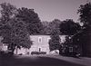
January 11, 1974 N of Colonial Heights on U.S. 1
37°17′00″N 77°24′42″W / 37.283333°N 77.411667°WColonial Heights 25 Town of Bermuda Hundred Historic District November 8, 2006 Both sides of Bermuda Hundred and Allied Rds.
37°20′33″N 77°16′22″W / 37.3425°N 77.272778°WChester 26 Vawter Hall and Old President's House May 7, 1980 Virginia State University campus
37°14′04″N 77°25′05″W / 37.234444°N 77.418056°WEttrick See also
- National Register of Historic Places listings in Virginia
- National Register of Historic Places listings in Colonial Heights, Virginia
- National Register of Historic Places listings in Petersburg, Virginia
- National Register of Historic Places listings in Richmond, Virginia
- List of National Historic Landmarks in Virginia
References
- ^ The latitude and longitude information provided in this table was derived originally from the National Register Information System, which has been found to be fairly accurate for about 99% of listings. For about 1% of NRIS original coordinates, experience has shown that one or both coordinates are typos or otherwise extremely far off; some corrections may have been made. A more subtle problem causes many locations to be off by up to 150 yards, depending on location in the country: most NRIS coordinates were derived from tracing out latitude and longitudes off of USGS topographical quadrant maps created under the North American Datum of 1927, which differs from the current, highly accurate WGS84 GPS system used by Google maps. Chicago is about right, but NRIS longitudes in Washington are higher by about 4.5 seconds, and are lower by about 2.0 seconds in Maine. Latitudes differ by about 1.0 second in Florida. Some locations in this table may have been corrected to current GPS standards.
- ^ "National Register of Historic Places: Weekly List Actions". National Park Service, United States Department of the Interior. Retrieved on November 10, 2011.
- ^ Numbers represent an ordering by significant words. Various colorings, defined here, differentiate National Historic Landmark sites and National Register of Historic Places Districts from other NRHP buildings, structures, sites or objects.
- ^ "National Register Information System". National Register of Historic Places. National Park Service. . http://nrhp.focus.nps.gov/natreg/docs/All_Data.html.
- ^ "Bellwood National Register of Historic Places Nomination Form". Virginia Department of Historic Resources. 1978. http://www.dhr.virginia.gov/registers/Counties/Chesterfield/020-0007_Bellwood_1978_Final_Nomination.pdf. Retrieved 21 December 2008.
External links
U.S. National Register of Historic Places Topics Lists by states Alabama • Alaska • Arizona • Arkansas • California • Colorado • Connecticut • Delaware • Florida • Georgia • Hawaii • Idaho • Illinois • Indiana • Iowa • Kansas • Kentucky • Louisiana • Maine • Maryland • Massachusetts • Michigan • Minnesota • Mississippi • Missouri • Montana • Nebraska • Nevada • New Hampshire • New Jersey • New Mexico • New York • North Carolina • North Dakota • Ohio • Oklahoma • Oregon • Pennsylvania • Rhode Island • South Carolina • South Dakota • Tennessee • Texas • Utah • Vermont • Virginia • Washington • West Virginia • Wisconsin • WyomingLists by territories Lists by associated states Other Municipalities and communities of Chesterfield County, Virginia CDPs Bellwood | Bensley | Bon Air | Brandermill | Chester | Chesterfield Court House | Enon | Ettrick | Manchester | Matoaca | Meadowbrook | Rockwood | Woodlake

Unincorporated
communitiesCategories:- Chesterfield County, Virginia
- National Register of Historic Places in Virginia
- Virginia-related lists
-


Wikimedia Foundation. 2010.