- National Register of Historic Places listings in Columbia County, Washington
-
National Register of Historic Places listings in Columbia County, Washington
List of entries on the National Register of Historic Places in Columbia County, Washington
-
- This National Park Service list is complete through NPS recent listings posted November 10, 2011.[1]
Contents
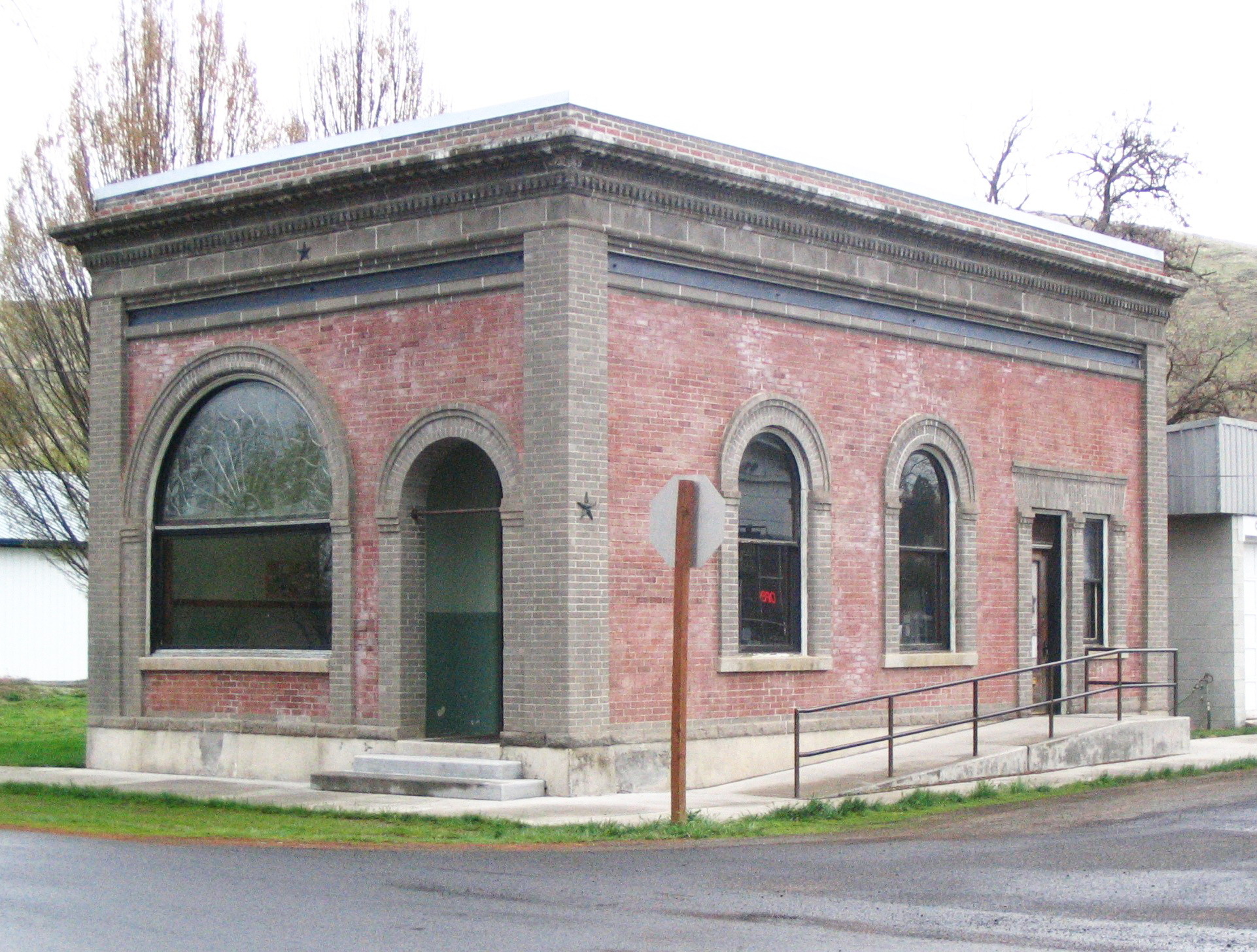
[2] Landmark name [3] Image Date listed Location City or town Summary 1 Bank of Starbuck 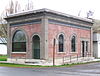
February 8, 1978 Main and McNeil Sts.
46°31′11″N 118°07′35″W / 46.519722°N 118.126389°WStarbuck 2 A. H. Bishop House August 13, 1986 622 E. Richmond
46°19′33″N 117°58′31″W / 46.325833°N 117.975278°WDayton 3 John Brining House August 13, 1986 410 N. First
46°19′23″N 117°58′54″W / 46.323056°N 117.981667°WDayton 4 Columbia County Courthouse 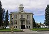
February 10, 1975 341 E. Main
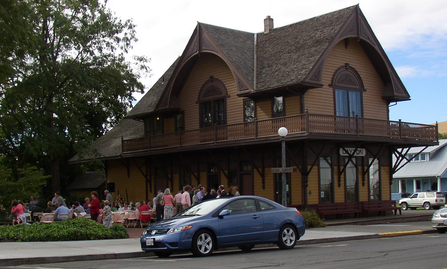
46°19′17″N 117°58′40″W / 46.321389°N 117.977778°WDayton 5 Dayton Depot 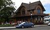
November 19, 1974 2nd and Commercial Sts.
46°19′15″N 117°58′44″W / 46.320833°N 117.978889°WDayton 6 Dexter House No. 1 August 13, 1986 515 S. Fourth
46°19′06″N 117°58′18″W / 46.318333°N 117.971667°WDayton 7 Dexter House No. 2 August 13, 1986 507 N. Third
46°19′28″N 117°58′47″W / 46.324444°N 117.979722°WDayton 8 Downtown Dayton Historic District May 31, 1999 Roughly along Main St., from Front to third Sts.
46°19′15″N 117°58′41″W / 46.320833°N 117.978056°WDayton 9 Frank Flintner House August 13, 1986 214 S. Sixth
46°19′15″N 117°58′18″W / 46.320833°N 117.971667°WDayton 10 Guernsey-Sturdevant Building 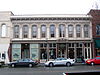
January 12, 1993 225 E. Main St.
46°19′12″N 117°58′45″W / 46.32°N 117.979167°WDayton 11 Grover J. Israel House August 13, 1986 305 S. Sixth
46°19′16″N 117°58′17″W / 46.321111°N 117.971389°WDayton 12 Mancel Kelley House August 13, 1986 1301 S. Fifth
46°18′37″N 117°57′41″W / 46.310278°N 117.961389°WDayton 13 Mill House August 13, 1986 504 N. First
46°19′25″N 117°58′57″W / 46.323611°N 117.9825°WDayton 14 Andrew Nilsson House August 13, 1986 312 E. Patit
46°19′23″N 117°58′45″W / 46.323056°N 117.979167°WDayton 15 Dr. Marcel Pietrzycki House August 13, 1986 415 E. Clay
46°19′16″N 117°58′31″W / 46.321111°N 117.975278°WDayton 16 Snake River Bridge 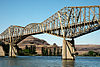
July 16, 1982 N of SR 12
46°35′28″N 118°13′28″W / 46.591111°N 118.224444°WLyons Ferry Historic Bridges and Tunnels in Washington TR 17 South Side Historic District August 13, 1986 Roughly bounded by Clay, Third, Park, and First Sts.
46°19′04″N 117°58′33″W / 46.317778°N 117.975833°WDayton 18 J. A. Thronson House August 13, 1986 510 S. Fourth
46°19′05″N 117°58′19″W / 46.318056°N 117.971944°WDayton 19 Washington Street Historic District August 13, 1986 Roughly Washington St. between Patit Creek and Third St.
46°19′19″N 117°58′49″W / 46.321944°N 117.980278°WDayton 20 Jacob Weinhard House August 13, 1986 NW of Dayton
46°19′17″N 117°59′47″W / 46.321389°N 117.996389°WDayton See also
References
- ^ "National Register of Historic Places: Weekly List Actions". National Park Service, United States Department of the Interior. Retrieved on November 10, 2011.
- ^ Numbers represent an ordering by significant words. Various colorings, defined here, differentiate National Historic Landmark sites and National Register of Historic Places Districts from other NRHP buildings, structures, sites or objects.
- ^ "National Register Information System". National Register of Historic Places. National Park Service. . http://nrhp.focus.nps.gov/natreg/docs/All_Data.html.
U.S. National Register of Historic Places Topics Lists by states Alabama • Alaska • Arizona • Arkansas • California • Colorado • Connecticut • Delaware • Florida • Georgia • Hawaii • Idaho • Illinois • Indiana • Iowa • Kansas • Kentucky • Louisiana • Maine • Maryland • Massachusetts • Michigan • Minnesota • Mississippi • Missouri • Montana • Nebraska • Nevada • New Hampshire • New Jersey • New Mexico • New York • North Carolina • North Dakota • Ohio • Oklahoma • Oregon • Pennsylvania • Rhode Island • South Carolina • South Dakota • Tennessee • Texas • Utah • Vermont • Virginia • Washington • West Virginia • Wisconsin • WyomingLists by territories Lists by associated states Other  Category:National Register of Historic Places •
  Portal:National Register of Historic PlacesCategories:
- National Register of Historic Places in Washington (state) by county
- Columbia County, Washington
-


Wikimedia Foundation. 2010.