- National Register of Historic Places listings in Hill County, Texas
-
List of Registered Historic Places in Hill County, Texas
This is intended to be a complete list of properties and districts listed on the National Register of Historic Places in Hill County, Texas. The locations of National Register properties and districts (at least for all showing latitude and longitude coordinates below) may be seen in a Google map by clicking on "Map of all coordinates".[1]
-
- This National Park Service list is complete through NPS recent listings posted November 10, 2011.[2]
[3] Landmark name [4] Image Date listed Location City or town Summary 1 J. T. Baker Farmstead March 17, 1992 1.2 mi (1.9 km). N of Blum between TX 174 and the Nolan R.
32°09′30″N 97°23′18″W / 32.158333°N 97.388333°WBlum 2 Bear Creek Shelter Site October 19, 1978 Address Restricted Huron 3 Buzzard Cave July 18, 1974 Address Restricted Lake Whitney 4 Farmers National Bank March 30, 1984 68 W. Elm St.
32°00′37″N 97°07′51″W / 32.010278°N 97.130833°WHillsboro 5 Gebhardt Bakery March 30, 1984 119 E. Franklin St.
32°00′42″N 97°07′44″W / 32.011667°N 97.128889°WHillsboro 6 Grimes Garage March 30, 1984 110 N. Waco St.
32°00′44″N 97°07′47″W / 32.012222°N 97.129722°WHillsboro 7 Grimes House March 30, 1984 Country Club Rd. and Corporation St.
32°00′46″N 97°06′51″W / 32.012778°N 97.114167°WHillsboro 8 Hill County Courthouse 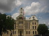
June 21, 1971 Courthouse Sq.
32°00′40″N 97°07′50″W / 32.011111°N 97.130556°WHillsboro 9 Hill County Jail May 28, 1981 N. Waco St.
32°00′51″N 97°07′46″W / 32.014167°N 97.129444°WHillsboro 10 Hillsboro Cotton Mills March 30, 1984 220 N. Houston St.
32°00′46″N 97°08′05″W / 32.012778°N 97.134722°WHillsboro 11 Hillsboro Residential Historic District July 9, 1984 Roughly bounded by Country Club Rd., Thompson, Corsicana, Pleasant, Franklin, and Elm Sts.
32°00′46″N 97°07′14″W / 32.012778°N 97.120556°WHillsboro 12 Kyle Shelter July 9, 1974 Address Restricted Lake Whitney Estates 13 McKenzie Site November 25, 1977 Address Restricted Hillsboro 14 Missouri-Kansas-Texas Company Railroad Station December 19, 1979 Covington St.
32°00′46″N 97°07′52″W / 32.012778°N 97.131111°WHillsboro 15 Old Rock Saloon March 30, 1984 58 W. Elm St.
32°00′37″N 97°07′49″W / 32.010278°N 97.130278°WHillsboro 16 Pictograph Cave March 13, 1974 Address Restricted Lake Whitney 17 Sheep Cave July 9, 1974 Address Restricted Blum 18 Sturgis National Bank March 30, 1984 S. Waco and W. Elm Sts.
32°00′37″N 97°07′48″W / 32.010278°N 97.13°WHillsboro 19 Tarlton Building March 30, 1984 110 E. Franklin St.
32°00′41″N 97°07′44″W / 32.011389°N 97.128889°WHillsboro 20 Joe E. Turner House April 13, 1977 3 mi (4.8 km). E of Itasca on SR 934
32°10′22″N 97°05′30″W / 32.172778°N 97.091667°WItasca 21 U.S. Post Office March 30, 1984 118 S. Waco St.
32°00′35″N 97°07′48″W / 32.009722°N 97.13°WHillsboro 22 Western Union Building March 30, 1984 107 S. Covington St.
32°00′42″N 97°07′44″W / 32.011667°N 97.128889°WHillsboro See also
- Registered Historic Places in Texas, Counties H-J
References
- ^ The latitude and longitude information provided in this table was derived originally from the National Register Information System, which has been found to be fairly accurate for about 99% of listings. For about 1% of NRIS original coordinates, experience has shown that one or both coordinates are typos or otherwise extremely far off; some corrections may have been made. A more subtle problem causes many locations to be off by up to 150 yards, depending on location in the country: most NRIS coordinates were derived from tracing out latitude and longitudes off of USGS topographical quadrant maps created under North American Datum of 1927, which differs from the current, highly accurate GPS system used by Google maps. Chicago is about right, but NRIS longitudes in Washington are higher by about 4.5 seconds, and are lower by about 2.0 seconds in Maine. Latitudes differ by about 1.0 second in Florida. Some locations in this table may have been corrected to current GPS standards.
- ^ "National Register of Historic Places: Weekly List Actions". National Park Service, United States Department of the Interior. Retrieved on November 10, 2011.
- ^ Numbers represent an ordering by significant words. Various colorings, defined here, differentiate National Historic Landmark sites and National Register of Historic Places Districts from other NRHP buildings, structures, sites or objects.
- ^ "National Register Information System". National Register of Historic Places. National Park Service. . http://nrhp.focus.nps.gov/natreg/docs/All_Data.html.
U.S. National Register of Historic Places Topics Lists by states Alabama • Alaska • Arizona • Arkansas • California • Colorado • Connecticut • Delaware • Florida • Georgia • Hawaii • Idaho • Illinois • Indiana • Iowa • Kansas • Kentucky • Louisiana • Maine • Maryland • Massachusetts • Michigan • Minnesota • Mississippi • Missouri • Montana • Nebraska • Nevada • New Hampshire • New Jersey • New Mexico • New York • North Carolina • North Dakota • Ohio • Oklahoma • Oregon • Pennsylvania • Rhode Island • South Carolina • South Dakota • Tennessee • Texas • Utah • Vermont • Virginia • Washington • West Virginia • Wisconsin • WyomingLists by territories Lists by associated states Other  Category:National Register of Historic Places •
  Portal:National Register of Historic PlacesCategories:
- Hill County, Texas
- National Register of Historic Places in Texas
- Buildings and structures in Hill County, Texas
-

Wikimedia Foundation. 2010.