- Norwichtown
-
Norwichtown Historic District
 Old School House

Location: Roughly bounded by Huntington Ln., Scotland Rd., and Washington, Town and E. Town Sts., Norwich, Connecticut Coordinates: 41°32′52″N 72°5′33″W / 41.54778°N 72.0925°WCoordinates: 41°32′52″N 72°5′33″W / 41.54778°N 72.0925°W Architect: Multiple Architectural style: Colonial, Georgian Governing body: Local NRHP Reference#: 73001951
[1]Added to NRHP: January 17, 1973 Norwichtown is an historic neighborhood in the city of Norwich, Connecticut. It is generally the area immediately north of the Yantic River between I-395 and Route 169.[citation needed]
The portion of the neighborhood from the Norwichtown Green and east of it is a locally designated historic district that was also listed on the National Register of Historic Places in 1973 as the Norwichtown Historic District.[2] The district includes 48 contributing buildings and one other contributing site over an 110 acres (45 ha) area.
The earliest settlement of Norwich, in 1659, was in Norwichtown. Initial settlement, by 35 English settlers who bought land from the Mohegans, was centered around the Norwichtown Green.[3][4][5]
The Green is triangular in shape, with an area of about 1.75 acres (0.71 ha). It is surrounded by shade trees and bordered by Town Street, East Town Street and Elm Avenue. These streets are lined with 18th and 19th houses and shops that face the Green.[2] There are four houses in Norwichtown that were built in the 17th century: the 1660 Bradford-Huntington House, built circa 1660; the Olmstead-Lathrop House, dating to circa 1659-1745; Leffingwell House Museum, built circa 1675; and the Simon Huntington House, built circa 1690. The First Congregational Church, built in the Federal style in 1801, was the third building to house the local congregation.[3][5] Many older homes in the district have been converted to commercial use. The John Mason School is now the central administration for the Norwich Public School System. North of the town's first schoolhouse is the Colonial Cemetery where four Connecticut governors are buried. Four houses from the 17th century remain standing north of the Green area is Meeting House Hill, a cliff of large rocks that is also known as the Meeting House Rocks. It was on this cliff that the village's second and third meetinghouses were established, with the site used as a lookout point.[2] The memorial on top of the rocks and pathway are cared for by the First Congregational Church.
Five buildings included in the historic district are separately listed on the National Register of Historic Places. These are the saltbox Leffingwell Inn, the Joseph Carpenter Silversmith Shop, built circa 1772-1774; the Dr. Daniel Lathrop School, one of Connecticut's oldest remaining brick schoolhouses, which dates to 1782; the Bradford-Huntington House at 16 Huntington Lane; and the Gen. Jedidiah Huntington House at 23 E. Town Street.[4]
Norwichtown was the old center of Norwich, when the town was settled primarily as a farming community in the late 17th century. By the early 18th century, the focus of Norwich became the harbor facilities in the adjacent Chelsea neighborhood east and south of the town center, and eventually the 'center' of Norwich became the small urban center at Chelsea, which was also ringed with industrial mills. The establishment of the city of Norwich in 1784 centered on the Chelsea neighborhood necessitated the distinction of calling the old town center 'Norwichtown'. The city of Norwich was consolidated with the town of Norwich in 1952 relegating Norwichtown to become a residential neighborhood of the city of Norwich.
Samuel Huntington, signer of the Declaration of Independence, president of the Continental Congress, first President of the United States under the Articles of Confederation, and governor of Connecticut, lived in Norwichtown. His house is located to the east of the Green and he is buried in Norwichtown's colonial era cemetery.[6] Samuel Huntington Elementary School on West Town Street in Norwichtown, a public school operated by Norwich Public Schools, is named for him.[6][7]
Fairview Reservoir, one of Norwich's backup reservoirs, is between Canterbury Turnpike and Scotland Road in Norwichtown.
See also
- Neighborhoods of Norwich, Connecticut
- National Register of Historic Places listings in New London County, Connecticut
References
- ^ "National Register Information System". National Register of Historic Places. National Park Service. 2009-03-13. http://nrhp.focus.nps.gov/natreg/docs/All_Data.html.
- ^ a b c Norwichtown Green, TownGreens.com, accessed September 26, 2009
- ^ a b Walking Guide to Historic Norwichtown (1995), The Last Green Valley, Inc.
- ^ a b Norwichtown Historic District[dead link], National Register of Historic Places Red Book
- ^ a b Carol Davidge and Erwin Goldstein, "Norwichtown Green & Old Burying Grounds," Walking Guide to the Quinebaug and Shetucket Rivers Valley National Heritage Corridor, page 5
- ^ a b Bill Stanley, Huntington a forgotten giant in American history, Norwich Bulletin, July 13, 2008
- ^ Samuel Huntington Elementary School website
U.S. National Register of Historic Places Topics Lists by states Alabama • Alaska • Arizona • Arkansas • California • Colorado • Connecticut • Delaware • Florida • Georgia • Hawaii • Idaho • Illinois • Indiana • Iowa • Kansas • Kentucky • Louisiana • Maine • Maryland • Massachusetts • Michigan • Minnesota • Mississippi • Missouri • Montana • Nebraska • Nevada • New Hampshire • New Jersey • New Mexico • New York • North Carolina • North Dakota • Ohio • Oklahoma • Oregon • Pennsylvania • Rhode Island • South Carolina • South Dakota • Tennessee • Texas • Utah • Vermont • Virginia • Washington • West Virginia • Wisconsin • WyomingLists by territories Lists by associated states Other Municipalities and communities of New London County, Connecticut Consolidated cities 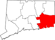
Towns Non-consolidated city Boroughs Unincorporated
communitiesBaltic | Burnetts Corner | Conning Towers-Nautilus Park | Gales Ferry | Graniteville | Greeneville | Groton Long Point | Jordan | Long Hill | Lords Point | Mystic | Niantic | Noank | Norwichtown | Old Mystic | Oswegatchie | Oxoboxo River | Palmertown | Pawcatuck | Poquetanuck | Poquonock Bridge | Preston City | Quaker Hill | Taftville | Uncasville
Categories:- NRHP articles with dead external links
- Historic districts in Connecticut
- Georgian architecture in Connecticut
- Neighborhoods in Connecticut
- Norwich, Connecticut
- Historic districts in New London County, Connecticut


Wikimedia Foundation. 2010.