Oostelijke Polders

Oostelijke Polders
Oostelijke Polders
—  Resort  —
Map showing the resorts of Nickerie District.
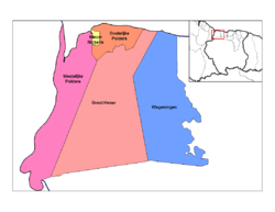
Country  Suriname
District Nickerie District
Time zone AST (UTC-3)

Oostelijke Polders is a resort in Suriname, located in the Nickerie District. Its population at the 2004 census was 6,778.[1]

References

Coordinates: 5°51′31″N 56°53′07″W / 5.8587°N 56.8853°W / 5.8587; -56.8853


Wikimedia Foundation. 2010.

Игры ⚽ Поможем сделать НИР

Look at other dictionaries:

  • Oostelijke Polders — Distrito de Nickerie con Oostelijke Polder …   Wikipedia Español

  • Westelijke Polders — Distrito de Nickerie con Westelijke Polder …   Wikipedia Español

  • Nickerie District — Map of Suriname showing Nickerie district Nickerie is a district of Suriname, on the north west coast. Nickerie s capital city is Nieuw Nickerie, the second largest city in the country. Other towns include Washoda and Wageningen. The district… …   Wikipedia

  • Nickerie — Capital Nieuw Nickerie Entidad Distrito …   Wikipedia Español

  • Districts of Suriname — Suriname This article is part of the series: Politics and government of Suriname Constitution President …   Wikipedia

  • Commewijne District — Map of Suriname showing Commewijne district Commewijne is a district of Suriname, located on the right bank of the Suriname River. Commewijne s capital city is Nieuw Amsterdam. Alliance is another major town. The district has a population of… …   Wikipedia

  • Coronie District — Map of Suriname showing Coronie district Coronie is a district of Suriname, situated on the coast. Coronie s capital city is Totness, with other towns including Corneliskondre, Friendship, Jenny. The district border the Atlantic Ocean to the… …   Wikipedia

  • Marowijne District — Map of Suriname showing Marowijne district Marowijne is a district of Suriname, located on the north east coast. Marowijne s capital city is Albina, with other towns including Moengo and Wanhatti. The district borders the Atlantic Ocean to the… …   Wikipedia

  • Saramacca District — Coordinates: 5°46′57″N 55°37′29″W / 5.7825°N 55.62472°W / 5.7825; 55.62472 …   Wikipedia

  • Moengo —   Resort   Map showing the resorts of Marowijne District …   Wikipedia

Share the article and excerpts

Direct link
Do a right-click on the link above
and select “Copy Link”