- Arendal
Infobox_Kommune
name = Arendal
idnumber = 0906

county = Aust-Agder
landscape = Sørlandet
capital = Arendal
demonym = Arendalitt
language =Bokmål
munwebpage = www.arendal.kommune.no
governor = Torill Rolstad Larsen (Ap)
governor_as_of = 2003
arearank = 289
area = 270
arealand = 255
areapercent = 0.08
population_as_of = 2004
populationrank = 19
population = 39,826
populationpercent = 0.86
populationdensity = 155
populationincrease = 2.0
lat_deg = 58 | lat_min = 28 | lat_sec = 56 | lon_deg = 8 | lon_min = 46 | lon_sec = 57
utm_zone = 32V | utm_northing = 6482449 | utm_easting = 0487326 | geo_cat = town(39,495)Audio|Arendal.ogg|Arendal is a town and municipality in the county of
Aust-Agder ,Norway . The town is the administrative center of Aust-Agder county, and belongs to the geographical region ofSørlandet . The municipality is bordered to the southwest byGrimstad , to the northwest byFroland , and to the northeast byTvedestrand . The town of Arendal was established as a municipality on 1 January 1838 (seeformannskapsdistrikt ). The rural municipality ofBarbu was merged with Arendal on 1 January 1902. The rural municipalities ofHisøy ,Moland ,Tromøy andØyestad were merged with Arendal on 1 January 1992.General information
Origin of the name
The
Old Norse form of the name was probably "Arnardalr". The first element is thegenitive case of "orn" which means "eagle " and the last element is "dalr" which means "valley " or "dale".Coat-of-arms
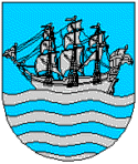
The coat-of-arms were granted on 7 November 1924 (based upon an older seal). The arms show a
sailing ship as a symbol for the importance of fisheries andsailing to the local economy. A ship appeared on the oldest known seal of the town, dating back to the 17th century. In the late 19th and early 20th century the arms showed theship in the upper part and a landscape with theCoat of arms of Norway in the base of theshield . [cite web|url=http://www.ngw.nl/int/nor/a/arendal.htm|author=Norske Kommunevåpen|date=1990|title=Nye kommunevåbener i Norden|accessdaymonth=3 October|accessyear=2008]History
Arendal was established in the middle of the 1500s, and was then called "Arendall". At that time it had no formal town status.
When
Kristiansand was founded by King Christian IV in 1641, he granted the citizens a monopoly on all trade in Aust-Agder andVest-Agder . This grant, intended to subsidize Kristiansand and its fortifications, placed existing towns in a difficult position. Both towns and the peasants in the up country protested the hardships this caused. As a result, Arendal received royal permission in 1622 to continue as a loading-place for timber until a means could be found to transfer its trade to Kristiansand.The town was given market city privileges in 1723. However the peasants in the surrounding district, who by law were to sell their goods only at Arendal, were smuggling their goods out on cutters and selling them in
Denmark , in the Baltic, and in Britain.This continued until 1735, when Arendal was granted a full town charter. This charter, combined with Danish imposition of a monopoly on
corn imports, caused greatpoverty and starvation among the peasants in the surrounding districts, leading to several famous rebellions.As a result of the rebellions, the age of privileges for towns like Kristiansand and Arendal came to an apparent end in 1768 by royal
proclamation . But the problems did not end then; a farmer,Kristian Jensson Lofthus , inVestre Moland led a rebellion in 1786 which resulted in the government actually remedying some of the most repressive trade policies, but Lofthus died in prison. The charges against Lofthus were that he dealt in corn and other commodities to the detriment to Arendal’s privileges.Shipping ,shipbuilding , and timber trade as well asmining andironworks were important branches of industry in Aust-Agder county for many centuries, especially in the Arendal region. Frequent contacts with the world abroad put their mark on our culture and traditions. In 1880, it was the land's biggest port in terms of tonnage handled. At the end of the 19th century, Arendal was recognized as a major shipping centre with many wealthy shipowners. In 1939, it had the 4th largest Norwegian tanker fleet; onlyOslo ,Bergen , andStavanger were larger.Today the town has small boat manufacturing, mechanical industry, electronics industry as well as one of the world's largest
silicon carbide refining plants.Townscape
In the middle of the town centre is an area with wooden houses dating back to the 1600s. This area is called Tyholmen, and is what is left of buildings from before the 19th century. The inner harbour of Arendal is Pollen, where the fish market, pubs, and restaurants are located.
"Store Torungen" lighthouse
The
lighthouse "Store Torungen" is located on an island outside Arendal. It was constructed in 1844 and electrified in 1914. It is 34.3 meters high and contains a 2nd order lens. It is reachable by a 55 minute boat trip from the town centre. The lighthouse is still in use."Lille Torungen" lighthouse
The lighthouse "Lille Torungen" is situated on a small island outside Arendal. The lighthouse is 28.9 meters high. Lille Torungen and Store Torungen were constructed as twin lighthouses, and both are located in the Arendal shipping lane.
Culture
The institution "Canal Street - Arendal Jazz and Blues" was established in 2001, but has been arranged since 1996, at that time by the name of Arendal Jazz and Blues Festival. The popularity of the arrangement has been steadily increasing. New in 2007 is
Hove Festival located on the IslandTromøy just outside Arendal town. It has the potential to become the largest festival scene in Norway with an audience of up to 20,000.Geography
Arendal is the type locality of the mineral
Babingtonite , which was first described from specimens discovered here in 1824. [ [http://www.mindat.org/min-478.html Babingtonite at Mindat.org] ]Merdø
The island of Merdø, an island far from the coast facing the
Skagerrak , was a major export port in the 17th and 18th centuries and now has amuseum , a kiosk, and several beaches. There is regular boat service from Arendal to the island every day during the summer season.Transportation
Apart from being a port town, Arendal lies immediately southeast of the E18 highway. The
Arendalsbanen railway line runs toNelaug where it connects withSørlandsbanen .Famous residents
*
Sam Eyde (1866-1940), Industrialist
*Øystein Grødum (1977), Speedskater
*Bård Torstensen (1961),Guitarist for heavy metal/rap bandClawfinger Twin cities
*flagicon|Latvia
Rezekne ,Latvia
*flagicon|DenmarkSilkeborg ,Denmark
*flagicon|SwedenKalmar ,Sweden
*flagicon|FinlandSavonlinna ,Finland
*flagicon|IcelandÁrborg ,Iceland See also
*
UNEP/GRID-Arendal References
External links
* [http://www.arendal.com/web/ontime.asp?doc_id=24&lang=en Arendal official tourist information]
* [http://rlb.no/tourist/kommune/0906/info/ Arendal tourist information from Reiselivsbasen]
* [http://www.grida.no/ UNEP/GRID-Arendal, UN Environment Programme office in Arendal]
* [http://maps.google.com/maps?ie=UTF8&om=1&ll=58.456714,8.777561&spn=0.062324,0.159645 Arendal on Google Maps]In Norwegian only
* [http://www.arendal.kommune.no/ Municipality of Arendal]
* [http://www.agderposten.no/ Agderposten — The leading newspaper covering Aust-Agder, with base in Arendal]
* [http://portal.fkarendal.no/ Arendal Football Club]
* [http://www.arendal.kommune.no/austagder/arendal/arendal_bibliotek.nsf/ Arendal Public Library]
* [http://www.aaks.no/ County museum & archiv: Aust-Agder kulturhistoriske senter]
* [http://www.noregur.is/misc/webcams.aspx?wid=58&id=-1&lang= Webcam of Arendal centre]
* [http://www.canalstreet.no/ Canal Street - Arendal Jazz and Blues festival]Other languages
* [http://www.reuber-norwegen.de/AustAgder/FramesAustAgderKarte.html Map of Aust-Agder including Arendal municipality]
Wikimedia Foundation. 2010.