- Mount Spokane
-
Mount Spokane 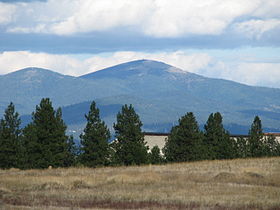
Mount Spokane as seen from northeast SpokaneElevation 5,887 ft (1,794 m) NAVD 88[1] Prominence 3,503 ft (1,068 m) [2] Location Spokane County, Washington, USA

Range Selkirk Mountains Coordinates 47°55′25″N 117°06′44″W / 47.923599289°N 117.112179347°WCoordinates: 47°55′25″N 117°06′44″W / 47.923599289°N 117.112179347°W[1] Topo map USGS Mount Spokane 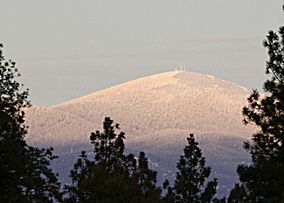 The peak of Mount Spokane in winter
Mount Spokane (elevation 5,883 feet / 1,793 metres) is a mountain located northeast of Spokane, Washington. It's summit is the highest point in Spokane County,[2] and it is one of the tallest peaks in the Inland Northwest. Mount Spokane is surrounded by Mount Spokane State Park, the largest of Washington's State Parks at 13,919 acres (56.33 km2).
One of the well known features is a bald spot on the corner of the west and south parts of the mountain.
A non-profit organization operates the Mount Spokane Ski and Snowboard Park, located on the southwest portion of the mountain.
Summary of Mount Spokane State Park history
1909 Frances Cook, owner of the summit, builds a toll road to within 3 miles (4.8 km) of the summit. 1927 Mt. Spokane State Park is officially dedicated at 1500 acres (6.1 km²). 1929 H. Cowles, Jr. donates 640 acres (2.6 km²) of land to the park. 1930s The Spokane Ski Club, the Selkirk Ski Club, and the Spokane Mountaineers purchase over 500 acres (2 km²) on the mountain for construction of lodges, rope-tows, and ski jump hills. The road is completed to the summit. 1934 Vista House is built by the Civilian Conservation Corps crew from Riverside State Park. 1935 CCC sets up camp on Beauty Mountain to improve the road and construct other facilities. 1939 The Spokane Chapter of the Conservation League buys 320 acres (1.3 km²) for the park for $1500 (south half of Section 21) to save virgin timber from logging and fire. 1946 The first double chair lift in the world is put into operation on the south face of the summit.[citation needed] 1952 A master plan is proposed for the park which includes over 24,000 acres (97 km²) and designates all of Mt. Spokane proper for downhill ski purposes. This proposal is not implemented. 1953 KXLY-TV becomes operational from the summit. 1955 Lodge #1 and Chairlift #1 are constructed. 1961 Concessionaire A.E.Mettler constructs Lodge #2 and Lift #2 1965 Another master plan is developed by State Parks to include 11,592 acres (46.9 km²) of land, 958 acres (3.9 km²) of which were allocated for general outdoor recreation with the remainder to be administered as a natural environment area. This plan is not adopted by the Parks Commission. 1974 Mt. Spokane Park’s official classification is changed from recreation area to state park and a new philosophy is applied: State Parks are to continuously service man’s spiritual, mental, and leisure time physical needs through the use of selected outstanding natural resources. This is to be accomplished by providing a full range of non-urban outdoor educational and recreational services and opportunities to a wide range of users with diversified interests and needs. 1978 A coordinated trail system plan is developed to, among other things, reduce conflicting recreational uses by specific allocation of park lands to user groups. The plan quickly became out of date and was never fully implemented. 1985 The Parks Commission formally designates the Ragged Ridge Natural Area within Mt. Spokane State Park. 1993 The Park contains about 13,643 acres (55.2 km²) of land, not including Quartz Mountain. Most of this land was donated or obtained during the Great Depression through property forfeitures. The Mt. Spokane State Park Alpine Ski Area Working Group Interface Subcommittee issues a report concerning the future of the Park. Among other things, it recommends a comprehensive planning process. 1994 State Parks proposes to classify areas of the Park as Natural Forest Areas. Several alternatives are proposed. The Mt. Spokane Planning Task Force Steering Committee is formed and issues its report. The group recommends a comprehensive planning process as well as the formation of a permanent, local Park advisory committee. 1995 Mt. Spokane State Park Advisory Committee appointed by Parks Commission begins monthly meetings in Spokane. Friends of Mt. Spokane State Park also formed. 1997 Mt. Spokane 2000, a non-profit group of local businesses and civic leaders, is approved as the new concessionaire for the alpine ski area to replace the Mt. Spokane Ski Corporation which operated the area for 20 years. 1999 A Classification and Management Plan (CAMP) process is started for the Park. New land classifications approved including about 10% as Recreation Area, about 58% as Resource Recreation Area, less than 1% as Heritage Area, about 22% as Natural Forest Area, about 4% as Natural Area Preserve, and about 5% as yet unclassified pending completion of the Ski Area Plan and further Commission consideration. 2009 Traditional Peace Blessing, sponsored by the Spokane Interfaith Council, including a Tibetan lama and a representative of the Spokane people.[3] References
- ^ a b "Y". NGS data sheet. U.S. National Geodetic Survey. http://www.ngs.noaa.gov/cgi-bin/ds_mark.prl?PidBox=SV1719.
- ^ a b "Mount Spokane, Washington". Peakbagger.com. http://www.peakbagger.com/peak.aspx?pid=3056.
- ^ Moses, Barry (Sulustu) (July 25, 2009). "Peace Blessing". Sulustu. http://sulustu.blogspot.com/2009/07/peace-blessing.html. Retrieved September 19, 2011.
External links
- "Mount Spokane". Geographic Names Information System, U.S. Geological Survey. http://geonames.usgs.gov/pls/gnispublic/f?p=gnispq:3:::NO::P3_FID:1512684.
- "Mount Spokane state park". Washington State Parks. http://www.parks.wa.gov/parks/?selectedpark=Mount%20Spokane.
Protected Areas of Washington Federal National ParksNational MonumentsEbey's Landing National Historical Reserve · Fairhaven Historic District · Pioneer Square Historic District · Vancouver National Historic Reserve Historic District
National Recreation AreasNational Wildlife RefugesColumbia · Conboy Lake · Copalis · Dungeness · Flattery Rocks · Franz Lake · Grays Harbor · Julia Butler Hansen Refuge for the Columbian White-Tailed Deer · Lewis and Clark · Little Pend Oreille · McNary · Nisqually · Pierce · Protection Island · Quillayute Needles · Ridgefield · Saddle Mountain · San Juan Islands · Steigerwald Lake · Toppenish · Turnbull · Umatilla · Willapa
National WildernessAlpine Lakes · Boulder River · Brothers · Buckhorn · Clearwater · Colonel Bob · Glacier Peak · Glacier View · Goat Rocks · Henry M. Jackson · Indian Heaven · Juniper Dunes · Lake Chelan-Sawtooth Ridge · Mount Adams · Mount Baker · Mount Rainier · Mount Skokomish · Noisy-Diobsud · Norse Peak · Olympic · Pasayten · Salmo-Priest · San Juan · Stephen Mather · Tatoosh · Trapper Creek · Washington Islands · Wenaha–Tucannon · Wild Sky · William O. Douglas · Wonder Mountain
State Alta Lake · Anderson Lake · Battle Ground Lake · Bay View · Beacon Rock · Belfair · Birch Bay · Blake Island · Blind Island · Bogachiel · Bottle Beach · Bridgeport · Bridle Trails · Brooks Memorial · Cama Beach · Camano Island · Camp Wooten Environmental Learning Center · Cape Disappointment · Centennial Trail · Clark Island · Columbia Hills · Columbia Plateau Trail · Conconully · Crawford · Curlew Lake · Cutts Island · Damon Point · Daroga · Dash Point · Deception Pass · Dosewallips · Doug's Beach · Eagle Island · Fay Bainbridge · Federation Forest · Fields Spring · Flaming Geyser · Fort Casey · Fort Columbia · Fort Ebey · Fort Flagler · Fort Okanogan · Fort Simcoe · Fort Townsend · Fort Ward · Fort Worden · Ginkgo Petrified Forest · Goldendale Observatory · Grayland Beach · Griffin Bay · Griffiths-Priday · Harstine Island · Hope Island (Mason County) · Hope Island (Skagit County) · Ike Kinswa · Illahee · Iron Horse · James Island · Jarrell Cove · Joemma Beach · Jones Island · Joseph Whidbey · Kanaskat-Palmer · Kinney Point · Kitsap Memorial · Kopachuck · Lake Chelan · Lake Easton · Lake Sammamish · Lake Sylvia · Lake Wenatchee · Larrabee · Leadbetter Point · Lewis and Clark · Lewis and Clark Trail · Lime Kiln Point · Lincoln Rock · Manchester · Maryhill · Matia Island · McMicken Island · Millersylvania · Moran · Mount Pilchuck · Mount Spokane · Mystery Bay · Nine Mile Recreation Area · Nolte · Ocean City · Olallie · Olmstead Place · Osoyoos Lake · Pacific Beach · Pacific Pines · Palouse Falls · Paradise Point · Patos Island · Peace Arch · Pearrygin Lake · Penrose Point · Peshastin Pinnacles · Pleasant Harbor · Posey Island · Potholes · Potlatch · Rainbow Falls · Rasar · Reed Island · Riverside · Rockport · Sacajawea · Saint Edward · Saltwater · Scenic Beach · Schafer · Seaquest · Sequim Bay · Shine Tidelands · Skagit Island · Skull Island · South Whidbey · Spencer Spit · Squak Mountain · Squilchuck · Steamboat Rock · Steptoe Battlefield · Steptoe Butte · Stretch Point · Stuart Island · Sucia Island · Sun Lakes · Tolmie · Triton Cove · Turn Island · Twanoh · Twenty-Five Mile Creek · Twin Harbors · Upright Channel · Wallace Falls · Wanapum Recreational Area · Wenatchee Confluence · Westport Light · Yakima Sportsman
Ahtanum · Capitol · Elbe Hills · Green Mountain · Loomis · Loup Loup · Tahoma · Tahuya · Tiger Mountain · Yacolt Burn
Admiralty Inlet · Badger Gulch · Bald Hill · Barker Mountain · Bone River · Camas Meadows · Carlisle Bog · Castle Rock · Charley Creek · Chehalis River Surge Plain · Chopaka Mountain · Clearwater Bogs · Cleveland Shrub Steppe · Columbia Falls · Columbia Hills · Cypress Highlands · Dabob Bay · Dailey Prairie · Davis Canyon · Entiat Slopes · Goose Island · Gunpowder Island · Kahlotus Ridgetop · Kennedy Creek · Kings Lake Bog · Kitsap Forest · Little Pend Oreille River · Marcellus Shrub Steppe · Methow Rapids · Mima Mounds · Monte Cristo · Niawiakum River · North Bay · Oak Patch · Olivine Bridge · Pinecroft · Point Doughty · Riverside Breaks · Rocky Prairie · Sand Island · Schumacher Creek · Selah Cliffs · Skagit Bald Eagle · Skookum Inlet · Snoqualmie Bog · Spring Creek Canyon · Trout Lake · The Two-Steppe · Upper Dry Gulch · Washougal Oaks Natural Area · Whitcomb Flats · Willapa Divide
Cattle Point · Clearwater Corridor · Cypress Island · Devils Lake · Dishman Hills · Elk River · Ellsworth Creek · Granite Lakes · Hat Island · Hendrickson Canyon · Klickitat Canyon · Lake Louise · Loomis · Lummi Island · Merrill Lake · Morning Star · Mount Si · Rattlesnake Mountain Scenic Area · Shipwreck Point · South Nemah · South Nolan · Stavis · Table Mountain · Tahoma Forest · Teal Slough · Washougal Oaks Natural Area · West Tiger Mountain · White Salmon Oak · Woodard Bay
Other Former state parksLyons Ferry Park · Mukilteo Lighthouse Park · Wenberg County Park
Blanchard Forest · Cascadia Marine Trail · The Enchantments · Goose Island · Sehome Hill Arboretum · Withrow Moraine · Yellow Island
Categories:- Mountains of Washington (state)
- Parks in Spokane County, Washington
- Washington (state) state parks
- Landforms of Spokane County, Washington
- Washington (state) geography stubs


Wikimedia Foundation. 2010.