- Monken Hadley
-
Coordinates: 51°39′45″N 0°11′56″W / 51.6624°N 0.1990°W
Monken Hadley 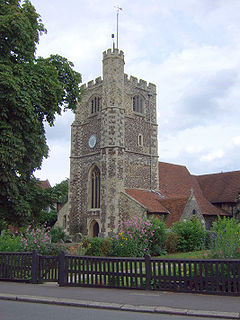
Church of St Mary the Virgin
 Monken Hadley
Monken Hadley shown within Greater LondonOS grid reference TQ245975 London borough Barnet Ceremonial county Greater London Region London Country England Sovereign state United Kingdom Post town BARNET Postcode district EN5 Dialling code 020 Police Metropolitan Fire London Ambulance London EU Parliament London UK Parliament Chipping Barnet London Assembly Barnet and Camden List of places: UK • England • London Monken Hadley is a place in the London Borough of Barnet. An ancient country village north of Barnet, it is now a suburban development situated on the very edge of Greater London 11 miles (18 km) north north-west of Charing Cross, while retaining much of its rural character.
Contents
History
Monken Hadley was originally a civil parish of Middlesex forming part of a small protrusion into Hertfordshire. In 1889, under the Local Government Act 1888, the civil parish was transferred to Hertfordshire. Under the Local Government Act 1894 the parish was split with a Hadley parish becoming part of the Barnet Urban District, while the remaining part of the parish became part of the East Barnet Urban District of Hertfordshire. In 1965, under the London Government Act 1963, its area was transferred to Greater London and combined with that of other districts formerly in Hertfordshire and Middlesex to form the present-day London Borough of Barnet.[1]
Parish church
The parish church of St Mary the Virgin was built in its present form in 1494 (the date being carved in stone over the west door) although a church is believed to have stood on the site for over 800 years. The present building is in the perpendicular style, and includes two side chapels (in transepts) dedicated to St Anne and St Catherine. The building was heavily renovated in Victorian times, and contains large quantities of Victorian woodwork furniture. The parish and church were heavily influenced by tractarianism and the Oxford Movement,[2] and it remains a focus of eucharistic worship within the surrounding district.
The tower of the church, at the west end, contains nine bells which are in good order and regularly rung, eight being hung for change ringing, and the ninth as a sanctus bell.[3] At the top of the tower there is a signal beacon, part of an ancient series of signal beacons. The church markets itself under the title "The Beacon Church", and the beacon has become a symbol of the local area, and forms the badge of the nearby Church of England primary school.
Sport and recreation
Monken Hadley has a King George's Fields open space in memorial to King George V. It is popular with local teams in the summer for playing cricket. The field descends into the Hadley Woods, which make their way into East Barnet Golf course. Hadley Green is a Local Nature Reserve which is a Site of Metropolitan Importance, and traditionally considered the site of a key battle in the Wars of the Roses, the Battle of Barnet in 1471.
Hadley Common has a cricket field, home to a well known cricket club, Monken Hadley CC, which is mentioned in one of the works of Anthony Trollope, who lived in Monken Hadley.
Famous residents
The great adversarial lawyer Sir William Garrow (1760–1840), coiner of the phrase "innocent until proven guilty", was born and brought up in the village.
The writer Kingsley Amis lived for a time in a house near the Common, where his friend the Poet Laureate Cecil Day-Lewis died.
Transport links
Buses
Monken Hadley and Hadley Green are not well-served by bus routes, with most services terminating further south in Barnet. The two Transport for London routes which run nearby are:
- 84 - New Barnet railway station to St Albans
- 399 - Barnet (the Spires) to Hadley Wood railway station - circular service; Monday to Saturday shopping hours only.
Railway
Both fairly nearby are:
- New Barnet railway station - First Capital Connect
- Hadley Wood railway station - First Capital Connect
Tube
Two tube stations are relatively nearby:
- High Barnet (Northern Line), some distance to the south, within walking distance, but accessible via the 84 bus, is the closer of the two.
- Cockfosters (Piccadilly Line), at the other (eastern) end of Monken Hadley, accessible via a longer walk across Monken Hadley Common.
Geographic location
Neighbouring areas 
South Mimms Potters Bar Hadley Wood High Barnet 
Cockfosters  Monken Hadley

Arkley Chipping Barnet New Barnet See also
- Battle of Barnet
- Hadley Green
- King George's Fields
- Monken Hadley Common
References
- ^ Vision of Britain - Monken Hadley parish (historic map)
- ^ See the British History Online website.
- ^ See the church website for details.
External links
Categories:- Districts of Barnet
- Districts of London


Wikimedia Foundation. 2010.