- Mamucium
-
Mamucium 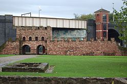
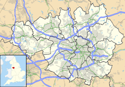
 Location within Greater Manchester
General information Architectural style Roman fort Location Manchester, Greater Manchester, England Coordinates 53°28′33″N 2°15′03″W / 53.475962°N 2.250891°W Completed 79 Mamucium, also known as Mancunium, was a fort in the Roman province of Britannia.[1] The remains of the fort are protected as a Scheduled Ancient Monument, and are located within the Castlefield area of the City of Manchester, in North West England (grid reference SJ833977).[2] Founded c. AD 79, Mamucium was garrisoned by a cohort of auxiliary soldiers and guarded the road running from Chester to York. A vicus, or civilian settlement made up of traders and the families of the soldiers, grew outside the fort and was an area of industrial activity.
The site lay in ruins until the Industrial Revolution. During this period Manchester expanded and the fort was levelled to make way for new developments. It was damaged by the construction of the Rochdale Canal and the Great Northern Railway. The site is now part of the regenerated area of warehousing alongside the Rochdale Canal, part of the Castlefield Urban Heritage Park. Reconstructed remains of the fort's gatehouse, granaries, and some buildings from the vicus are on display to the public.
Contents
Location
When the Roman fort in Castlefield was built, it was located on a naturally defensible sandstone bluff, guarding a nearby crossing over the River Medlock.[3] The fort was situated near a junction between at least two Roman roads. It guarded the road between the legionary fortresses of Deva Victrix (Chester) and Eboracum (York) running east to west, as well as the road between Manchester and Bremetennacum (Ribchester) to the north.[4] In addition, Mamucium may also have overlooked a lesser road running north west to Coccium (Wigan).[5] The fort was one of a chain of fortifications along the Eboracum to Deva Victrix road, with Castleshaw Roman fort lying 16 miles (26 km) to the east,[6] and Condate (Northwich) 18 miles (29 km) to the west. Stamps on tegulae indicate that Mamucium had administrative links not only with Castleshaw, the nearest fort, but also those at Slack and Ebchester; all the forts probably got the tegulae from the same place in Grimescar Wood near Huddersfield.[7]
The area around the fort changed greatly in the centuries that followed; the remains are now surrounded by mills built during Industrial Revolution and were further damaged by the subsequent urbanisation of Manchester. Castlefield is located on the south west corner of Manchester city centre and the Rochdale Canal cuts through the southern corner of the fort.[5] Deansgate, which has developed into a busy thoroughfare, passes close to the east of the fort and follows the general line of Roman road to Ribchester and Castlefield.[5]
History
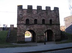 Reconstructed Gateway to Castlefield Roman Fort (Mamucium)
Although there is no evidence of prehistoric settlement, there is evidence of activity in the area. A Neolithic scraper, two Mesolithic flints and a flint flake have been discovered, as well as a shard of late Bronze Age pottery; however these were mostly not found in situ.[8] Although the area was in the territory of the Celtic tribe Brigantes until the Romans annexed the area, it may have been under the control of the Setantii, a sub-tribe of the Brigantes.[9] The fort was built around 79 AD;[10] it was built as part of the fortifications erected under Gnaeus Julius Agricola during his campaigns against the Brigantes after the treaty with the Celtic tribe failed.[11] The name Mamucium is thought to derive from the Celtic meaning "breast shaped hill", referring to the sandstone bluff the fort stood on; this later evolved into the name Manchester.[12][13] The Welsh word for Manchester is "Manceinion" which sounds very similar to Mamucium and has been passed on from the Brythonic language.
Excavations have demonstrated that the fort had three main phases of construction; one in 79 AD, the second in 160 AD, and the third in 200 AD. The first phase of the fort was built from turf and timber.[10] Mamucium was designed to be garrisoned by a cohort, about 500 infantry. They would have been drawn from an auxiliary, the non-citizen soldiers of the Roman army.[14] A civilian settlement called a vicus grew around the fort in the late 1st and early 2nd centuries.[15] Around 90 AD, the ramparts surrounding the fort were strengthened.[10] Manchester and the Roman fort at Slack – which neighboured Castleshaw – superseded the fort at Castleshaw in the 120s.[16] Mamucium was demolished some time around 140 AD.[10] Although the vicus grew rapidly in the early 2nd century,[17] it was abandoned some time between 120 and 160 – broadly coinciding with the demolition of the fort – before it was re-inhabited when the fort was rebuilt.[18]
 Aerial view of the Roman Fort, Castlefield
There is a possible temple to Mithras associated with the civilian settlement,[14] in modern day Hulme.[19] An altar dedicated to "Fortune the Preserver" was found, probably dating to the early 3rd century.[14] In 2008 an altar dating from the late 1st century was discovered near the Roman settlement. It was dedicated to two minor Germanic gods and described as being in "fantastic" condition.[20] The County Archaeologist said
"It's the first Roman stone inscription to be found in Manchester for 150 years and records only the second known Roman from Manchester ... The preservation of the stone is remarkable. On top of the stone is a shallow bowl which was used for offerings of wine or blood or perhaps to burn incense."—Norman Redhead[21]As well as Pagan worship, there is also evidence of early Christian worship. In the 1970s a 2nd century "word square" was discovered with an anagram of PATER NOSTER.[22] There has been discussion by academics whether the "word square", which is carved on a piece of amphora, is actually a Christian artefact, if so, it is one of the earliest examples of Christianity in Britain.[23]
The second phase was built around 160 AD. Although it was again of turf and timber construction, it was larger than the previous fort, measuring 2 hectares (4.9 acres) to accommodate extra granaries (horrea).[24] Around 200 AD, the gatehouses of the fort were rebuilt in stone and the walls surrounding the fort were given a stone facing.[24] The concentration of furnaces in sheds in part of the vicus associated with the fort has been described as an "industrial estate",[25] which would have been the first in Manchester. Mamucium was included in the Antonine Itinerary, a 3rd century register of roads throughout the Roman Empire.[26] This and inscriptions on and repairs to buildings indicate that Mamucium was still in use in the first half of the 3rd century.[27] The vicus may have been abandoned by the mid 3rd century; this is supported by the excavated remains of some buildings while were demolished and the materials robbed for use elsewhere.[18] Evidence from coins indicates that although the civilian settlement associated with the fort had declined by the mid 3rd century, a small garrison may have remained at Mamucium into the late 3rd century and early 4th century.[18]
Post-Roman
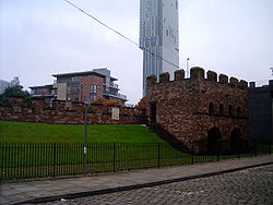 The ruins of the ancient fort with the modern Beetham Tower, Manchester behind
During the medieval period, the area was used for agricultural purposes.[18] After lying derelict for centuries, the ruins were commented on by antiquarians John Leland in the 16th century, William Camden in the late 16th and early 17th centuries, and William Stukeley[5] and the Manchester historian, John Whitaker in the 18th century. In the early 18th century, John Horsley said:
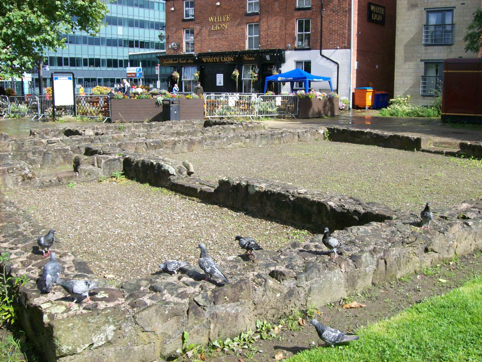
It [the fort] is about a quarter of a mile out of the town, being south or south-west from it. The station now goes by the name of Giant's Castle or Tarquin's Castle, and the field in which it stands is called Castle Field ... the ramparts are still very conspicuous.—John Horsley, Britannia Romana[28] Foundation ruins of the fort in Castlefield
The name "Tarquin's Castle" refers to the legend that the fort had been occupied by a giant named Tarquin.[28]
Whitaker described what remained of the fort in 1773:
The eastern side, like the Western, is hundred and forty [yards] in length, and for eighty yards from the northern termination, the nearly perpendicular rampart carries a crest of more than two [yards] in height. It is then lowered to form the great entrance, the Porta Pretoria of the camp: the earth there running in a ridge, and mounting up to the top of the bank, about ten in breadth. Then, rising gradually as the wall falls away, it carries an height of more than three for as many as the south-eastern angle. And the whole of this wall, bears a broken line of thorns above, shews the mortar peeping here and there under the coat of turf, and near the south-eastern corner has a large buttress of earth continued several yards along it. The southern side, like the Northern, is hundred and seventy five [yards] in length; and the rampart sinking immediately from its elevation at the eastern end, successively declines, till, about fifty yards off, it is reduced to the inconsiderable height of less than one [yard]. And about seventeen yards further, there appears to have been a second gateway, the ground rising up to the crest of the bank of a four or five at the point ...On the south side was particularly requisite ... in order to afford a passage to the river; but about fifty three yards beyond the gates, the ground betwixt both falling away briskly to the west, the rampart, which continues in a right line along the ridge, necessarily rises till it has a sharp slope of twenty yards in length at the southwestern angle. And all this side of the wall, which was from the beginning probably not much higher than it is at present, as it was sufficiently secured by the river and its banks, before it appears crested at first with a hedge of thorns, a young oak rising from the ridge and rearing its head considerably over the rest, and runs afterwards in a smooth line near the level for several yards with the ground about it, and just perceptible to the eye, in a rounded eminence of turf
As to the south-western point of the camp, the ground slopes away on the west towards the south, as well as on the south towards the West. On the third side still runs from it nearly as at first , having an even crest about seven feet in height, an even slope of turf for its whole extent, and the wall in all its original condition below. About a hundred yards beyond the angle was the Porta Decumana of the station, the ground visibly rising up the ascent of the bank in a large shelve of gravel, and running in a slight but perceivable ridge from it. And beyond a level of forty five yards, that still stretches on for the whole length of the side, it was bounded by the western boundary of the British city, the sharp slope of fifty to the morass below it. On the northern and remaining side are several chasms in the original course of the ramparts. And in one of them about a hundred and seventy five yards from its commencement, was another gateway, opening into the station directly from the road to Ribchester. The rest of the wall still rises above five and four feet in height, planted all the way with thorns above, and exhibiting a curious view of the rampart below. Various parts of it have been fleeced of their facing a turf and stone, and now show the inner structure of the whole, presenting to the eye the undressed stone of the quarry, the angular pieces of rock, and the round boulders of the river, all bedded in the mortar, and compacted into one. And the white and brown patches of mortar and stone on a general view of the wall stands strikingly contrasted with the green turf that entirely conceals the level line, and with the green moss that half reveals the projecting points of the rampart. The great foss of the British city, the Romans preserved along their northern side for more than thirty yards along the eastern end of it, and for the whole beyond the Western. And as the present appearances of the ground intimate, they closed the eastern point of it with a high bank, which was raised upon one part of the ditch and sloped away into the other.—John Whitaker, History of Manchester vol I (1773 edition)[29]Mamucium was levelled as Manchester expanded during the Industrial Revolution. The construction of the Rochdale Canal through the south western corner of the fort in the late 18th and early 19th centuries, and the building of viaducts for the Great Northern Railway over the site in the late 19th century, damaged the remains and even destroyed some of the southern half of the fort.[5] When the railway viaducts were built, Charles Roeder documented the remains that were uncovered in the process, including parts of the vicus.[5]
The first archaeological investigation of Mamucium was in 1906. Francis Bruton, who would later work on the Roman fort at Castleshaw, excavated the fort's western defences.[10] A series of small scale excavations were undertaken intermittently between 1912 and 1967, generally exploring the northern defences of the fort.[10][30] In the mid-20th century, historian A. J. P. Taylor called the surviving stretch of Roman wall "the least interesting Roman remains in Britain".[31] The first excavation of the vicus was carried out in the 1970s under Professor Barri Jones.[10] In 1982 the fort, along with the rest of the Castlefield area, became the United Kingdom's first Urban Heritage Park,[32][33] and partial reconstructions of the forts walls, including the ramparts and gateways, were opened in 1984.[14] In 2001–2005 the University of Manchester Archaeological Unit carried out excavations in the vicus to further investigate the site before the area underwent any more regeneration or reconstruction.[3] The archaeological investigation of Mamucium Roman fort and its associated civilian settlement has, so far, provided approximately 10,000 artefacts.[8]
Layout
The fort measured 160 metres (175 yd) by 130 metres (140 yd) and was surrounded by a double ditch and wooden rampart. Around AD 200 the wooden rampart was replaced by stone ramparts,[34] measuring between 2.1 metres (7 ft) and 2.7 metres (9 ft) thick.[19] The vicus associated with Mamucium surrounded the site on the west, north, and east sides, with the majority lying to the north. The vicus covered about 26 hectares (64 acres) and the fort about 2 hectares (4.9 acres).[5] Buildings within the vicus would have generally been one storey, timber framed, and of wattle and daub construction.[34] There may have been a cemetery to the south east of the fort.[19]
See also
References
- ^ Rivet, A L F; Smith, Colin (1979). The Place-Names of Roman Britain. London: B T Batsford.
- ^ "Mamucium". Pastscape.org.uk. http://www.pastscape.org.uk/hob.aspx?hob_id=76731. Retrieved on 29 December 2007.
- ^ a b Gregory (2007), p. 1.
- ^ Gregory (2007), pp. 1–2.
- ^ a b c d e f g Gregory (2007), p. 2.
- ^ Walker (1999), p. 15.
- ^ Walker (1999), p. 78.
- ^ a b Gregory (2007), p. 181.
- ^ Kidd (1996), p. 12.
- ^ a b c d e f g Gregory (2007), p. 3.
- ^ Mason (2001), pp. 41–42.
- ^ Mills, A.D. (2003). A Dictionary of British Place-Names. Oxford: Oxford University Press. ISBN 0-19-852758-6. http://www.oxfordreference.com/pages/Subjects_and_Titles__2B_05.
- ^ Hylton (2003), p. 6.
- ^ a b c d Norman Redhead (20 April 2008). "A guide to Mamucium". BBC Online. http://www.bbc.co.uk/manchester/content/articles/2008/04/10/100408_roman_manchester_feature.shtml. Retrieved on 20 July 2008.
- ^ Gregory (2007), pp. 22, 156.
- ^ Nevell and Redhead (2005), p. 59.
- ^ Gregory (2007), p. 183.
- ^ a b c d Gregory (2007), p. 190.
- ^ a b c Hylton (2003), p. 4.
- ^ David Ottewell (10 April 2008). "Roman soldier's gift found". Manchester Evening News. http://www.manchestereveningnews.co.uk/news/s/1044666_roman_soldiers_gift_found. Retrieved on 20 July 2008.
- ^ "Offering up the past". BBC Online. 10 April 2008. http://www.bbc.co.uk/manchester/content/articles/2008/04/10/100408_roman_altar_feature.shtml. Retrieved on 20 July 2008.
- ^ Shotter (2004), p. 129.
- ^ Shotter (2004), pp. 129–130.
- ^ a b Philpott (2006), p. 66.
- ^ Shotter (2004), p. 117.
- ^ Shotter (2004), p. 40.
- ^ Shotter (2004), p. 153.
- ^ a b Hylton (2003), p. 3.
- ^ Fishwick, Henry (1968 (original edition1894)). "IV Roman remains". A History of Lancashire. County History Reprints. Wakefield, Yorkshire: S.R. Publishers Ltd.. p. 22.
- ^ "Mamucium investigation history". Pastscape.org.uk. http://www.pastscape.org.uk/events.aspx?a=0&hob_id=76731. Retrieved on 18 July 2008.
- ^ Nevell (2008), p. 19.
- ^ Woodside et al. (2004), p. 286.
- ^ Manchester City Council. "Manchester firsts". Manchester.gov.uk. http://www.manchester.gov.uk/site/scripts/documents_info.php?documentID=1148. Retrieved 2008-07-15.
- ^ a b Hylton (2003), p. 2.
Bibliography
- Gregory, Richard (ed) (2007). Roman Manchester: The University of Manchester's Excavations within the Vicus 2001–5. Oxford: Oxbow Books. ISBN 978-1-84217-271-1.
- Hylton, Stuart (2003). A History of Manchester. Chichester: Phillimore and co. Ltd. ISBN 1-86077-240-4.
- Kidd, Alan ([1996] 1993). Manchester. Keele: Keele University Press. ISBN 1-85331-028-X.
- Mason, David J.P. (2001). Roman Chester: City of the Eagles. Stroud: Tempus Publishing Ltd. ISBN 0-7524-1922-6.
- Nevell, Mike (2008). Manchester: The Hidden History. The History Press. ISBN 978-0-7524-4704-9.
- Nevell, Mike and Redhead, Norman (eds) (2005). Mellor: Living on the Edge. A Regional Study of an Iron Age and Romano-British Upland Settlement. University of Manchester Archaeological Unit, Greater Manchester Archaeological Unit, and the Mellor Archaeological Trust. ISBN 0-9527813-6-0.
- Philpott, Robert A. (2006). "The Romano-British Period Resource Assessment". Archaeology North West 8: 59–90. ISSN 0962-4201.
- Roeder, Charles (1900). Roman Manchester.
- Shotter, David ([2004] 1993). Romans and Britons in North-West England. Lancaster: Centre for North-West Regional Studies. ISBN 1-86220-152-8.
- Walker, John (ed) (1989). Castleshaw: The Archaeology of a Roman Fortlet. Greater Manchester Archaeological Unit. ISBN 0-946126-08-9.
- Woodside, Arch et al. (2004). Consumer Psychology of Tourism, Hospitality, and Leisure. CABI Publishing. ISBN 0-85199-535-7. http://books.google.com/?id=tqmmiKCK5PcC&pg=PA285&lpg=PA285&dq=%22Urban+Heritage+Park%22.
Categories:- 79 establishments
- History of Manchester
- Roman forts in England
- Visitor attractions in Manchester
- Scheduled Ancient Monuments in Greater Manchester
- Former populated places in England


Wikimedia Foundation. 2010.