- Böblingen (district)
-
Böblingen — District — 
Country  Germany
State Baden-Württemberg Adm. region Stuttgart Capital Böblingen Area – Total 617.86 km2 (238.6 sq mi) Population (31 December 2010)[1] – Total 371,396 – Density 601.1/km2 (1,556.8/sq mi) Time zone CET (UTC+1) – Summer (DST) CEST (UTC+2) Vehicle registration BB Website http://www.landkreis-boeblingen.de Böblingen is a district (Kreis) in the middle of Baden-Württemberg, Germany. Neighboring districts are (from west clockwise) Calw, Enz, Ludwigsburg, (district) Stuttgart, and the districts Esslingen and Tübingen.
Contents
History
The district was created in 1938 as the successor of the Oberamt Böblingen, which dates back to the duchy of Württemberg. In 1973 the majority of the district Leonberg as well as a few municipalities of the district Calw were added to the district, and a few municipalities moved to the district Ludwigsburg.
Geography
A part of the district is located in the Black Forest, other landscapes covered are the Oberes Gäu and the Schönbuch. The highest elevation is the 626 m high Kühlenberg in the municipality Jettingen; the lowest point with 315 m is in the valley of the Glems at the northern boundary of the district.
Coat of arms
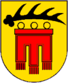
The deer antler in the top of the coat of arms is the symbol of Württemberg. Below is a banner (gonfanon) which is the symbol of the Counts of Tübingen. Towns and municipalities
Towns Municipalities Administrative districts - Aidlingen/Grafenau
- Gärtringen/Ehningen
- Herrenberg
- Holzgerlingen
- Oberes Gäu
- Waldenbuch-Steinenbronn
References
- ^ "Bevölkerung und Erwerbstätigkeit" (in German). Statistisches Landesamt Baden-Württemberg. 31 December 2009. http://www.statistik-bw.de/Veroeffentl/Statistische_Berichte/3126_10001.pdf.
External links
- Official website (German)
 Regions, and urban and rural districts in the state of Baden-Württemberg in Germany
Regions Urban districts Rural districts - Alb-Donau
- Biberach
- Bodensee
- Böblingen
- Breisgau-Hochschwarzwald
- Calw
- Emmendingen
- Enz
- Esslingen
- Freudenstadt
- Göppingen
- Heidenheim
- Heilbronn
- Hohenlohe
- Karlsruhe
- Konstanz
- Lörrach
- Ludwigsburg
- Main-Tauber
- Neckar-Odenwald
- Ortenau
- Ostalbkreis
- Rastatt
- Ravensburg
- Rems-Murr
- Reutlingen
- Rhein-Neckar
- Rottweil
- Schwarzwald-Baar
- Schwäbisch Hall
- Sigmaringen
- Tübingen
- Tuttlingen
- Waldshut
- Zollernalb
Categories:- Districts of Baden-Württemberg
- Stuttgart region

Wikimedia Foundation. 2010.