- Hamstall Ridware
-
"Olive Green" redirects here. For the colour, see olive-green.
Coordinates: 52°46′06″N 1°50′30″W / 52.768275°N 1.841668°W
Hamstall Ridware 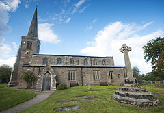
Church of St Michael and All Angels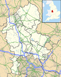
 Hamstall Ridware
Hamstall Ridware shown within StaffordshirePopulation 317 (2001 census)[1] OS grid reference SK107189 District Lichfield Shire county Staffordshire Region West Midlands Country England Sovereign state United Kingdom Post town LICHFIELD Postcode district WS15 Dialling code 01889 Police Staffordshire Fire Staffordshire Ambulance West Midlands EU Parliament West Midlands UK Parliament Lichfield List of places: UK • England • Staffordshire Hamstall Ridware is a village and civil parish[2] in the district of Lichfield in Staffordshire, England. It is in the Trent Valley, and lies close to the villages of Hill Ridware, Mavesyn Ridware and Pipe Ridware. It is eight miles north of the city of Lichfield, and four miles east of Rugeley.
The hamlet of Olive Green lies to the east of the village at grid reference SK116187.
The village name has been adopted as the stage name of half of UK-based downtempo band Sundae Club.
References
- ^ Neighbourhood Statistics - 2001 census
- ^ "Names and codes for Administrative Geography". Office for National Statistics. 31 December 2008. http://www.ons.gov.uk/about-statistics/geography/products/geog-products-area/names-codes/administrative/index.html. Retrieved 15 September 2009.
External links
Lichfield District Council Lichfield District CouncilCivil parishes Alrewas • Armitage with Handsacre • Burntwood • Clifton Campville • Colton • Curborough and Elmhurst • Drayton Bassett • Edingale • Elford • Farewell and Chorley • Fazeley • Fisherwick • Fradley • Hammerwich • Hamstall Ridware • Harlaston • Hints • Kings Bromley • Lichfield • Longdon • Mavesyn Ridware • Shenstone • Streethay • Swinfen and Packington • Thorpe Constantine • Wall • Weeford • Whittington • Wigginton and HopwasCategories:- Villages in Staffordshire
- Civil parishes in Staffordshire
- Lichfield
- Staffordshire geography stubs


Wikimedia Foundation. 2010.