- Queen Maud Land
-
Queen Maud Land Dronning Maud Land
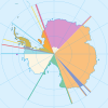
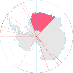 Location of Queen Maud Land (dark pink)
on Antarctica (grey)
Government Dependent territory - Monarch of Norway Harald V - Administration Polar Affairs Department Norwegian dependency - Annexed 14 January 1939 - Dependency 21 June 1957 - Antarctic Treaty System 23 June 1961 Area - Total 2,700,000 km2
1,042,476 sq miQueen Maud Land (Norwegian: Dronning Maud Land)[note 1] is a c. 2.7 million-square-kilometre (1 million sq mi)[4] region of Antarctica claimed as a dependent territory[5] by Norway. The territory lies between 20° west and 45° east, between the British Antarctic Territory to the west and the Australian Antarctic Territory to the east. The latitudinal limits of the territory are not officially defined.[6] Positioned in East Antarctica, the territory comprises one-sixth of the total area of Antarctica.[2] The claim is named for Maud (1869–1938), queen consort of King Haakon VII of Norway.
Norwegian Hjalmar Riiser-Larsen was the first person to set foot in the territory in 1930. On 14 January 1939, the territory was claimed by Norway. From 1939 until 1945, Germany claimed New Swabia,[7] which consisted of part of Queen Maud Land. On 23 June 1961, Queen Maud Land became part of the Antarctic Treaty System, making it a demilitarised zone. It is one of two Antarctic claims made by Norway, the other being Peter I Island. They are administrated by the Polar Affairs Department of the Norwegian Ministry of Justice and the Police in Oslo.
Most of the territory is covered by the Antarctic ice sheet, and a tall ice wall stretches throughout its coast. In some areas further within the ice sheet, mountain ranges breach through the ice, allowing for birds to breed and the growth of a limited flora. The region is divided into the Princess Martha Coast, Princess Astrid Coast, Princess Ragnhild Coast, Prince Harald Coast and Prince Olav Coast. The waters off the coast are called the King Haakon VII Sea.
There is no permanent population, although there are twelve active research stations housing a maximum average of 40 scientists, the numbers fluctuating depending on the season. Six are occupied year-round, while the remainder are seasonal summer stations. The main aerodromes for intercontinental flights, corresponding with Cape Town, South Africa, are Troll Airfield, near the Norwegian Troll research station, and a runway at the Russian Novolazarevskaya Station.[8]
Contents
Geography
Regions and boundaries Region[2] Western
border[9]Eastern
border[9]Princess Martha Coast 20°00'W 05°00'E Princess Astrid Coast 05°00'E 20°00'E Princess Ragnhild Coast 20°00'E 34°00'E Prince Harald Coast 34°00'E 40°00'E Prince Olav Coast 40°00'E 44°38'E Queen Maud Land 20°00'W 44°38'E Queen Maud Land extends from the boundary with Coats Land in the west to the boundary with Enderby Land in the east, and is divided into the Princess Martha Coast, Princess Astrid Coast, Princess Ragnhild Coast, Prince Harald Coast and Prince Olav Coast.[10] The territory is estimated to cover around 2,700,000 square kilometres (1,000,000 sq mi).[4] It is not officially defined where the limits of the claim are in the south and in the sea in the north.[6][note 2] The sea that extends off the coast between the longitudal limits of Queen Maud Land is generally called King Haakon VII Sea.[13][note 3]
 Edge of the Ekstrom Ice Shelf, part of the Queen Maud Land ice shelf.

There is no ice-free land at the coast; the coast consists of a 20-to-30-metre-high (66 to 98 ft) wall of ice throughout almost the entire territory.[14][15][16] It is thus only possible to disembark from a ship in a few places.[16] Some 150 to 200 kilometres (93 to 120 mi) from the coast, rocky peaks pierce the ice cap, itself at a mean height of around 2,000 metres (6,600 ft) above sea level, with the highest point at Jøkulkyrkja (3,148 metres or 10,328 feet) in the Mühlig-Hofmann Mountains.[14][15] The other major mountain ranges are the Heimefront Range, Orvin Mountains, Wohlthat Mountains and Sør Rondane Mountains.[2]
Geologically, the ground of Queen Maud Land is dominated by precambrian gneiss, formed c. 1–1.2 Ga, before the creation of the supercontinent Gondwana. The mountains consist mostly of crystalline and granitic rocks, formed c. 500–600 Ma in the Pan-African orogeny during the assembly of Gondwana.[17] In the farthest western parts of the territory, there are younger sedimentary and volcanic rocks. Research on the thickness of the ice has revealed that without the ice, the coast would be similar to those of Norway and Greenland, with deep fjords and islands.[14]
History
Early activity
Queen Maud Land was the first part of Antarctica to be sighted, on 27 January 1820 by Fabian von Bellingshausen. It was however among the last to be explored, as it required aircraft in combination with ships to undertake systematic exploration.[2] Early Norwegian research activities in Antarctica rested entirely on whaling and sealing expeditions funded by ship owners, particularly by Christen Christensen and his son Lars. The first two Norwegian expeditions were carried out by sealing ships in 1892–93 and 1893–94. While they were primarily sent for exploring, sealing, and whaling possibilities, they also performed scientific research.[18] Further Norwegian expeditions were mounted into the first decades of the 20th century.[19]
The Antarctic Plateau was claimed for Norway by Roald Amundsen as the King Haakon VII Plateau when his expedition was the first to reach South Pole on 14 December 1911. It was mapped as a circular territory comprising the plateau around the South Pole, including all the land below 85°S. However, roughly the same area had been claimed by the British as the King Edward VII Plateau, which rejected the Norwegian claim. Amundsen's claim has never been officially claimed by the Norwegian government.[11][12][20]
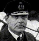 Hjalmar Riiser-Larsen, aviator and polar explorer who explored much of Queen Maud Land.
The name Queen Maud Land was initially applied in January 1930 to the land between 37°E and 49°30'E discovered by Hjalmar Riiser-Larsen and Finn Lützow-Holm during Lars Christensen's Maud.[15] The territory was explored further during the Norvegia expedition of 1930–31.[14] During this whaling season, a total of 265 whaling ships, mostly Norwegian, worked off the coast of Queen Maud Land.[1] In the same season, Riiser-Larsen discovered the Prince Olav Coast, Princess Martha Coast and Princess Ragnhild Coast from the air. Captain H. Halvorsen of the whaler Sevilla discovered the Princess Astrid Coast independently at the same time. Six years later, during Christensen's expedition of 1936–37, Viggo Widerøe flew over and discovered the Prince Harald Coast.[2] Negotiations with the British government in 1938 resulted in the western border of Queen Maud Land being set at 20°W.[14]
Norway's claim was disputed by Germany,[7] which in 1938 dispatched the German Antarctic Expedition, led by Alfred Ritscher, to fly over as much of it as possible.[2][14] The ship Schwabenland reached the pack ice off Antarctica on 19 January 1939.[21] During the expedition, an area of about 350,000 square kilometres (140,000 sq mi) was photographed from the air by Ritscher,[22] who dropped darts inscribed with swastikas every 26 kilometres (16 mi). Germany eventually attempted to claim the territory surveyed by Ritscher under the name New Swabia,[2] but lost any claim to the land following its defeat in the Second World War.[7][note 4]
"That part of the mainland coast in the Antarctic extending from the limits of the Falkland Islands Dependencies in the west (the boundary of Coats Land) to the limits of the Australian Antarctic Territory in the east (45° east long.), with the land lying within this coast and the environing sea, shall be brought under Norwegian sovereignty."
Norwegian royal resolution, 14 January 1939.[23]On 14 January 1939 (five days prior to the German arrival), Queen Maud Land was annexed by Norway,[15] after a royal decree announced that the land bordering the Falkland Islands Dependencies in the west and the Australian Antarctic Dependency in the east was to be brought under Norwegian sovereignty.[14] The primary basis for the annexation was the Norwegian explorations, and to secure the Norwegian whaling industry's access to the region.[15][24] Scientific operations were also a basis, with Norwegian contributions to international polar science extending back to the late 19th century.[15] Norway was in addition forced to contend with competing claims made by the United Kingdom and other countries in the years prior to the Norwegian claim, including the new threat of German claims in Queen Maud Land.[24] The Norwegian claim was sometimes referred to as the "Bouvet sector", drawing from the previously annexed Bouvet Island.[7] In 1946–47, vast areas of Queen Maud Land were photographed during the expedition of Richard Evelyn Byrd. In 1948, Norway and the United Kingdom agreed to limit Queen Maud Land to from 20°W to 45°E, and that the Bruce Coast and Coats Land were to be incorporated into Norwegian territory.[14]
Later developments
The Norwegian–British–Swedish Antarctic Expedition of 1949–52 was the first international scientific expedition in Antarctica. The expedition established its winter quarters at a base called Maudheim at 71°S, 11°W, and mapped much of western Queen Maud Land.[25][26] During the International Geophysical Year in 1957–58, year-round stations was established in Queen Maud Land by Norway, the Soviet Union, Belgium and Japan. The Norwegian expedition continued with topographical mapping, while the others started geophysical and geological research. Norway's Norway Station was lent to South Africa following the withdrawal of the Norwegian expedition in 1960. South Africa later built the SANAE station, near the now-defunct Norway Station. The Soviet Union, and later Russia, has maintained continual operations, although it moved from Lazarev Station to Novolazarevskaya Station. Japan has been based at its Showa Station since 1957, except for a hiatus of a few years. Belgium closed its Roi Baudouin station in 1961, though it mounted limited operations in cooperation with the Netherlands in 1964–66. The United States established the temporary Plateau Station in 1966.[14]
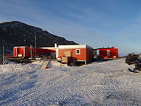 Norway's main research station, Troll, in Queen Maud Land.
In 1948, the newly created Norwegian Polar Institute was assigned the administration of Norwegian territories in the Arctic and Antarctic, including Queen Maud Land.[19] Norway sent two major expeditions to the territory in the 1940s and 1950s, but its efforts declined after that.[15] On 21 June 1957, Queen Maud Land became subject to Norwegian sovereignty as a dependency (biland),[5] and the Antarctic Treaty officially went into force on 23 June 1961.[27] Norwegian activity during the 1960s was limited to some minor co-expeditions with the United States, until it gradually picked up again following a larger expedition to western Queen Maud Land and the eastern Weddell Sea by the Norwegian Polar Institute in 1976–77.[14][15]
Founded in 1978,[28] the Polar Affairs Department of the Norwegian Ministry of Justice and the Police, headquartered in Oslo, has been assigned the administration of the Norwegian polar areas including Queen Maud Land.[29] Since 1979, the Norwegian Polar Institute has been a directorate under the Ministry of the Environment.[30]
In 1992, an expedition by Ivar Tollefsen made the first ascents of several mountains, including the tallest, Jøkulkyrkja.[14] Norway established the summer station Troll in 1989–90.[14][15] In 2003, Environmental Minister Børge Brende was the first Norwegian minister to visit Queen Maud Land, and he soon allocated funds to expand the Troll station.[31] Troll was improved to a year-round station in 2005[14][15] as part of the anniversary of Norway's 100 years of independence.[31] Among the guests were Foreign Minister Jan Petersen and Environmental Minister Knut Arild Hareide,[31] and Troll was officially opened by Queen Sonja of Norway, the first queen to ever visit Antarctica.[32][8] In 2008, Jens Stoltenberg, accompanied by 40 officials, scientist and reporters, visited Queen Maud Land as the first Norwegian prime minister to do so. He personally named three mountains around the Troll station where he was based, although he chose to sleep outdoors in a tent, rather than in a bed inside. He stated as the purpose of the visit to claim Norway's belonging in Antarctica, as well as to learn more about the climate research at Troll, which he said was key to better understand the global climate change.[32][8]
Legal status
 The location of Norway (highlighted, white) and Queen Maud Land (scattered, red).
Like all other territorial claims in Antarctica, the Norwegian claim of Queen Maud Land (and Peter I Island) is subject to the Antarctic Treaty System. The treaty makes clear that Antarctica can only be used for peaceful purposes, and assures the freedom of scientific activity. It promotes international scientific cooperation, and bans any nuclear activity. Although territorial claims are not invalidated by the treaty, all claims are effectively suspended as long as the treaty is in force.[30][33] Norway, Australia, France, New Zealand and the United Kingdom have all mutually recognised each other's claims in Antarctica.[34]
Norwegian administration of Queen Maud Land is controlled by the Polar Affairs Department of the Norwegian Ministry of Justice and the Police, located in Oslo.[35] The annexation of the territory is regulated by the Dependency Act of 24 March 1933, with Queen Maud Land added on 21 June 1957. It establishes that Norwegian criminal law, private law and procedural law applies to the territory, in addition to other laws that explicitly state they are valid in the territory. Furthermore, it establishes that all the land belongs to the state, and prohibits both nuclear explosions and the storage of nuclear waste.[36]
Since 5 May 1995, Norwegian law has required all Norwegian activity in Antarctica to follow international environmental law for Antarctica. Norwegian citizens who plan activities in Queen Maud Land must therefore report to the Norwegian Polar Institute, which may prohibit any nonconforming activity. Those who visit Queen Maud Land must follow laws regarding protection of nature, treatment of waste, pollution and insurance for search and rescue operations.[37]
Fauna and flora
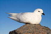 Snow petrels are one of the birds found in Queen Maud Land.
There are three types of birds around Troll: the Antarctic petrel, the snow petrel and the only raptor in Queen Maud Land, the South Polar skua. The Antarctic petrel lives on the sea ice for most of the year, with the exception of its breeding season (in Antarctica, from November to February), when it moves to the inland mountains and nunataks.[38] The 3.9-square-kilometre (1.5 sq mi) area of ice-free cliffs in Princess Astrid Coast called Svarthamaren Mountain hosts Antarctica's largest known inland colony of breeding seabirds, almost 1 million (250,000 pairs) Antarctic petrels.[15][38] Many snow petrels and South Polar skuas also breed in this area. Snow petrels are generally spread out in smaller colonies throughout the mountainous areas of Queen Maud Land. During the breeding season, the South Polar skua feeds exclusively upon the eggs, as well as both young and adult birds, of both petrel species.[38]
The Emperor penguin has some of its breeding places concentrated in Queen Maud Land.[39] All four of the true Antarctic seals, namely the Weddell seal, leopard seal, crabeater seal and Ross seal, can be found in the King Haakon VII Sea off Queen Maud Land.[40][41] The Ross seal is notably found in its greatest numbers in the King Haakon VII Sea.[42]
The nunatak areas have a scarcity of flora, limited to lichen, bryophyte and algae. Flowering plants are not found there. The Norwegian Polar Institute has not registered the occurrence of any threatened or rare plants or animals in Queen Maud Land, the known ones thus existing in healthy populations.[40]
Research stations
Recent research activity
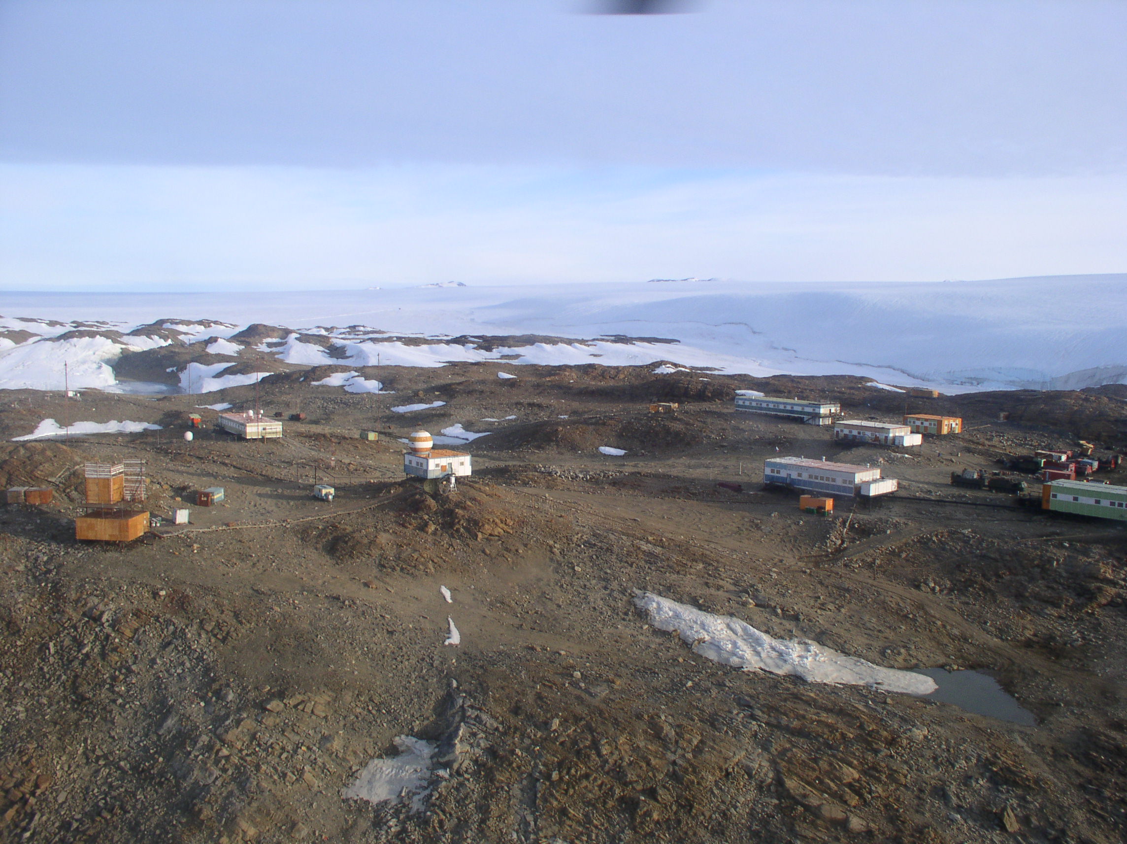
Further information: Research stations in Antarctica. Novolazarevskaya Station.
Research stations in Queen Maud Land are connected by the Dronning Maud Land Air Network Project (DROMLAN), which is a cooperative agreement for transportation between eleven nations with research stations in East Antarctica. Long-range aircraft fly between Cape Town, South Africa and either the Troll Airfield, located at the Troll research station, or the runway at the Novolazarevskaya Station. From these two main airfields, smaller aircraft may fly further to other Antarctic destinations.[8]
Through the Troll Airfield, Norway's Troll station serves as a major hub of the DROMLAN network.[8] Research at Troll include air and atmospheric measurements,[43] monitoring of greenhouse gases and bird colonies, as well as meteorological and climate research.[31] The other Norwegian station, Tor, was established for researching birds at the breeding colony in Svarthamaren Mountain.[38] Activities conducted by Russia's Novolazarevskaya Station include environmental monitoring, geodesy/mapping, geomagnetic and meteorological observations, glaciology, biology, ionospheric/auroral observations, limnology, geology, geophysics and seismology.[44]
 The SANAE IV station.
South Africa's SANAE IV station was finished in 1997, as the successor to three former stations. Research at SANAE IV include invasion biology/ecology, geology, geomorphology and atmospheric sciences. Its facilities include a small hospital and a two-helicopter hangar.[45]
The Swedish Wasa station and the Finnish Aboa station together make up the Nordenskiöld Base, and cooperate in research and logistics. Research carried out includes geodesy/mapping, glaciology, human biology, meteorological observations, geology and geophysics.[46]
 The Kohnen station.
The German Neumayer-Station III, finished in 2009, succeeded two former stations that were buried by snow and ice.[1] It conducts geophysical, meteorological and seismological research, as well as air chemistry measurements and atmospheric ozone monitoring.[47] Germany's other station, Kohnen, was opened as part of a major ice-drilling project.[48]
The Maitri station succeeded the Dakshin Gangotri station in 1989, India's first Antarctic base.[49] Maitri's research focus on geology, and the study of the supercontinent Gondwana, when India and Antarctica belonged to the same landmass. It also includes low-temperature engineering research that is relevant to conditions in the Himalayas.[50]
 Princess Elisabeth Base.
The Showa Station is Japan's main research station in Antarctica. A vast array of research is conducted there, including upper atmosphere physics, meteorology, seismology, gravimetry, geodesy/mapping, oceanography, glaciology, geology, marine and terrestrial biology, and medical research.[51] Japan's other station, Dome Fuji Station was opened as part of a major ice-coring project.[2] It mainly studies climate change, and conducts deep drilling and atmospheric observations.[52]
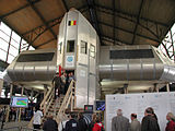
Belgium's Princess Elisabeth Base was established as a project to promote polar sciences, as well as to demonstrate the possibility of building a Zero emission station.[53] Research is conducted by an international team of scientists, studying climatology, glaciology and microbiology.[54]
List of current research stations
The following table lists the currently operational research stations in Queen Maud Land, sorted from westernmost to easternmost. The population figures show the winter average first (if applicable), and the peak (or maximum capacity in the case of the newly opened Princess Elisabeth Base) population last.[55][56]
Detailed list of current research outposts Research station Country Est. Type Pop.
(winter)Pop.
(peak)Coordinates Altitude Wasa (Nordenskiöld Base) Sweden 1989 Seasonal 0 20 73°03′S 13°25′W / 73.05°S 13.417°W 400 metres (1,300 ft) Aboa (Nordenskiöld Base) Finland 1989 Seasonal 0 20 73°03′S 13°25′W / 73.05°S 13.417°W 400 metres (1,300 ft) Neumayer-Station III Germany 1981 Year-round 9 50 70°38′S 08°16′W / 70.633°S 8.267°W 40 metres (130 ft) SANAE IV South Africa 19621 Year-round 10 80 71°40′S 02°50′W / 71.667°S 2.833°W 841 metres (2,759 ft) Kohnen Germany 2001 Seasonal 0 28 75°00′S 00°02′W / 75°S 0.033°W 2,900 metres (9,500 ft) Troll Norway 19902 Year-round 7 40 72°00′S 02°32′E / 72°S 2.533°E 1,300 metres (4,300 ft) Tor Norway 1985 Seasonal 0 4 71°53′S 05°09′E / 71.883°S 5.15°E 1,625 metres (5,331 ft) Maitri India 1989 Year-round 25 65 70°46′S 11°44′E / 70.767°S 11.733°E 130 metres (430 ft) Novolazarevskaya Station Russia 1961 Year-round 30 70 70°46′S 11°52′E / 70.767°S 11.867°E 102 metres (335 ft) Princess Elisabeth Base Belgium 2009 Seasonal 0 20 71°57′S 23°20′E / 71.95°S 23.333°E 1,397 metres (4,583 ft) Showa Station Japan 1957 Year-round 40 110 69°00′S 39°35′E / 69°S 39.583°E 29 metres (95 ft) Dome Fuji Station Japan 1995 Seasonal 0 40 77°19′S 39°42′E / 77.317°S 39.7°E 3,810 metres (12,500 ft) 1 While the original SANAE station was opened in 1962, the current SANAE IV station was opened in 1997, 200 kilometres (120 mi) south of the former stations.
2 The Troll station was in 1990 opened as a seasonal summer-only station, and was opened for year-round operations in 2005.See also
Notes
- ^ The Norwegian name, Dronning Maud Land, is also used by English speakers.[1][2] This derives from a 1974 agreement between Norway and the United Kingdom, in which it was agreed to not translate the place names in each other's respective claims. Informal corresponding agreements is also in effect with Australia, New Zealand and France.[3]
- ^ Norway has been careful to not validate the sector device for demarcating polar territory. This is because it would have compromised Norway's position in the Arctic with regards to the former Soviet Union and present Russia. Norway has thus not permitted its claim to extend to the South Pole and has never legally upheld Roald Amundsen's 1911 claim to the Antarctic Plateau.[11][12]
- ^ Russian cartographers however interpose three marginal seas along the coast, namely the Lazarev Sea, Riiser-Larsen Sea and the Cosmonaut Sea.[13]
- ^ Although some, notably Norwegian writer Bjarne Aagaard and German geographer Ernst Herrmann, have claimed that Germany never actually occupied the territory, it is well documented that Germany issued a decree about the establishment of a German Antarctic Sector called New Swabia after the expedition's return in August 1939.[7]
References
- ^ a b c Rubin, 2008, p. 304.
- ^ a b c d e f g h i j Mills, 2003, p. 540.
- ^ Ørvoll, Oddveig Øien. "Kartlegginga av Antarktis: Internasjonale avtaler" (in Norwegian). Norwegian Polar Institute. http://www.npolar.no/no/antarktis/kartlegginga-antarktis.html. Retrieved 15 July 2011.
- ^ a b "Minifacts about Norway 2011: 2. Geography, climate and environment". Statistics Norway. 2011. http://www.ssb.no/english/subjects/00/minifakta_en/en/main_02.html. Retrieved 21 August 2011.
- ^ a b "Forutsetninger for Antarktistraktaten: Dronning Maud Lands statsrettslige stilling - "utviklingen" frem til 1957" (in Norwegian). Norsk Polarhistorie. http://www.polarhistorie.no/artikler/2009/Dronning%20Maud%20Lands%20statsrettslige%20stilling. Retrieved 15 May 2011.
- ^ a b "Dronning Maud Land". Norwegian Polar Institute. http://www.npolar.no/en/antarctica/dronning-maud-land.html. Retrieved 20 August 2011.
- ^ a b c d e Widerøe, Turi (2008). "Annekteringen av Dronning Maud Land" (in Norwegian). Norsk Polarhistorie. http://www.polarhistorie.no/artikler/2008/annekteringen%20av%20dronning%20maud%20land/print_artikler_view. Retrieved 15 July 2011.
- ^ a b c d e Rubin, 2008, p. 305.
- ^ a b Mills, 2003, pp. 130 and 172.
- ^ "Queen Maud Land". Encyclopædia Britannica. http://www.britannica.com/EBchecked/topic/486862/Queen-Maud-Land. Retrieved 25 April 2011.
- ^ a b Joyner, 1992, p. 47.
- ^ a b Hatherton, Trevor (1965). Antarctica. The New Zealand Antarctic Society. p. 21. http://books.google.com/books?id=20sOAAAAQAAJ&pg=PA21&dq=onepage&q=.
- ^ a b Stonehouse, pp. 155–156.
- ^ a b c d e f g h i j k l m n Gjeldsvik, Tore. "Dronning Maud Land" (in Norwegian). Store norske leksikon. http://www.snl.no/Dronning_Maud_Land. Retrieved 9 May 2011.
- ^ a b c d e f g h i j k "Dronning Maud Land" (in Norwegian). Norwegian Polar Institute. http://www.npolar.no/no/antarktis/dronning-maud-land.html. Retrieved 10 May 2011.
- ^ a b Shirihai, Hadoram; Cox, John (2008). The complete guide to Antarctic wildlife: birds and marine mammals of the Antarctic continent and the Southern Ocean. Princeton University. p. 517. http://books.google.com/books?id=YU8XAQAAIAAJ&q=.
- ^ Elvevold, Synnøve (2005) (in Norwegian). Geologi i Antarktis. Norwegian Polar Institute. http://www.polarhistorie.no/filearchive/Faktaark_NP_012.pdf. Retrieved 18 July 2011.
- ^ Heldal, 2011, p. 10.
- ^ a b Heldal, 2011, p. 11.
- ^ "1911:" (in Norwegian). Norsk Polarhistorie. http://www.polarhistorie.no/hendelser/1209014135.65/tidslinjehendelse_view?geografi=1162838073.78&hovedemne=&underemne=&hovedepoke=&underepoke=&. Retrieved 11 July 2011.
- ^ Murphy, 2002, p. 192.
- ^ Murphy, 2002, p. 204.
- ^ Hince, Bernadette (2000). The Antarctic dictionary: a complete guide to Antarctic English. CSIRO. ISBN 9780957747111. http://books.google.com/books?id=lJd8_owUxFEC&pg=PA242&lpg=PA242&dq=0CDcQ6AEwBTgK#v=onepage&q&f=false.
- ^ a b "Forutsetninger for Antarktistraktaten" (in Norwegian). Norsk Polarhistorie. http://www.polarhistorie.no/artikler/2009/Antarktistraktaten. Retrieved 15 May 2011.
- ^ Molle, Kris (2 December 2010). "Maudheim". Polar Conservation Organisation. http://www.polarconservation.org/education/antarctic-bases/norway-and-antarctica/stations-bases-camps-and-refuges/maudheim. Retrieved 22 July 2011.
- ^ "Maudheim-ekspedisjonen (NBSX)" (in Norwegian). Norsk Polarhistorie. http://www.polarhistorie.no/ekspedisjoner/Maudheim-ekspedisjonen. Retrieved 22 July 2011.
- ^ "Forutsetninger for Antarktistraktaten: Antarktistraktaten" (in Norwegian). Norsk Polarhistorie. http://www.polarhistorie.no/artikler/2009/Antarktistraktaten2. Retrieved 15 May 2011.
- ^ "Polar Affairs Department". Norwegian Social Science Data Services. http://www.nsd.uib.no/polsys/data/en/forvaltning/enhet/13065. Retrieved 12 July 2011.
- ^ "Polar Affairs Department". Norwegian Ministry of Justice and the Police. http://www.regjeringen.no/en/dep/jd/About-the-Ministry-of-Justice-and-the-Po/Organization/Departments/The-Polar-Affairs-Department.html?id=1447. Retrieved 12 July 2011.
- ^ a b Molle, Kris (29 October 2010). "Norway and Antarctica". Polar Conservation Organisation. http://www.polarconservation.org/education/antarctic-bases/norway-and-antarctica/norway-and-antarctica. Retrieved 22 July 2011.
- ^ a b c d Jaklin, G. S. (2005) (in Norwegian). Norge: Året rundt i Antarktis. Norwegian Polar Institute. http://www.polarhistorie.no/filearchive/Faktaark_NP_010.pdf. Retrieved 18 July 2011.
- ^ a b Jenssen, Elin Vinje (22 January 2008). "Stoltenberg named mountains in Antarctica". Norwegian Polar Institute. http://www.npolar.no/en/about-us/news/archive/2008/2008-01-22-stoltenberg-named-mountains-antarctica.html. Retrieved 15 May 2011.
- ^ "Antarktistraktaten" (in Norwegian). Norwegian Polar Institute. http://www.npolar.no/no/antarktis/antarktistraktaten.html. Retrieved 18 July 2011.
- ^ National Research Council (U.S.). Polar Research Board (1986). Antarctic treaty system: an assessment. National Academies Press. p. 370. ISBN 9780309036405. http://books.google.com/books?id=gNxjxfm4cSgC&pg=PP1&pg=PA370#v=onepage&q&f=false.
- ^ "Polar Affairs Department". Norwegian Ministry of the Environment. http://www.regjeringen.no/en/dep/jd/About-the-Ministry-of-Justice-and-the-Po/Organization/Departments/The-Polar-Affairs-Department.html?id=1447. Retrieved 18 July 2011.
- ^ "Lov om Bouvet-øya, Peter I's øy og Dronning Maud Land m.m. (bilandsloven)." (in Norwegian). Lovdata. 13 July 2011. http://www.lovdata.no/all/tl-19300227-003-0.html#1. Retrieved 18 July 2011.
- ^ "Antarktis". Norwegian Ministry of the Environment. http://www.regjeringen.no/nb/dep/md/tema/svalbard_og_polaromradene/antarktis.html?id=279712. Retrieved 19 May 2010.
- ^ a b c d Strøm, Hallvard. "Faktaark: Sjøfuglene i Antarktis" (in Norwegian). Norwegian Polar Institute. http://www.npolar.no/no/tjenester/publikasjoner/faktaark/sjofugler-antarktis.html. Retrieved 11 July 2011.
- ^ Rubin, 2008, p. 120.
- ^ a b "Dronning Maud Land" (in Norwegian). Miljøstatus i Norge. 6 September 2010. http://www.miljostatus.no/Tema/Polaromradene/Antarktis/Dronning-Maud/. Retrieved 15 July 2011.
- ^ Joyner, 1992, p. 26.
- ^ Stone, David (1995). Seals. International Union for Conservation of Nature. p. 19. ISBN 9782831700496. http://books.google.com/books?id=bIGvBCorXLcC&pg=PA19&dq=.
- ^ "Antarktis: Troll får nye krefter". Norwegian Institute for Air Research. Archived from the original on 4 October 2010. http://www.webcitation.org/5tEHjLSg0. Retrieved 4 October 2010.
- ^ Molle, Kris (2 December 2010). "Novolazarevskaya". Polar Conservation Organisation. http://www.polarconservation.org/education/antarctic-bases/russia-and-the-antarctic/stations-bases-camps-and-refuges/novolazarevskaya. Retrieved 21 August 2011.
- ^ Rubin, 2008, pp. 304–305.
- ^ Molle, Kris (2 November 2010). "Aboa". Polar Conservation Organisation. http://www.polarconservation.org/education/antarctic-bases/finland-and-antarctica/stations-bases-camps-and-refuges/aboa. Retrieved 21 August 2011.
- ^ Molle, Kris (2 December 2010). "Neumayer". Polar Conservation Organisation. http://www.polarconservation.org/education/antarctic-bases/germany-and-antarctica/stations-bases-camps-and-refuges/neumayer. Retrieved 21 August 2011.
- ^ Mills, 2003, p. 259.
- ^ Rubin, 2008, p. 306.
- ^ McGonigal, 2009, p. 110.
- ^ "Syowa". Polar Conservation Organisation. 3 November 2010. http://www.polarconservation.org/education/antarctic-bases/japan-and-antarctica/stations-bases-camps-and-refuges/syowa. Retrieved 21 August 2011.
- ^ Molle, Kris (3 November 2010). "Dome Fuji". Polar Conservation Organisation. http://www.polarconservation.org/education/antarctic-bases/japan-and-antarctica/stations-bases-camps-and-refuges/dome-fuji. Retrieved 21 August 2011.
- ^ "Princess Elisabeth Antarctica". Princess Elisabeth Antarctica. http://www.antarcticstation.org/station/. Retrieved 21 August 2011.
- ^ Molle, Kris (2 November 2010). "Princess Elisabeth". Polar Conservation Organisation. http://www.polarconservation.org/education/antarctic-bases/belgium-and-antarctica/stations-bases-camps-and-refuges/princess-elisabeth-base. Retrieved 21 August 2011.
- ^ "Antarctic Facilities". Council of Managers of National Antarctic Programs. 25 March 2009. https://www.comnap.aq/facilities. Retrieved 11 July 2011.
- ^ "Antarctic information". Scientific Committee on Antarctic Research. September 2009. http://www.scar.org/information/. Retrieved 11 July 2011.
Bibliography
- Heldal, Tom (2011). Abstracts and Proceedings of the Geological Society of Norway: Vinterkonferansen 2011. Stavanger: Geological Society of Norway. ISBN 978-82-92394-62-5. http://www.geologi.no/data/f/0/20/40/9_2401_0/Abstracts_WinterConf2011.pdf.
- Joyner, Christopher C. (1992). Antarctica and the law of the sea. Martinus Nijhoff Publishers. ISBN 9780792318231. http://books.google.com/books?id=y6JAr747H60C&pg=PA47&dq=.
- McGonigal, David (2009). Antarctica: Secrets of the Southern Continent. frances lincoln ltd. ISBN 9780711229808. http://books.google.com/books?id=8bFcJgX0lIUC&dq=.</ref>
- Mills, William James (2003). Exploring Polar frontiers: A - L., Volume 1. ABC-CLIO. ISBN 9781576074220. http://books.google.com/books?id=PYdBH4dOOM4C&printsec=frontcover#v=onepage&q&f=false.
- Murphy, David Thomas (2002). German exploration of the polar world: a history, 1870-1940. University of Nebraska. ISBN 9780803232051. http://books.google.com/books?id=gZMvwDzH5SoC&printsec=frontcover#v=onepage&q&f=false.
- Rubin, Jeff (2008). Antarctica. Lonely Planet. ISBN 9781741045499. http://books.google.com/books?id=P9-DG11ncGkC&pg=PA120&dq=onepage&q&f=false.
- Stonehouse, Bernard (2002). Encyclopedia of Antarctica and the southern oceans. John Wiley and Son. ISBN 9780471986652. http://books.google.se/books?id=6uFd1mICC98C&dq.
External links
Antarctic territorial claims Current - Adélie Land
- Argentine Antarctica
- Australian Antarctic Territory
- British Antarctic Territory
- Chilean Antarctica
- Peter I Island
- Ross Dependency
- Queen Maud Land
Proposed Former Integral overseas areas and dependencies of Norway Integral territories Dependent territories Bouvet Island · Peter I Island · Queen Maud Land
Outlying territories of European countries Territories under European sovereignty but closer to or on continents other than Europe (see inclusion criteria for further information) Denmark France Italy Netherlands Norway Portugal Spain United
KingdomAnguilla · Bermuda · British Virgin Islands · Cayman Islands · Falkland Islands · Montserrat · Saint Helena, Ascension and Tristan da Cunha · Turks and Caicos Islands · British Antarctic Territory · British Indian Ocean Territory · Pitcairn Islands · South Georgia and the South Sandwich IslandsAntarctica Main articles - Antarctic
- History
- Geography
- Climate
- Expeditions
- Research stations
- Field camps
- Territorial claims
- Antarctic Treaty System
- Telecommunications
- Demographics
- Economy
- Tourism
- Transport
- Military activity in the Antarctic
Geographic regions - Antarctic Peninsula
- East Antarctica
- West Antarctica
- Extreme points of the Antarctic
- List of Antarctic and subantarctic islands
- Antarctica ecozone
Waterways Famous explorers  Portal:AntarcticaCategories:
- Queen Maud Land
- East Antarctica
- Antarctic territorial claims


Wikimedia Foundation. 2010.