- Markbeech
-
Markbeech is a village in the civil parish of Hever in the Sevenoaks District of Kent, England. The village is located on the northern slopes of the Weald, nine miles (13 km) north-west of Tunbridge Wells.
The church, part of a united benefice with Hever and Four Elms, is dedicated to the Holy Trinity. There is a village hall, a pub - The Kentish Horse, and a thriving cricket club.
External links
Towns and villages in the Sevenoaks district of Kent, England 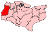 Ash · Badgers Mount · Bough Beech · Brasted · Brasted Chart · Chartwell · Chevening · Chiddingstone · Chiddingstone Causeway · Chiddingstone Hoath · Chipstead · Cowden · Crockenhill · Crockham Hill · Dunton Green · Edenbridge · Eynsford · Farningham · Fawkham · Fawkham Green · Fordcombe · Four Elms · Godden Green · Halstead · Hartley · Hever · Hextable · Hodsoll Street · Horton Kirby · Ide Hill · Kemsing · Knockholt · Leigh · Markbeech · New Ash Green · Otford · Penshurst · Ridley · Riverhead · Seal · Seal Chart · Sevenoaks · Sevenoaks Weald · Shoreham · South Darenth · Sundridge · Swanley · Swanley Village · Toys Hill · Underriver · Well Hill · Westerham · West Kingsdown
List of places in Kent Categories:- Sevenoaks
- Villages in Kent
- Kent geography stubs

Wikimedia Foundation. 2010.