- New Jersey Route 187
-
Route 187
Route information Maintained by South Jersey Transportation Authority Length: 0.40 mi[1] (0.64 km) Major junctions South end:  ACE Conn. in Atlantic City
North end:  Route 87 in Atlantic City
Location Counties: Atlantic Highway system New Jersey State Highway Routes
Interstate and US←  Route 185
I-195  →
→Route 187 is the shortest signed state highway in the state of New Jersey, in the United States. The route is only 0.40-mile (0.64 km) long, shorter than both New Jersey Route 62 and New Jersey Route 185, 0.47 miles (0.76 km) and 0.65 miles (1.05 km) long respectively, running along Brigantine Boulevard in Atlantic City. The route's southern terminus is at the Atlantic City – Brigantine Connector (NJ 446X) off-ramp to U.S. Route 30 and terminates at its parent, New Jersey Route 87 (Huron Boulevard) nearby. Route 187 is not maintained by the New Jersey Department of Transportation, but instead the South Jersey Transportation Authority, which maintains the Brigantine Connector nearby.
Route 187 originates as an alignment of State Highway Route S-4-A, designated in the 1927 renumbering of highways. After Route S-4-A's extension from Ocean County was canceled, Route S-4-A along this alignment became State Highway Route S-56, as a spur of Route 56. Route S-56 became Route 87 in the renumbering, and by the 1980s, Route 87 was realigned off of Brigantine Boulevard and onto Huron Avenue. The route was later renumbered Route 187. During construction of the Brigantine Connector in 2001, Route 187 was severed from its former southern terminus at U.S. Route 30 and truncated back to its current alignment.
Contents
Route description
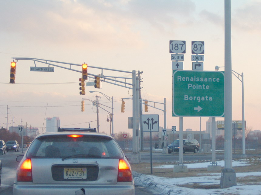
 Route 187 southbound from just exiting Route 87 southbound
Route 187 begins at an intersection with an off-ramp for U.S. Route 30 from the Atlantic City–Brigantine Connector (NJ 446X) in Atlantic City. The highway heads northward along Brigantine Boulevard, passing by fields along the Connector and to the west of local townhouses. Intersecting with North Carolina Avenue, a dead-end connector near MGM Casino and Resort, Route 187 continues along Brigantine Boulevard through Atlantic City, passing a large baseball field before intersecting with West Maryland Avenue.[2] A short distance after West Maryland Avenue, Route 187 terminates at an intersection with New Jersey Route 87 (Huron Avenue)[1] while Brigantine Boulevard continues a short distance, merging into the Connector soon after.[2]
History
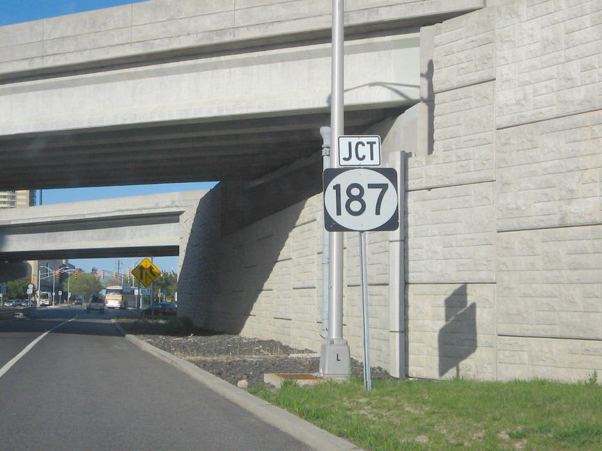
 Junction signage for Route 187 after just exiting Route 87 northbound
Route 187 originates as a former alignment of State Highway Route S-4-A dating back to the 1927 state highway renumbering. State Highway Route S-4-A was proposed to be an extension along Great Bay Boulevard from Tuckerton to Atlantic City.[3] Route S-4-A was never constructed across the waterway and in 1945, the route was changed from State Highway Route S-4-A to Route S-56.[4] Route S-56 remained intact until the 1953 state highway renumbering, when it was renumbered to Route 87.[5] Route 87 ran along Brigantine Boulevard until the 1970s, when the route was realigned onto Huron Avenue.[6] The route later became Route 187, running from U.S. Route 30 to Route 87. However, the southern terminus was truncated when the Atlantic City–Brigantine Connector was constructed in 2001,[7] which severed Route 187 from Route 30. Route 187 now ends at the off-ramp to U.S. Route 30.[1]
Major intersections
The entire route is in Atlantic City, Atlantic County.
Mile[1] Destinations Notes 0.00 ACE Conn.Connections to  US 30
US 300.40 Route 87 (Huron Avenue)Connections to the Atlantic City–Brigantine Connector 1.000 mi = 1.609 km; 1.000 km = 0.621 mi See also
 U.S. Roads portal
 New Jersey portal
References
- ^ a b c d "Route 187 Straight Line Diagram". New Jersey Department of Transportation. 2009. http://www.state.nj.us/transportation/refdata/sldiag/00000187__-.pdf. Retrieved October 19, 2009.
- ^ a b Bing Maps (2009). Overview map of Route 187 (Map). Cartography by NAVTEQ Inc.. http://www.maps.bing.com/maps/default.aspx?v=2&FORM=LMLTCP&cp=qjw7878sxn65&style=b&lvl=1&tilt=-90&dir=0&alt=-1000&phx=0&phy=0&phscl=1&scene=14913839&rtp=pos.39.3722044676542_-74.4323080033064_near%20Brigantine%20Blvd%2C%20Atlantic%20City%2C%20New%20Jersey%2008401%2C%20United%20States__~pos.39.3777103722095_-74.4306148588657_near%20Brigantine%20Blvd%2C%20Atlantic%20City%2C%20New%20Jersey%2008401%2C%20United%20States__&rtop=0~0~0&encType=1. Retrieved October 19, 2009.
- ^ "319". ROUTE No. S-4-A. EXTENDING FROM ROUTE NO. 4 NEAR TUCKERTON TO LITTLE BEACH.. Trenton, New Jersey: New Jersey State Legislature. 1927.
- ^ "11". ROUTE NO. 56 S. Beginning at the intersection of the Absecon boulevard and the Brigantine boulevard in the city of Atlantic City, New Jersey; thence, in and along said Brigantine boulevard across Beach thoroughfare or Inlet channel to the city of Brigantine.. Trenton, New Jersey: New Jersey State Legislature. 1945.
- ^ 1953 renumbering, New Jersey Department of Highways, http://en.wikisource.org/wiki/1953_New_Jersey_state_highway_renumbering, retrieved 2009-07-31
- ^ Rand McNally (1982). Business Atlas (Map). Cartography by Rand McNally.
- ^ Patterson, Iver (July 28, 2001). "Atlantic City Car Tunnel Opens Briefly, for Pedestrians". The New York Times. http://query.nytimes.com/gst/fullpage.html?res=9A0DEEDC133DF93BA15754C0A9679C8B63. Retrieved 2007-12-30.
External links
Categories:- State highways in New Jersey
- Atlantic City, New Jersey
- Transportation in Atlantic County, New Jersey

Wikimedia Foundation. 2010.