- Maryland Route 384
-
Maryland Route 384
Colesville Road 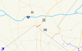
Maryland Route 384 highlighted in redRoute information Maintained by MDSHA Length: 0.53 mi[1] (0.85 km) Major junctions West end:  MD 390 in Silver Spring
 MD 410 in Silver Spring
East end: 
 US 29 / MD 97 in Silver Spring
Highway system Maryland highway system
Interstate • US • State • Minor • Former • Turnpikes←  MD 383
MD 387  →
→Maryland Route 384 (MD 384) is a state highway in the U.S. state of Maryland. The state highway runs 0.53 mi (0.85 km) from MD 390 east to U.S. Route 29 (US 29) and MD 97 within Silver Spring. MD 384 is the southernmost portion of Colesville Road, a major commuting route and one of the two main streets (along with Georgia Avenue) within downtown Silver Spring, the commercial hub of southeastern Montgomery County. The state highway also provides access to the Silver Spring station of the Washington Metro, which serves as a transit hub for commuter rail and bus service for the surrounding area.
Contents
Route description
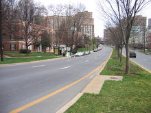 MD 384 looking north from its southern terminus at MD 390 in Silver Spring
MD 384 begins at MD 390 (16th Street) just north of the boundary between Maryland and the District of Columbia.[2] Traffic on southbound MD 390 must travel around the Blair Portal traffic circle immediately to the south to access MD 384 from northbound MD 390. MD 384 heads east as a six-lane divided highway between apartment complexes.[1][2] The development becomes a mix of commercial retail and office buildings at the intersection with MD 410 (East–West Highway). The state highway passes the Silver Spring offices of the National Oceanic and Atmospheric Administration and the headquarters of the National Weather Service on the northeast corner of the MD 410 junction.[2] MD 384 continues northeast, passing under a railroad overpass that carries CSX's Metropolitan Subdivision and the Red Line (Washington Metro) of the Washington Metro.[1][2] Pedestrian access to the Silver Spring Metro Station is provided on both sides of the highway. Vehicular access to the transit center—which is also a stop on MARC's Brunswick Line and a hub for Metrobus, Ride On, and MTA Maryland Commuter Bus service—is provided at the next intersection with Wayne Avenue and Second Street. Shortly after passing the transit center and the headquarters of Discovery Communications, MD 384 reaches its northern terminus at an intersection with US 29 and MD 97. There are no left turns from Georgia Avenue, which is MD 97 to the north of the intersection and US 29 to the south of the intersection, onto Colesville Road, which continues to the northeast as US 29 north toward Columbia.[2]
Junction list
The entire route is in Silver Spring in Montgomery County.
Mile
[1]Destinations Notes 0.00 MD 390 (16th Street) – WashingtonSouthern terminus 0.25 MD 410 (East–West Highway) – Takoma Park, Bethesda0.39 Wayne Avenue east / Second Street north Second Street is former MD 515 0.53 US 29 north / MD 97 (Georgia Avenue) – Wheaton, WashingtonNorthern terminus; no access from northbound US 29 (Georgia Avenue) to southbound MD 384  US 29 north (Colesville Road) to I-495 (Capital Beltway) – Columbia
References
- ^ a b c d "Highway Location Reference: Montgomery County" (PDF). Maryland State Highway Administration. 2008. http://apps.roads.maryland.gov/KeepingCurrent/performTrafficStudies/dataAndStats/hwyLocationRef/2008_hlr_all/co15.pdf. Retrieved 2010-05-18.
- ^ a b c d e Google, Inc. Google Maps – Maryland Route 384 (Map). Cartography by Google, Inc. http://maps.google.com/maps?f=d&source=s_d&saddr=Colesville+Rd&daddr=Colesville+Rd&geocode=FXD5UgId5IVo-w%3BFeMHUwIdgqRo-w&hl=en&mra=ls&sll=38.993614,-77.032313&sspn=0.001905,0.004823&ie=UTF8&t=h&z=17. Retrieved 2010-05-18.
External links
Roads in Montgomery County, Maryland Maryland State Highways 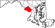
U.S. Routes Interstate Highways Roads by name Cabin John Parkway · Clara Barton Parkway · Cherry Hill Road · Connecticut Avenue · Georgia Avenue · Montrose Road · New Hampshire Avenue · Randolph Road · Sligo Creek Parkway · Wisconsin Avenue · 16th StreetCategories:- State highways in Maryland
- Roads in Montgomery County, Maryland


Wikimedia Foundation. 2010.