- Creslow
-
Coordinates: 51°53′24″N 0°49′25″W / 51.8899°N 0.8236°W
Creslow 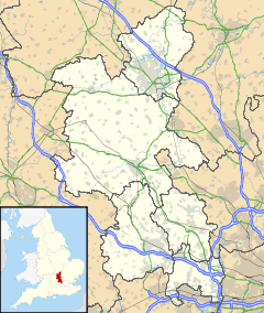
 Creslow
Creslow shown within BuckinghamshirePopulation 19 [1] OS grid reference SP815215 Parish Creslow District Aylesbury Vale Shire county Buckinghamshire Region South East Country England Sovereign state United Kingdom Post town AYLESBURY Postcode district HP22 Dialling code 01296 Police Thames Valley Fire Buckinghamshire Ambulance South Central EU Parliament South East England UK Parliament Aylesbury List of places: UK • England • Buckinghamshire Creslow (occasionally also known as Christlow) is a village and civil parish within Aylesbury Vale district in Buckinghamshire, England. It is close to Whitchurch, about six and a half miles from Aylesbury.
The village name is Anglo Saxon in origin, Cærsehlaw, meaning 'cress hill'. It was recorded in the Domesday Book of 1086 as Cresselai.
The parish church of the village was demolished during the English Civil War, by the regicide Cornelius Holland, and was never replaced. [2]
In the Victorian era there was just one house left in the village, the manor house. This was formerly owned by the Knights Templar and, following their suppression, the Knights Hospitaller. Following the dissolution of the Monasteries it was held by the Crown, and the whole of the manor was used as pasture for the cattle of the Royal Household. It was then the property of Lord Clifford but has also now disappeared.
More recently Creslow was the site of a Foreign and Commonwealth Office/MI6 signals intelligence station, which was closed down in 1998. [3]
References
- ^ MK Observatory Combined Parish data (876) and for Whitchurch (857) and Creslow
- ^ Quick, Kevin (2001-01-01). "Creslow – History & Descriptions". GENUKI. http://met.open.ac.uk/genuki/big/eng/BKM/Creslow/index.html#Descriptions. Retrieved 2006-09-15.
- ^ Turnbull, Alan (2006-08-24). ""Secret Bases" Part 1". Pagliacci Productions Limited. http://www.secret-bases.co.uk/secret.htm#MI6. Retrieved 2006-08-30.
External links
Categories:- Villages in Buckinghamshire
- Civil parishes in Buckinghamshire

Wikimedia Foundation. 2010.