- Civic Center (MARTA station)
-
Civic Center
MARTA rapid transit station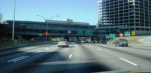
Station statistics Address 435 West Peachtree St NW
Atlanta, GA 30308Coordinates 33°45′59″N 84°23′14″W / 33.766305°N 84.387209°WCoordinates: 33°45′59″N 84°23′14″W / 33.766305°N 84.387209°W Lines Connections CCT, GCT, GRTA Structure Elevated Platforms 2 side platforms Tracks 2 Parking None Bicycle facilities None Other information Opened December 4, 1981 Accessible 
Code N2 Breeze Card Yes Traffic Passengers (2006) .837 million  111%
111%Services Preceding station MARTA Following station toward AirportRed Line toward North SpringsGold Line toward DoravilleCivic Center is an elevated metro station on the Red and Gold lines of the Metropolitan Atlanta Rapid Transit Authority (MARTA) rail system. It is located in the SoNo district of Atlanta. This station has seen an increase of faregate totals and ridership in the past years, mainly because of the increased interest of highrise building in the area.
Contents
Location
Civic Center station is located in SoNo, a sub-district of Downtown, with convenient access to the southern end of Midtown Atlanta. The station is named after the nearby Atlanta Civic Center three blocks east at Piedmont Avenue NE, but serves the Peachtree Summit and SunTrust Plaza skyscrapers to the south. It provides connecting bus service to Georgia State Capitol, The Metro Transitional Center, The Turner Field, Zoo Atlanta, Centennial Olympic Park, The World of Coca-Cola, and The Georgia Aquarium.
Station layout
Civic Center has a unique layout compared to other stations of the MARTA system. Although the rest of the line in Downtown and Midtown is underground, the station is actually elevated. This is because it lies perpendicular to the trench for the Downtown Connector (

 ), but above the roadway, making it the only metro station in the world located above a highway.[1]
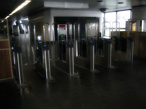
Civic Center Fare Gates
Bus connections
- Route 32 - Bouldercrest / Georgia Aquarium
Connection to other transit systems
References
- ^ MARTA North-South line NYCSubway Retrieved 2009-08-24
External links
Categories:- MARTA stations
- Railway stations opened in 1981
- Railway stations in Atlanta, Georgia
- Atlanta, Georgia stubs
- Rapid transit stubs


Wikimedia Foundation. 2010.