- Hertford Union Canal
-
Hertford Union Canal Junction of Hertford Union Canal and River Lee Navigation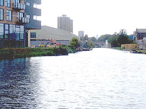
Original owner Sir George Duckett Principal engineer Francis Giles Date of act 1824 Date completed 1830 Maximum boat length 72 ft 0 in (21.95 m) Maximum boat beam 14 ft 0 in (4.27 m) Start point Regents Canal End point River Lee Navigation Locks 3 Status Navigable Navigation authority British Waterways Hertford Union Canal Legend


River Lee Navigation 

3 Old Ford Bottom Lock 
Wansbeck Road 
A12 East Cross Route Cadogan Terrace 2 Old Ford Middle Lock 1 Old Ford Top Lock B118 Old Ford Road A1205 Grove Road 
Regent's Canal The Hertford Union Canal or Duckett's Canal is a short stretch (c. 1.5 km) of canal in the London Borough of Tower Hamlets in east London. It connects the Regent's Canal to the Lee Navigation. It was opened in 1830 but quickly proved to be a commercial failure. It was acquired by the Regents Canal Company in 1857, and became part of the Grand Union Canal in 1927.
Contents
History
Like its 1766 predecessor, the Limehouse Cut, the Hertford Union Canal was intended to provide a short-cut between the River Thames and the River Lee Navigation. It allowed traffic on the Lea heading for the Thames to bypass the tidal, tortuous and often silted Bow Back Rivers of the Lea via a short stretch of the Regent's Canal, and provided a short-cut from the Lea to places west along the Regent's Canal.
The canal was promoted by Sir George Duckett who succeeded in gaining an Act of Parliament that gained its Royal Assent on 17 May 1824, entitled An Act for making and maintaining a navigable Canal from the River Lee Navigation, in the parish of St. Mary Stratford Bow, in the county of Middlesex, to join the Regent's Canal at or near a Place called Old Ford Lock, in the parish of St. Matthew Bethnal Green, in the said county of Middlesex.[1]
The Act authorised Duckett to borrow up to £50,000 to fund construction, and to charge tolls for using the canal, initially one shilling (£0.05) per ton of goods carried.[1]
With Francis Giles appointed as engineer, the canal opened in 1830 and was for some years known as Duckett's Canal or Duckett's Cut. It was not a commercial success, and within a year offers to waive the tolls were being made. For several years around the 1850s it was unnavigable, as a dam was built across it to prevent the Regent's Canal losing water to it. After failed attempts to sell it in 1851, it was eventually acquired by the Regent's Canal Company and became a branch of that canal on 28 October 1857. The new owners removed the dam, and deepened and widened the channel.[2] When the Grand Union Canal Company acquired the Regent's Canal in 1929, it became part of that network. Today, it is maintained by British Waterways.
Route
The canal starts at Hertford Union Junction between Mile End Lock and Old Ford Lock on the Regent's Canal. It passes along the north of Bow Wharf, redeveloped in the 1990s with shops and bars, and after Grove Road, passes south of Lakeview Estate, completed in 1958. For much of the rest of its route it is bounded on the north by Victoria Park. The canal joins the Lee Navigation just above Old Ford Lock.
Many of the associated locks, bridges and other features around the canal, date from the canal's opening in 1830 and are designated listed structures within a scheduled ancient monument.[3]
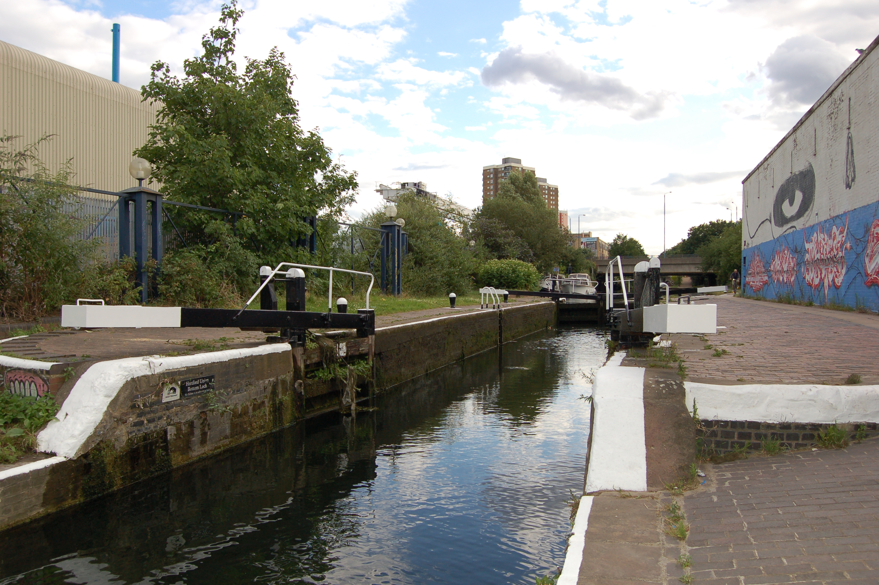
Locks
For other locks of the same name in this area, see Old Ford Lock (disambiguation). Old Ford Upper Lock
 Old Ford Middle Lock
 Old Ford Lower Lock
The three locks on this canal are named Old Ford Locks, all lying within the district of Old Ford. They are grouped together towards the north-eastern end, and descend approximately 19 feet (5.8 m) from the Regent's Canal to the Lee Navigation. These locks are all single manual locks, and the largest craft that can use them have a length of 72 feet and a beam of 14 feet.[4]
Proceeding west to east, the locks are:
Old Ford Upper Lock No. 1
This is lock No.1, and is 0.63 miles (1.0 km) from the Hertford Union Junction with the Regent's Canal. It is to the south of Victoria Park, with the tail of the lock passing beneath a cast iron footbridge accessing the park from Parnell Road.[5] It has a fall of 6 feet 3 inches (1.9 m).[6]
The lock was designated a Grade II listed structure in 1990, and its bottom gates have rare cast iron balance beams.[7] One of the adjacent cottages (No 3 Lock Cottages) is also a Grade II listed building.[8]
51°32′17″N 0°01′47″W / 51.538056°N 0.029783°WOld Ford Middle Lock No. 2
The middle lock has a fall of 8 feet 11 inches (2.7 m)[9] The tail of the lock passes under Cardogan Terrace.
51°32′21″N 0°01′39″W / 51.539082°N 0.027568°WOld Ford Lower Lock No. 3
The lower lock has a fall of 3 feet 9 inches (1.1 m). It is just 0.13 miles (0.2 km) from the junction with the River Lee.[10]
The public house, now the "Top of the Morning", but then the Mitford Castle, by the ramp to the canal, on Wick Road, was where Thomas Briggs – the first victim of a railway murder – was taken to die from his wounds, in July 1864 (see Hackney Wick).[11]
51°32′26″N 0°01′29″W / 51.540610°N 0.024636°WTransport
The nearest London Overground station is Hackney Wick
The canal towpath is open to walkers and cyclists — without permit. At its eastern end, the towpath joins the Lea Valley Walk. At Hackney Wick, the Capital Ring crosses the canal; with section 13 proceeding north-west toward Stoke Newington[12] and section 14, south-east — using The Greenway towards Beckton District Park.[13] The towpath forms part of the "Limehouse Circuit"; commencing at Limehouse Basin and utilising the Limehouse Cut, Lee Navigation, Regent's Canal and Hertford Union in a circular five-mile walk.
The Olympic Park, London is under construction to the east of the Lee Navigation. During the games, there is proposed pedestrian and cycle access to the stadia via newly constructed bridges. In the legacy phase of the 2012 Summer Olympics, there is promised access to the Olympic Park and Bow Back Rivers.
See also
- Canals of Great Britain
- History of the British canal system
References
- ^ a b Priestley, Joseph (1831). Historical Account of the Navigable Rivers, Canals, and Railways, of Great Britain. Longman, Rees, Orme, Brown & Green
- ^ London Canals: Hertford Union: History
- ^ See individual listings for details
- ^ "Boating in London. Facilities, maps and waterways guide". British Waterways. pp. 13. http://www.waterscape.com/media/documents/20849. Retrieved 2008-12-12.
- ^ Details from listed building database (206529) . Images of England. English Heritage. accessed 13 December 2008
- ^ "Old Ford Upper Lock". CanalPlan AC. http://www.canalplan.org.uk/cgi-bin/gazetteer.cgi?id=u5jl. Retrieved 2008-12-12.
- ^ Details from listed building database (206528) . Images of England. English Heritage. accessed 9 December 2008
- ^ Details from listed building database (206527) . Images of England. English Heritage. accessed 9 December 2008
- ^ "Old Ford Middle Lock". CanalPlanAC. http://www.canalplan.org.uk/cgi-bin/gazetteer.cgi?id=$5oga. Retrieved 2008-12-12.
- ^ "Old Ford Lower Lock". CanalplanAC. http://www.canalplan.org.uk/cgi-bin/gazetteer.cgi?id=rprm. Retrieved 2008-12-12.
- ^ Britain's First Railway Murder (Socyberty) accessed 9 December 2008
- ^ Capital Ring Section 13: Stoke Newington to Hackney Wick (TfL) accessed 14 December 2008
- ^ Capital Ring Section 14: Hackney Wick to Beckton District Park (TfL) accessed 14 December 2008
Counties Locks Hertford Lock · Ware Lock · Hardmead Lock · Stanstead Lock · Feildes Weir Lock · Dobbs Weir Lock · Carthagena Lock · Aqueduct Lock · Cheshunt Lock · Waltham Common Lock · Waltham Town Lock · Rammey Marsh Lock · Enfield Lock · Ponder's End Lock · Pickett's Lock · Stonebridge Lock · Tottenham Lock · Pond Lane Flood Gates · Old Ford Lock · Bow LocksWeirs Horns Mill Weir · Hertford Castle Weir · Hartham Weir · Ware Weir · Feildes Weir · Dobbs Weir · Carthagena Weir · Kings Weir · Newmans Weir · Middlesex Filter Beds WeirHertford Union Canal
(branch, below Old Ford)Limehouse Cut
(branch, at Bow Locks)Bow Back Rivers
(branches of the
Old River Lea)Three Mills Lock · City Mill Lock · Carpenter's Road Lock (defunct) · Marshgate Lane Lock (defunct) · Three Mills Wall River Weir
(These rivers form the waterways within the 2012 Olympic Park - they flow into Bow Creek)Categories:- Canals in London
- Transport in Tower Hamlets
- Geography of Tower Hamlets


Wikimedia Foundation. 2010.