- Chamisso Wilderness
-
Chamisso Wilderness IUCN Category Ib (Wilderness Area)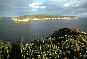
Chamisso IslandLocation Northwest Arctic Borough, Alaska, USA Coordinates 66°13′28″N 161°49′30″W / 66.22444°N 161.825°WCoordinates: 66°13′28″N 161°49′30″W / 66.22444°N 161.825°W Area 455 acres (184 ha) Established 1975 Governing body US Fish and Wildlife Service Chamisso Wilderness is a 455-acre (184 ha) wilderness area in the U.S. state of Alaska. It was designated by the United States Congress in 1975.
A small subunit of the Chukchi Sea Unit of the Alaska Maritime National Wildlife Refuge, Chamisso Island and nearby Puffin Island were combined as a wildlife refuge in 1912, designated Wilderness in 1975, and added to the AMNWR in 1980.[1]
Chamisso Island, named after the naturalist Adelbert von Chamisso, comprises one large sand spit and a low beach zone surrounding a covering of tundra with a few marshy bogs. Although Chamisso Island is much larger, Puffin Island houses many more nesting birds, especially horned puffin, black-legged kittiwake, and thick-billed murre who build their nests on the steep-walled cliffs that fall into Spafarief Bay. Eskimos still cross from the mainland to gather eggs, primarily from kittiwakes and murres. With the exception of birds and the occasional fox that crosses frozen sea in winter, nothing lives on the islands that make up Chamisso Wilderness. Walruses, seals, and whales can often be seen in Spafarief Bay.[1]
References
- ^ a b Chamisso Wilderness - Wilderness.net
External links
- Chamisso Wilderness - Wilderness.net
Protected Areas of Alaska Federal Admiralty Island • Aniakchak • Cape Krusenstern • Misty Fjords • World War II Valor in the Pacific
Alaska Maritime • Alaska Peninsula • Arctic • Becharof • Innoko • Izembek • Kanuti • Kenai • Kodiak • Koyukuk • Nowitna • Saint Lazaria • Selawik • Tetlin • Togiak • Yukon Delta • Yukon Flats
Aleutian Islands • Andreafsky • Becharof • Bering Sea • Bogoslof • Chamisso • Chuck River • Coronation Island • Denali • Endicott River • Forrester Island • Gates of the Artic • Glacier Bay • Hazy Islands • Innoko • Izembek • Karta River • Katmai • Kenai • Kobuk Valley • Kootznoowoo • Koyukuk • Kuiu • Lake Clark • Maurille Islands • Misty Fjords • Mollie Beattie • Noatak • Nunivak • Petersburg Creek-Duncan Salt Chuck • Pleasant/Lemusurier/Inian Islands • Russell Fjord • Saint Lazaria • Selawik • Semidi • Simeonof • South Baranof • South Etolin • South Prince of Wales • Stikine-LeConte • Tebenkof Bay • Togiak • Tracy Arm-Fords Terror • Tuxedni • Unimak • Warren Island • West Chichagof-Yakobi • Wrangell-Saint Elias
Steese National Conservation AreaState Afognak Island State Park • Alaska Chilkat Bald Eagle Preserve • Baranof Castle Hill State Historic Site • Birch Lake State Recreation Site • Chena River State Recreation Area • Chena River State Recreation Site • Chugach State Park • Deep Creek State Recreation Area • Denali State Park • Kachemak Bay State Park • Wood-Tikchik State Park
Haines • Tanana Valley
Categories:- IUCN Category Ib
- Wilderness Areas of Alaska
- Chukchi Sea
- Protected areas of Northwest Arctic Borough, Alaska
- Northern Alaska geography stubs
- Alaska geography stubs
- Western United States protected area stubs

Wikimedia Foundation. 2010.