- Moyle District Council
-
Coordinates: 55°10′16″N 6°13′44″W / 55.171°N 6.229°W
Moyle District Geography 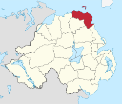
Area
- TotalRanked 14th of 26
480 km²Admin HQ Ballycastle ISO 3166-2 GB-MYL ONS code 95E Demographics Population
- Total (2010)
- DensityRanked 26th
17,000
35 / km²Community Catholic: 60.3%
Protestant: 38.3%Politics Control No overall control
Independents: 4
Sinn Féin: 3
UUP: 3
DUP: 2
SDLP: 2
TUV: 1MLAs North Antrim
DUP: 3
Sinn Féin: 1
TUV: 1
UUP: 1MPs Ian Paisley, Jr. (DUP) Meeting place Website http://www.moyle-council.org Moyle District Council is a Local Council in County Antrim in the north-east corner of Northern Ireland. It covers a largely rural area of approximately 190 square miles (including 42 miles of coastline) and has a population of 15,000. Moyle has the smallest population of any principal local authority in the United Kingdom.
As a consequence, in 1991 the local government boundary commission originally recommended that the council should be merged with the neighbouring Ballymoney council to create a new council called "Dalriada".[1] This was strongly opposed by both councils and also by Ballymena which would have gained the Glens of Antrim and a small part of Ballymoney council in the process. After a public enquiry the plans were shelved and Moyle was preserved.
Council headquarters are in Ballycastle. Other towns in the area include Bushmills (home to the world's oldest licensed distillery which has produced the famous Irish whiskey "Bushmills" since 1608), Ballintoy, Armoy, Cushendall, Cushendun and Waterfoot. The area is very popular with tourists and includes the three best known features of Northern Ireland: the Giant's Causeway (a World Heritage Site), the Glens of Antrim and Rathlin Island (lying 7 miles off Ballycastle).
The Council is composed of 15 Councillors who are elected from three electoral areas (Ballycastle, Giant's Causeway and The Glens) every four years by a system of Proportional Representation. The council's makeup is currently 4 Independent Members, 3 for Sinn Féin, 3 for the Ulster Unionist Party, 2 Social Democratic and Labour Party members, and 2 for the Democratic Unionist Party and one for the Traditional Unionist Voice. The Chairperson and Vice-Chairperson are elected on a yearly basis at the Council's Annual General Meeting in June.
Most of the council forms the North Antrim constituency (together with the neighbouring Local Council areas of Ballymena and Ballymoney), for elections to the Westminster Parliament and Northern Ireland Assembly. The exception is the Glens of Antrim area, most of which is part of the East Antrim constituency.
Contents
2005 Election results
Party seats change +/- • Sinn Féin 4 +3 • Social Democratic and Labour Party 3 -1 • Ulster Unionist Party 3 = • Democratic Unionist Party 2 -1 • Independent 3 -1 Review of Public Administration
Under the Review of Public Administration (RPA) the Council was due to merge with Coleraine Borough Council, Limavady Borough Council and Ballymoney Borough Council in 2011 to form Causeway Coast and Glens District Council, a single council for the enlarged area totalling 1,796 km2 (693 sq mi) and a population of 131,564.[2] The next election was due to take place in May 2009, but on April 25, 2008, Shaun Woodward, Secretary of State for Northern Ireland announced that the scheduled 2009 district council elections were to be postponed until 2011.[3] The merger with Coleraine, Limavady and Ballymoney councils was confirmed in September 2011 and will take effect in 2015.
See also
- Local Councils in Northern Ireland
- Knocknacarry
References
- ^ Irish News, 4th September 1991, p11
- ^ "Minister Foster announces decisions on Local Government Reform". DoE. http://www.doeni.gov.uk/index/local_government/minister_foster_announces_decisions_on_local_government_reform.htm. Retrieved 2008-05-31.
- ^ Northern Ireland elections are postponed, BBC News, April 25, 2008, accessed April 27, 2008
External links
Local authorities of Northern Ireland Antrim · Ards · Armagh · Ballymena · Ballymoney · Banbridge · Belfast · Carrickfergus · Castlereagh · Coleraine · Cookstown · Craigavon · Derry · Down · Dungannon and South Tyrone · Fermanagh · Larne · Limavady · Lisburn · Magherafelt · Moyle · Newry and Mourne · Newtownabbey · North Down · Omagh · Strabane
Categories:- Politics of County Antrim
- Local authorities of Northern Ireland

Wikimedia Foundation. 2010.