- Mersea Island
-
Coordinates: 51°47′45″N 0°56′24″E / 51.79570°N 0.94°E
Mersea Island 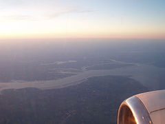
Mersea Island (centre right) viewed from the south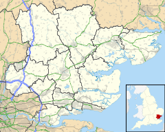
 Mersea Island
Mersea Island shown within EssexPopulation 7,000 OS grid reference TM060150 Parish East Mersea
West MerseaDistrict Colchester Shire county Essex Region East Country England Sovereign state United Kingdom Post town Colchester Postcode district CO5 8 Dialling code 01206 Police Essex Fire Essex Ambulance East of England EU Parliament East of England UK Parliament North Essex List of places: UK • England • Essex Mersea Island (formerly Mersey Island) is the most easterly inhabited island in the United Kingdom, located marginally off the coast of Essex, England, 9 miles (14 km) to the southeast of Colchester. It is situated in the estuary area of the Blackwater and Colne rivers and has an area of around 7 square miles (18 km2).[1] The name 'Mersea' is derived from the Old English meresig meaning 'island of the pool',
Contents
Geography
The island hosts a population of 6,925 and is the most easterly inhabited island in the UK.[2] It is joined to the mainland by a causeway, known as The Strood. This carries the Mersea–Colchester road (B1025) which is often covered at high tides and especially including spring tides. It is close to neighbouring Ray Island. The water separating the island is the Pyefleet Channel to the east and the Strood Channel to the west.[3] There are two main settlements on the island, the small town of West Mersea and the village of East Mersea, plus a small hamlet at Barrow Hill to the north of West Mersea.
Economy
The main industries on Mersea are farming, fishing (including oyster gathering), and servicing the leisure boating industry.
The island has its own newspapers, the Newsround and the Mersea Island Courier. It also has full broadband coverage and the majority of properties, excluding those too close to the beach, can receive Freeview signals.
History
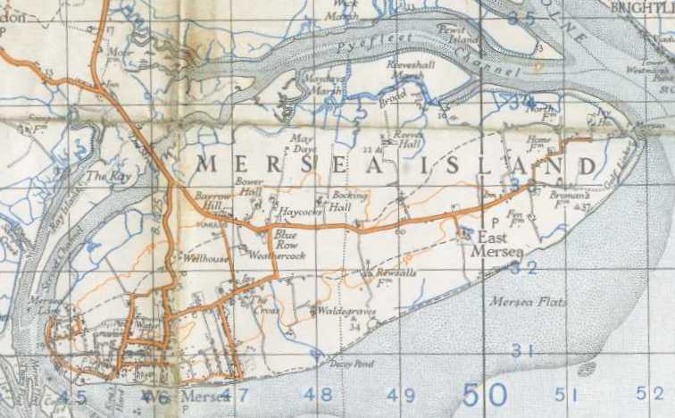
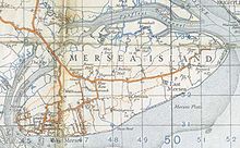 A map of the island in 1940
There is evidence of pre-Roman settlement on Mersea in the form of "red hills" which are evidence of Celtic salt workings. A large Romano-British round barrow near the Strood contained the remains of a cremated adult in a glass urn, within a lead casket,[4] now in the Castle Museum, Colchester. A large mosaic floor was found near West Mersea church.
The Anglo-Saxons built the church at West Mersea (St Peter & St Paul) which may have been founded as early as the 7th century. It was damaged by Norse raiders in 894 and rebuilt afterwards. A moat at East Mersea church (St Edmund, King & Martyr) is thought to be the remains of a Danish encampment. The Strood causeway was also built by the Saxons; oak piles discovered in 1978 have been dated by dendrochronology to between 684 and 702.[5] By 950, there was a Benedictine Priory at West Mersea and land at West Mersea was granted to the Abbey of St Ouen in France by Edward the Confessor in 1046.[6]
The priory was finally dissolved in 1542. In the English Civil War, the Parliamentary Army built a blockhouse at East Mersea in 1648, with the aim of blockading the River Colne and the besieged town of Colchester. During the 16th and 17th centuries, Dutch and French settlers arrived on the island. Some locals supplemented their income from the oyster trade by smuggling. A police officer for the island was appointed in 1844, and in 1871 a school was opened. The Reverend Sabine Baring Gould (author of "Onward Christian Soldiers" and of "Mehalah", a novel set in Mersea) was Rector of East Mersea from 1870-1881.[7] Mains water and sewerage were available by 1925. In World War II, 2000 troops were stationed on the island to guard against invasion; the island was the Headquarters of the Royal Army Corps Motor Boat Company.[8] Two batteries of 4.7 inch guns were installed; one at East Mersea has been demolished and one at West Mersea, now a cafe.[9] Post war, the island suffered from severe winter weather in 1947 which destroyed much of the oyster fishery, and from the flooding of 1953. Since then the population has increased considerably.[10][11]
Education
Mersea Island School is a Foundation Primary School for 420 pupils.[12] The earliest part of the school dates back to 1871, with additions in 1980 and 1996, and a new hall, kitchen and office projected.[13] Secondary education is provided by Thomas Lord Audley School and Language College in Colchester.[14]
Events
 Crossing the Strood in the "Round-the-Island" race
The Mersea Regatta is a week-long late summer festival of boat racing. The week of the festival changes each year depending on the tide tables - it is the last Saturday in August to have a high tide at around midday.
During the week, starting on Monday, there are races for many boat classes - from Optimists up to large yachts. The most celebrated race is the annual 'Round-the-Island' race in which about 200 dinghies attempt to sail all the way around the island, helped over the Strood by volunteers. These races usually take place in the Blackwater Estuary (also known as the Mersea Quarters).
The Grande Finale on the final Saturday includes harbour fun: short spectator inshore races, soot and flour fights on the water, the Greasy Pole, fireworks and the week's Awards Ceremony. During the day there is a plethora of street entertainment, hot dog vendors, ice-cream vans etc.
In the Greasy Pole event, contenders have to traverse a telegraph pole/mast covered in thick grease and extended out over the water from the deck of the Regatta hosting Thames sailing barge (similar to 'walking the plank'), retrieve the flag at the end and return to the boat with the flag in hand. Annually a handful of the 50 or so contenders get to the end of the pole and grab the flag (an accomplishment in itself!) but rarely more than one, if any, will bring it back to the Barge.[15]
Literature
The island is used as a setting for several works of Margery Allingham, such as Mystery Mile and The Mind Readers. Mehalah is a novel set in Mersea by Sabine Baring-Gould.
See also
- Cobmarsh Island
- Osea Island
- Ray Island
References
- ^ "Largest Islands of the United Kingdom". users.erols.com. http://users.erols.com/jcalder/UK.htm. Retrieved 2009-08-30.
- ^ Westmersea.org
- ^ OS Explorer Map, Sheet 184, Colchester, Harwich & Clacton-on-Sea
- ^ Merseamuseum.org
- ^ http://cat.essex.ac.uk/reports/EAS-report-0023.pdf
- ^ http://cat.essex.ac.uk/reports/EAS-report-0019.pdf
- ^ Merseacofe.org
- ^ Westmersea.org
- ^ Essexcc.gov.uk
- ^ Merseamuseum.org.uk
- ^ A Short History of Mersea, Elsie M Karbacz 1999, ISBN 0-9537322-0-7
- ^ http://www.merseaislandschool.org.uk/info/ofsted_report_2009.pdf
- ^ http://www.merseaislandschool.org.uk/info/brochure_01.htm#HISTORY_AND_ENVIRONMENT
- ^ http://www.tla.essex.sch.uk/
- ^ Mersearegatta.org.uk
External links
- The Mersea Community and Business Portal, west-mersea.co.uk
- The Mersea Island Community Website, mersea-island.com
- Webcam of Mersea Island and The Strood, streamdays.com
Categories:- Islands of Essex
- Colchester
- Populated coastal places in Essex


Wikimedia Foundation. 2010.