- River, Kent
-
For other uses, see River (disambiguation).
Coordinates: 51°08′41″N 1°16′47″E / 51.1447°N 1.2797°E
River 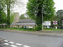
Church of St Peter & St Paul, River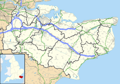
 River
River
River shown within KentPopulation 3,775 (parish); 4,466 (ward) (2001 census)[1][2] OS grid reference TR295435 District Dover Shire county Kent Region South East Country England Sovereign state United Kingdom Post town DOVER Postcode district CT17 Dialling code 01304 Police Kent Fire Kent Ambulance South East Coast EU Parliament South East England UK Parliament Dover List of places: UK • England • Kent River is a village and civil parish[1] in Kent, England, United Kingdom, situated between the historic town of Dover and the neighbouring village of Temple Ewell. "Village" is a somewhat loose term for River; it is a community of several thousand and is probably more usefully regarded as a suburb of Dover. After a period of rapid housing development in the 1960s and 1970s, the size and population of River has largely stabilised in recent decades, and little new development is now seen. This is partly because River lies in a steep chalk valley which affords little scope for further expansion. However, it is also true that the Dover area is historically not in the vanguard of high economic growth, being tied almost exclusively to the cross-channel port and various support industries, which have witnessed a gradual decline since the opening of the Channel Tunnel. In transport terms River is well connected, being close to the A2 and A20 trunk routes, having a railway station at Kearsney with direct services to London, and of course being only 3 miles (5 km) from the Port of Dover itself.
River is also one of the wards in the Dover local government district. The ward also includes the parish of Alkham, situated west of River.[2]
Geographically speaking, River is situated in a steep wooded valley formed by the River Dour. At its north-west (upstream) end the valley splits into the Dour Valley, in which Temple Ewell lies, and the Alkham Valley, which for much of the time is dry but which contains the Drellingore, a highly seasonal stream characteristic of chalk downland (another example being the nearby Nailbourne). The confluence of the Dour and Drellingore rivers is situated in Kearsney Abbey near its Lower Road entrance.
At the valley floor, River is on average about 100 feet (30 m) above sea level (there is a mark on the playground wall of River Primary School, Lewisham Road, to indicate the 100-foot level). Along the axis of the Dour, the land slopes gradually down towards the sea about 3 miles (5 km) distant. In valley cross-section, the land slopes steeply updwards and is heavily wooded. The common land areas above Kearsney Abbey afford excellent views down towards Dover and its historic castle, and much of the area consists of rare and delicate chalk grassland.
River comes under the jurisdiction of Dover District Council and is in the Dover and Deal parliamentary constituency. River has had its own Parish Council since 1987.
Being a relatively stable community, River has a strong identity and sense of place, even though there is no longer any definable focal point such as a green or pond. The village has a primary school of about 400 pupils, taking almost all of its intake from the village itself. Its population supports a wide variety of local interest groups such as drama (the Dour Dramatic Players), gardening (the River Gardeners), and many others. The Village Hall in Common Lane is the focus for many of these society activities. There are two pubs, the Royal Oak and the Dublin Man 'o' War. Teams from these pubs meet every Boxing Day for a traditional tug of war across the lake in Kearsney Abbey.
There are two significant green areas, the River Recreation Ground (the "Rec") and Kearsney Abbey. Despite its name, Kearsney Abbey was never a monastic estate. "Abbey" was simply the name given to a manor house built by the Fector family in the early 19th century on the Kearsney Manor estate. The house fell into disrepair after World War II and was demolished in about 1960. All that remains of the building today is the billiards room, which now serves as a café.
There are other green spaces nearby, notably Crabble Athletic Ground (home of Dover Athletic F.C.) situated at the Dover end of Lewisham Road, and Russell Gardens/Bushy Ruff, situated on the Alkham Valley Road beyond Kearsney Abbey.
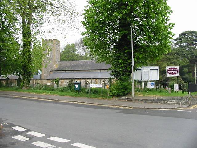
There are two thriving churches, the Parish Church of St Peter and St Paul in Minnis Lane, and the Methodist Church on Lewisham Road. The parish church celebrated its 800th anniversary in 1995; the Methodist Church its 100th round about the same time.
The nucleus of River (the "older" areas of the village, around Lower Road, Common Lane, River Street and Minnis Lane) dates from the 1800s or earlier. Most of the development post-dates this; Lewisham Road, Valley Road, Byllan Road and surroundings probably from the 1930s, and "the estate" around The Ridgeway and Crabble Lane, plus the floodplain developments of Riverdale and Kingston Close, from the 1960s and 1970s.
In its heyday, River had a number of shops, but most of these have gradually closed over the years. While the village presently has three grocery-type shops, the Co-op on Lower Road, a greengrocer on Common Lane, and Coxhill Stores on Lewisham Road, right up to the 1970s there were at least four others: Waterfall Stores on Minnis Lane, Simmons' on River Street, Stoker's hardware store on Lower Road, and Harris's on Lewisham Road. There was also a butcher next to the Co-op. The increasing ease of transport links into Dover, and nearby Folkestone and Canterbury, and the growth of out-of-town developments around Whitfield, have, as with so many other places, squeezed the market for small local shops to the point of unsustainability. River retains its post office.
River has a park called Kearsney Abbey, and another two adjacent parks called Russell Gardens and Bushy Ruff.
Mills
River owes its early existence to milling. The River Dour, which runs through the village and along which Lower Road is built, once supported several water-powered flour and paper mills. One of them, formerly known as Mannering's Mill but now known as Crabble Corn Mill (built in 1812), survives in working form. It now promotes itself as a visitor attraction, offering a pleasant lakeside setting and restaurant as well as educational and historical resources. The site of the other major mill within "old" River is now long since disused and forms an attractive and atmospheric landmark at the downstream end of Kearsney Abbey, known locally as "The Ruins". It forms excellent habitat for water-loving birds such as grey wagtails and kingfishers. Other mills existed further downstream but all have now been either demolished or converted for other industry or housing.
References
- ^ a b "2001 Census: Key Statistics: Parish Headcounts: Area: River CP (Parish)". Neighbourhood Statistics. Office for National Statistics. http://neighbourhood.statistics.gov.uk/dissemination/LeadTableView.do?a=7&b=795453&c=River&d=16&e=15&g=458040&i=1001x1003x1004&m=0&r=1&s=1225918180390&enc=1&dsFamilyId=779. Retrieved 2008-11-05.
- ^ a b "2001 Census: Census Area Statistics: Key Figures: Area: River (Ward)". Neighbourhood Statistics. Office for National Statistics. http://neighbourhood.statistics.gov.uk/dissemination/LeadKeyFigures.do?a=7&b=6078910&c=River&d=14&e=16&g=458038&i=1001x1003x1004&m=0&r=1&s=1225918545921&enc=1. Retrieved 2008-11-05.
External links
 Media related to River, Kent at Wikimedia Commons
Settlements in the Dover district of Kent 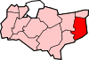
Towns Villages and hamlets Alkham · Ash · Ashley · Aycliff · Aylesham · Barfrestone · Barnsole · Betteshanger · Buckland · Buttsole · Capel-le-Ferne · Chillenden · Church Whitfield · Coldred · Coombe · Denton · Drellingore · East Langdon · Eastry · East Studdal · Elmstone · Elvington · Ewell Minnis · Eythorne · Farthingloe · Finglesham · Frogham · Goodnestone · Great Mongeham · Little Mongeham · Guston · Hacklinge · Ham · Hoaden · Hougham · Kearsney · Kingsdown · Knowlton · Langdon · Lydden · Marley · Marshborough · Martin · Martin Mill · Maxton · Nonington · Northbourne · Preston-next-Wingham · Richborough · Ringwould · Ripple · River · Shepherdswell · Sholden · Sibertswold · Snowdown · St Margaret-at-Cliffe · Staple · Stourmouth · Sutton · Swingate · Temple Ewell · Tilmanstone · Waldershare · Ware · West Langdon · West Studdal · Westcliffe · Westmarsh · Whitfield · Wingham · Woodnesborough · Wootton · WorthCivil parishes Categories:- Villages in Kent
- Civil parishes in Kent


Wikimedia Foundation. 2010.