- Dover (district)
-
Dover District — Non-metropolitan district — Dover shown within Kent
Sovereign state United Kingdom Constituent country England Region South East England Non-metropolitan county Kent Status Non-metropolitan district Admin HQ Dover Incorporated 1 April 1974 Government – Type Non-metropolitan district council – Body Dover District Council – Leadership Leader & Cabinet (Conservative) – MPs Charlie Elphicke
Laura SandysArea – Total 121.6 sq mi (314.84 km2) Area rank 136th (of 326) Population (2010 est.) – Total 106,900 – Rank 211th (of 326) – Density 879.4/sq mi (339.5/km2) – Ethnicity 98.5% White Time zone GMT (UTC0) – Summer (DST) BST (UTC+1) ONS code 29UE OS grid reference TR315415 Website www.dover.gov.uk Dover is a local government district in Kent, England. Dover is its administrative centre. It was formed on 1 April 1974 by the merger of the boroughs of Deal, Dover, and Sandwich along with Dover Rural District and most of Eastry Rural District. There are three towns within the district: Dover, Deal and Sandwich; and the parishes below:
- Alkham
- Ash
- Aylesham
- Capel-le-Ferne
- Denton with Wootton
- Eastry
- Eythorne
- Goodnestone
- Great Mongeham
- Guston
- Hougham without
- Langdon
- Lydden
- Nonington
- Northbourne
- Preston
- Ringwould with Kingsdown
- Ripple
- River
- Shepherdswell with Coldred
- Sholden
- St Margaret-at-Cliffe
- Staple
- Stourmouth
- Sutton by Dover
- Temple Ewell
- Tilmanstone
- Walmer
- Whitfield
- Wingham
- Woodnesborough
- Worth
The northern boundary of the district is the River Stour; on its eastern side is the district of Canterbury; to the south the parish of Capel-le-Ferne; and to the east the Straits of Dover. The southern part of the latter is the point where the North Downs meets the sea, at the so-called ‘White cliffs of Dover’. Further north along the coast, from Deal onwards, the land is at sea level, where the River Stour enters the sea by a circuitous route. It is here, on the sand-dunes, that the Royal St George's Golf Club, founded in 1887, and of international repute, is situated.
In the district are industrial remains of the erstwhile Kent coalfield, situated around Tilmanstone and Betteshanger. Technically speaking, half of the underwater section of the Channel Tunnel is under British Sovereignty and thus part of the district.
Communications
Crossing Dover district are the Roman roads of Watling Street and that leading from Richborough. Today the main road, the A2, closely follows Watling Street to Dover.
External links
- Parish listing
- Kent coalfield history
- Dover Soul Local Website for Dover & White Cliffs Country: history, geography, Kent's radio history, pictures and community information
- Dover pictorial website
- Dover Community Radio (DCR)
Settlements in the Dover district of Kent 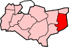
Towns Villages and hamlets Alkham · Ash · Ashley · Aycliff · Aylesham · Barfrestone · Barnsole · Betteshanger · Buckland · Buttsole · Capel-le-Ferne · Chillenden · Church Whitfield · Coldred · Coombe · Denton · Drellingore · East Langdon · Eastry · East Studdal · Elmstone · Elvington · Ewell Minnis · Eythorne · Farthingloe · Finglesham · Frogham · Goodnestone · Great Mongeham · Little Mongeham · Guston · Hacklinge · Ham · Hoaden · Hougham · Kearsney · Kingsdown · Knowlton · Langdon · Lydden · Marley · Marshborough · Martin · Martin Mill · Maxton · Nonington · Northbourne · Preston-next-Wingham · Richborough · Ringwould · Ripple · River · Shepherdswell · Sholden · Sibertswold · Snowdown · St Margaret-at-Cliffe · Staple · Stourmouth · Sutton · Swingate · Temple Ewell · Tilmanstone · Waldershare · Ware · West Langdon · West Studdal · Westcliffe · Westmarsh · Whitfield · Wingham · Woodnesborough · Wootton · WorthCivil parishes  Districts of South East England
Berkshire 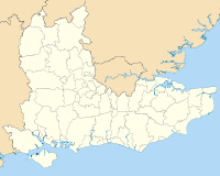
Buckinghamshire Aylesbury Vale • Chiltern • Milton Keynes • South Bucks • Wycombe
East Sussex Brighton and Hove • Eastbourne • Hastings • Lewes • Rother • Wealden
Hampshire Basingstoke and Deane • East Hampshire • Eastleigh • Fareham • Gosport • Hart • Havant • New Forest • Portsmouth • Rushmoor • Southampton • Test Valley • Winchester
Isle of Wight Kent Ashford • Canterbury • Dartford • Dover • Gravesham • Maidstone • Medway • Sevenoaks • Shepway • Swale • Thanet • Tonbridge and Malling • Tunbridge Wells
Oxfordshire Surrey Elmbridge • Epsom and Ewell • Guildford • Mole Valley • Reigate and Banstead • Runnymede • Spelthorne • Surrey Heath • Tandridge • Waverley • Woking
West Sussex Adur • Arun • Chichester • Crawley • Horsham • Mid Sussex • Worthing
Categories:- Local government in Kent
- Dover (district)
- Non-metropolitan districts of Kent
- Local government districts of South East England


Wikimedia Foundation. 2010.